Stampa:Urartu 715 713-en.svg

Size of this PNG preview of this SVG file: 800 × 513 pixels. Riżoluzzjonijiet oħra: 320 × 205 pixels | 640 × 410 pixels | 1,024 × 657 pixels | 1,280 × 821 pixels | 2,560 × 1,641 pixels | 2,714 × 1,740 pixels
Fajl oriġinali (Fajl fil-format SVG, dimensjoni nominali 2,714 × 1,740 pixel, dimensjoni tal-fajl: 881 KB)
| Dan huwa fajl mill-Wikimedia Commons. Il-deskrizzjoni fuq il-paġna ta' diskussjoni oriġinali tidher hawn taħt.
|
Taqsira
| Deskrizzjoni |
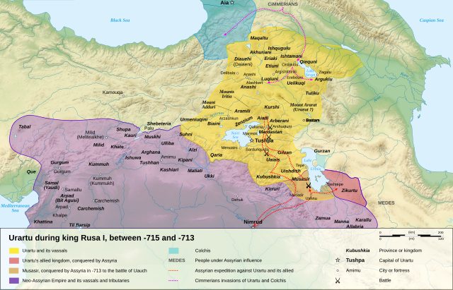
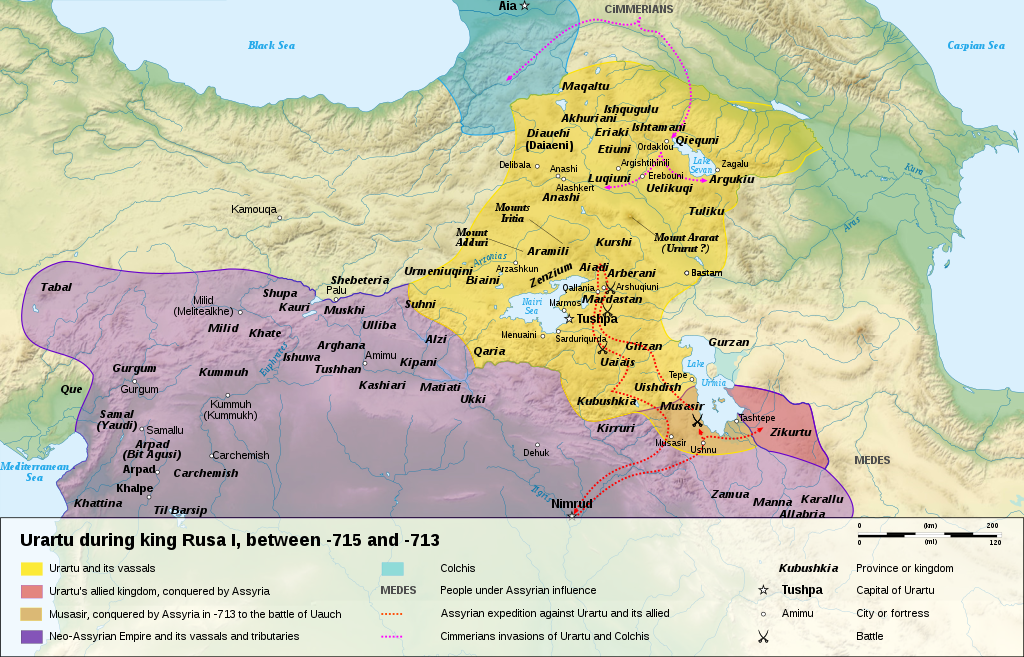
English: Map of the kingdom of Urartu, between -715 and -713.
Français : Carte en anglais du royaume d'Urartu, entre -715 et -713. |
||
| Data | |||
| Sors |
Own work.
Sources :
Software used :
Other data :
|
||
| Awtur | Sémhur | ||
| Verżjonijiet oħra |
See Urartu.
| ||
| Attribuzzjoni (required by the license) | © Sémhur / Wikimedia Commons / | ||
| SVG | W3C-validity not checked.
|
||
| Atelier graphique |


| Camera location | | View this and other nearby images on: OpenStreetMap |
|---|
Liċenzja
Jiena, id-detentur tal-copyright ta' dan ix-xogħol, niddikjara li se nippubblikah taħt il-liċenzji segwenti:
| Copyleft: This work of art is free; you can redistribute it and/or modify it according to terms of the Free Art License. You will find a specimen of this license on the Copyleft Attitude site as well as on other sites. |
This file is licensed under the Creative Commons Attribution-Share Alike 4.0 International, 3.0 Unported, 2.5 Generic, 2.0 Generic and 1.0 Generic license.
- Inti ħieles:
- li taqsam – li tikkopja, tiddistribwixxi u tittrażmetti din l-opra
- li timmodifika – li tadatta l-biċċa xogħol
- Taħt il-kundizzjonijiet segwenti:
- attribuzzjoni – Għandek tattribwixxi x-xogħol bil-mod speċifikat mill-awtur jew minn min ta l-l-iċenzja (imma mhux b'xi mod li jissuġġerixxi ji jappoġjaw lilek jew l-użu tax-xogħol).
- Ixxerja bl-istess mod – Jekk tbiddel, tittrasforma jew tibni fuq dan il-materjal, inti għandek bżonn taqsam il-kontribuzzjonijiet tiegħek taħt l-istess liċenzja jew waħda li taqbel ma' dik oriġinali.
Tista' tagħżel il-liċenzja li tippreferi.
| Annotations | This image is annotated: View the annotations at Commons |
Kronoloġija tal-fajl
Agħfas fuq il-grupp data/ħin biex tara l-fajl biex tara kif jidher dak il-ħin.
| Data/Ħin | Minjatura | Qisien | Utent | Kumment | |
|---|---|---|---|---|---|
| kurrenti | 16:15, 10 Jannar 2008 | | 2,714 × 1,740 (881 KB) | Sémhur | == Description == {{Information |Description= {{en| Map of the kingdom of Urartu, between -715 and -713.}} {{fr| Carte en anglais du royaume d'Urartu, entre -715 et -713.}} |Source=Own work. {{clr}} Sources : * Topographic background : [http://www2.jpl.na |
Użu tal-fajl
L-użu globali tal-fajl
Il-wikis segwenti jużaw dan il-fajl:
- Użu fuq als.wikipedia.org
- Użu fuq ast.wikipedia.org
- Użu fuq avk.wikipedia.org
- Użu fuq azb.wikipedia.org
- Użu fuq bg.wikipedia.org
- Użu fuq ckb.wikipedia.org
- Użu fuq cs.wikipedia.org
- Użu fuq de.wikipedia.org
- Użu fuq en.wikipedia.org
- Użu fuq eo.wikipedia.org
- Użu fuq et.wikipedia.org
- Użu fuq fr.wikipedia.org
- Użu fuq fy.wikipedia.org
- Użu fuq gl.wikipedia.org
- Użu fuq hy.wikipedia.org
- Użu fuq id.wikipedia.org
- Użu fuq ja.wikipedia.org
- Użu fuq ka.wikipedia.org
- Użu fuq no.wikipedia.org
- Użu fuq pl.wikipedia.org
- Użu fuq pnb.wikipedia.org
- Użu fuq sl.wikipedia.org
- Użu fuq sr.wikipedia.org
Ara l-użu globali ta' dan il-fajl.