Stampa:Un-poland.png

Fajl oriġinali (3,038 × 2,364 pixel, dimensjoni: 2.25 MB, tip ta' MIME: image/png)
| Dan huwa fajl mill-Wikimedia Commons. Il-deskrizzjoni fuq il-paġna ta' diskussjoni oriġinali tidher hawn taħt.
|
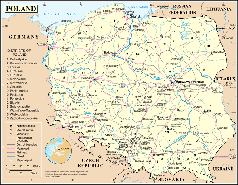
| This image is a map derived from a United Nations map.
Unless stated otherwise, UN maps are to be considered in the public domain. This applies worldwide. UN maps are, in principle, open source material and you can use them in your work or for making your own map. UN requests however that you delete the UN name, logo and reference number upon any modification to the map. Content of your map will be your responsibility. You can state in your publication, if you wish, something like: based on UN map … (map name, map number, revision number and date). See: Geospatial Information Section. And: Geospatial, location data for a better world. |
 |
Kronoloġija tal-fajl
Agħfas fuq il-grupp data/ħin biex tara l-fajl biex tara kif jidher dak il-ħin.
| Data/Ħin | Minjatura | Qisien | Utent | Kumment | |
|---|---|---|---|---|---|
| kurrenti | 02:02, 24 Ottubru 2007 | | 3,038 × 2,364 (2.25 MB) | Jeroen | {{UN map}} Category:Maps of Poland |
Użu tal-fajl
Il-Paġna segwenti twassal għal din l-istampa:
L-użu globali tal-fajl
Il-wikis segwenti jużaw dan il-fajl:
- Użu fuq af.wikipedia.org
- Użu fuq ar.wikipedia.org
- Użu fuq as.wikipedia.org
- Użu fuq azb.wikipedia.org
- Użu fuq az.wiktionary.org
- Użu fuq bh.wikipedia.org
- Użu fuq bjn.wikipedia.org
- Użu fuq el.wikipedia.org
- Użu fuq en.wikipedia.org
- Użu fuq en.wiktionary.org
- Użu fuq ff.wikipedia.org
- Użu fuq gom.wikipedia.org
- Użu fuq incubator.wikimedia.org
- Użu fuq mai.wikipedia.org
- Użu fuq nl.wikipedia.org
- Użu fuq pl.wiktionary.org
Ara l-użu globali ta' dan il-fajl.