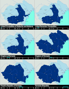
Stampa:RomaniaBorderHistoryAnnimation 1859-2010.gif

Daqs tad-dehra proviżorja: 696 × 599 pixels. Riżoluzzjonijiet oħra: 279 × 240 pixels | 558 × 480 pixels | 1,000 × 861 pixels
Fajl oriġinali (1,000 × 861 pixel, dimensjoni: 162 KB, tip ta' MIME: image/gif, ċiklika, 12 frejms, 36 s)
Kronoloġija tal-fajl
Agħfas fuq il-grupp data/ħin biex tara l-fajl biex tara kif jidher dak il-ħin.
| Data/Ħin | Minjatura | Qisien | Utent | Kumment | |
|---|---|---|---|---|---|
| kurrenti | 22:02, 9 Marzu 2012 |  | 1,000 × 861 (162 KB) | Scooter20 | Better colors! |
| 16:07, 8 Settembru 2010 |  | 1,000 × 861 (168 KB) | Mihai Andrei | Corrected the name of the city of Cluj for the period until 1975. | |
| 00:09, 4 Settembru 2010 |  | 1,000 × 861 (163 KB) | Anonimizat XXX | (I tried to revert to the version from april 2010 but it didn't work, so I've decided to manually upload again) | |
| 00:02, 4 Settembru 2010 |  | 1,000 × 861 (163 KB) | Anonimizat XXX | Reverted to version as of 20:45, 21 April 2010 (animation broken, also, the name of Cluj is actually Cluj-Napoca as the original gif indicate) | |
| 18:02, 9 Awwissu 2010 |  | 1,000 × 861 (73 KB) | Mihai Andrei | Corrected the name of the city of Cluj. | |
| 20:45, 21 April 2010 |  | 1,000 × 861 (163 KB) | File Upload Bot (Magnus Manske) | {{BotMoveToCommons|en.wikipedia|year={{subst:CURRENTYEAR}}|month={{subst:CURRENTMONTHNAME}}|day={{subst:CURRENTDAY}}}} {{Information |Description={{en|Timeline of the borders of Romania between 1859 and 2010.<br/> == Other versions == [[:en:Image:Flag_of |
Użu tal-fajl
Il-Paġna segwenti twassal għal din l-istampa:
L-użu globali tal-fajl
Il-wikis segwenti jużaw dan il-fajl:
- Użu fuq af.wikipedia.org
- Użu fuq ar.wikipedia.org
- Użu fuq ary.wikipedia.org
- Użu fuq ast.wikipedia.org
- Użu fuq azb.wikipedia.org
- Użu fuq bcl.wikipedia.org
- Użu fuq da.wikipedia.org
- Użu fuq de.wikipedia.org
- Użu fuq el.wikipedia.org
- Użu fuq en.wikipedia.org
- Romania
- History of Romania
- Former administrative divisions of Romania
- Kingdom of Romania
- Romanians
- Administrative divisions of Romania
- Portal:Romania
- User:Scooter20
- Union of Transylvania with Romania
- User:Iadrian yu
- User talk:Iadrian yu/Archive April,2010
- Territorial evolution of Romania
- 2010 in Romania
- User:Falcaorib/Romania and Moldova
- Użu fuq et.wikipedia.org
- Użu fuq eu.wikipedia.org
- Użu fuq fa.wikipedia.org
- Użu fuq fi.wikipedia.org
- Użu fuq it.wikipedia.org
- Użu fuq ja.wikipedia.org
- Użu fuq ka.wikipedia.org
- Użu fuq lv.wikipedia.org
- Użu fuq mk.wikipedia.org
- Użu fuq no.wikipedia.org
- Użu fuq pt.wikipedia.org
- Użu fuq ro.wikibooks.org
Ara l-użu globali ta' dan il-fajl.