Stampa:Mountainous Armenia 1921.png
Daqs tad-dehra proviżorja: 656 × 599 pixels. Riżoluzzjonijiet oħra: 263 × 240 pixels | 526 × 480 pixels | 934 × 853 pixels
Fajl oriġinali (934 × 853 pixel, dimensjoni: 47 KB, tip ta' MIME: image/png)
| Dan huwa fajl mill-Wikimedia Commons. Il-deskrizzjoni fuq il-paġna ta' diskussjoni oriġinali tidher hawn taħt.
|
Taqsira
| Deskrizzjoni |
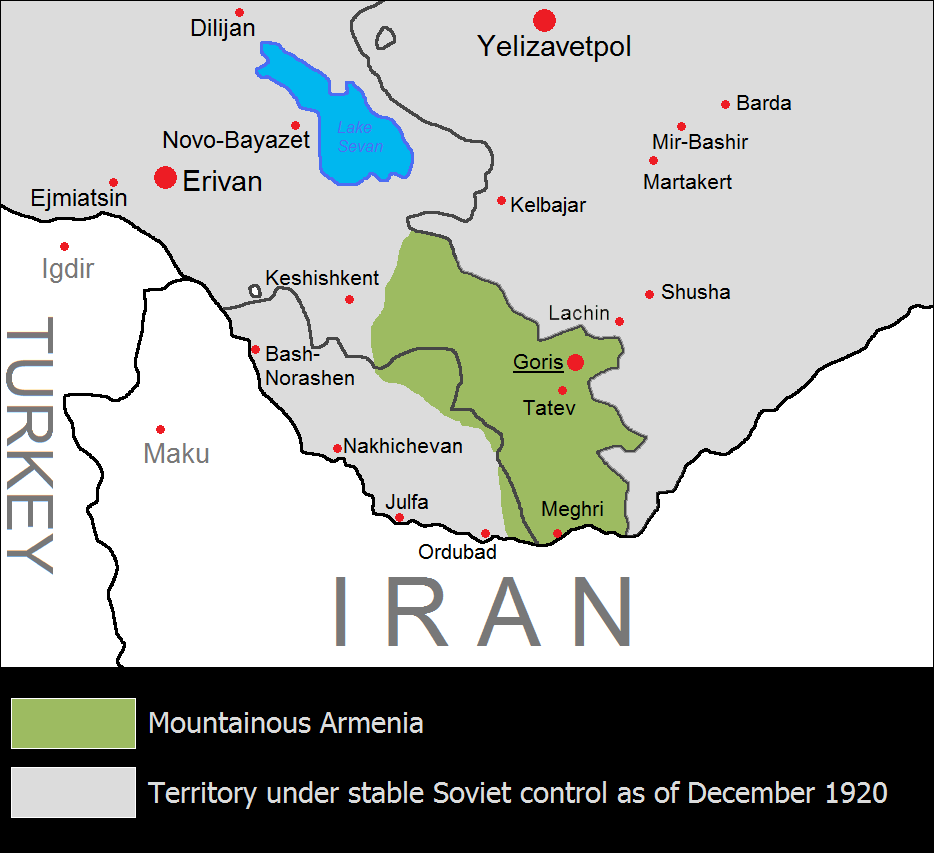
English: The Republic of Mountainous Armenia from December 1920 to June 1921. Mhux magħruf |
| Data | |
| Sors | Opra proprja |
| Awtur | Yerevanci |
Liċenzja
Jiena, id-detentur tal-copyright ta' dan ix-xogħol, niddikjara li se nippubblikah taħt il-liċenzja segwenti:
Dan il-fajl huwa liċenzjat taħt it-termini tal-liċenzja Creative Commons Attribuzzjoni-Aqsam bl-istess mod 3.0 Unported
- Inti ħieles:
- li taqsam – li tikkopja, tiddistribwixxi u tittrażmetti din l-opra
- li timmodifika – li tadatta l-biċċa xogħol
- Taħt il-kundizzjonijiet segwenti:
- attribuzzjoni – Għandek tattribwixxi x-xogħol bil-mod speċifikat mill-awtur jew minn min ta l-l-iċenzja (imma mhux b'xi mod li jissuġġerixxi ji jappoġjaw lilek jew l-użu tax-xogħol).
- Ixxerja bl-istess mod – Jekk tbiddel, tittrasforma jew tibni fuq dan il-materjal, inti għandek bżonn taqsam il-kontribuzzjonijiet tiegħek taħt l-istess liċenzja jew waħda li taqbel ma' dik oriġinali.

|
This historical map image could be re-created using vector graphics as an SVG file. This has several advantages; see Commons:Media for cleanup for more information. If an SVG form of this image is available, please upload it and afterwards replace this template with
{{vector version available|new image name}}.
It is recommended to name the SVG file “Mountainous Armenia 1921.svg”—then the template Vector version available (or Vva) does not need the new image name parameter. |
Kronoloġija tal-fajl
Agħfas fuq il-grupp data/ħin biex tara l-fajl biex tara kif jidher dak il-ħin.
| Data/Ħin | Minjatura | Qisien | Utent | Kumment | |
|---|---|---|---|---|---|
| kurrenti | 11:56, 18 Awwissu 2023 | | 934 × 853 (47 KB) | Golden | Reverted to version as of 21:15, 17 July 2023 (UTC) It did not match the borders of East Zangezur either. Lachin city was under the control of Azeri-soviet forces by the time of this map. This file has no source anyway, it should not be used in Wikipedia articles |
| 18:11, 16 Awwissu 2023 |  | 934 × 853 (53 KB) | Kevo327 | Reverted to version as of 19:44, 17 July 2023 (UTC) I highly doubt the borders matched perfectly to the ones the Soviets drew | |
| 21:15, 17 Lulju 2023 |  | 934 × 853 (47 KB) | Golden | Reverted to version as of 17:33, 17 July 2023 (UTC) The map itself has no source. Mountainous Armenia almost never controlled East Zangezur and was under Soviet control during this time (not Azeri, sorry for the confusion) | |
| 19:44, 17 Lulju 2023 |  | 934 × 853 (53 KB) | Rototekaraka | Reverted to version as of 17:55, 15 July 2023 (UTC) No source was provided to the edit made by the user Golden in regards to "east Zangezur (modern Azerbaijan) was under Azeri control at this time". The Azerbaijan Democratic Republic had ceased to exist in april of 1920, nearly 8 months before the Mountainous Republic of Armenia was established making it impossible for the lands highlighted by the edit to be "under Azeri control at this time". | |
| 17:33, 17 Lulju 2023 |  | 934 × 853 (47 KB) | Golden | Reverted to version as of 08:47, 17 July 2023 (UTC) vandalism | |
| 10:17, 17 Lulju 2023 |  | 934 × 853 (53 KB) | Rototekaraka | Reverted to version as of 17:55, 15 July 2023 (UTC) | |
| 08:47, 17 Lulju 2023 |  | 934 × 853 (47 KB) | Golden | Reverted to version as of 14:39, 1 November 2022 (UTC) rv vandalism | |
| 17:55, 15 Lulju 2023 |  | 934 × 853 (53 KB) | Rototekaraka | Reverted to version as of 03:51, 3 February 2015 (UTC) | |
| 14:39, 1 Novembru 2022 |  | 934 × 853 (47 KB) | Golden | east Zangezur (modern Azerbaijan) was under Azeri control at this time | |
| 03:51, 3 Frar 2015 |  | 934 × 853 (53 KB) | Yerevantsi | tweak |
Użu tal-fajl
Il-Paġna segwenti twassal għal din l-istampa:
L-użu globali tal-fajl
Il-wikis segwenti jużaw dan il-fajl:
- Użu fuq az.wikipedia.org
- Użu fuq be-tarask.wikipedia.org
- Użu fuq de.wikipedia.org
- Użu fuq en.wikipedia.org
- Użu fuq eo.wikipedia.org
- Użu fuq eo.wikinews.org
- Użu fuq es.wikipedia.org
- Użu fuq fi.wikipedia.org
- Użu fuq fr.wikipedia.org
- Użu fuq id.wikipedia.org
- Użu fuq ja.wikipedia.org
- Użu fuq ka.wikipedia.org
- Użu fuq ko.wikipedia.org
- Użu fuq nl.wikipedia.org
- Użu fuq pl.wikipedia.org
- Użu fuq pt.wikipedia.org
- Użu fuq ru.wikipedia.org
- Użu fuq tr.wikipedia.org
- Użu fuq uk.wikipedia.org
- Użu fuq vi.wikipedia.org
- Użu fuq www.wikidata.org
- Użu fuq zh.wikipedia.org