Stampa:Mauretania et Numidia.jpg

Fajl oriġinali (3,509 × 1,383 pixel, dimensjoni: 494 KB, tip ta' MIME: image/jpeg)
| Dan huwa fajl mill-Wikimedia Commons. Il-deskrizzjoni fuq il-paġna ta' diskussjoni oriġinali tidher hawn taħt.
|
Taqsira
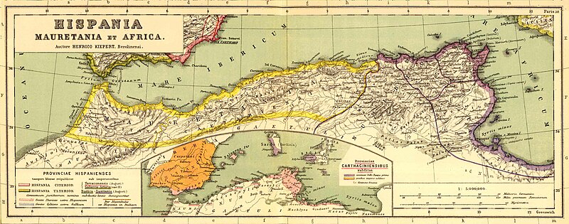
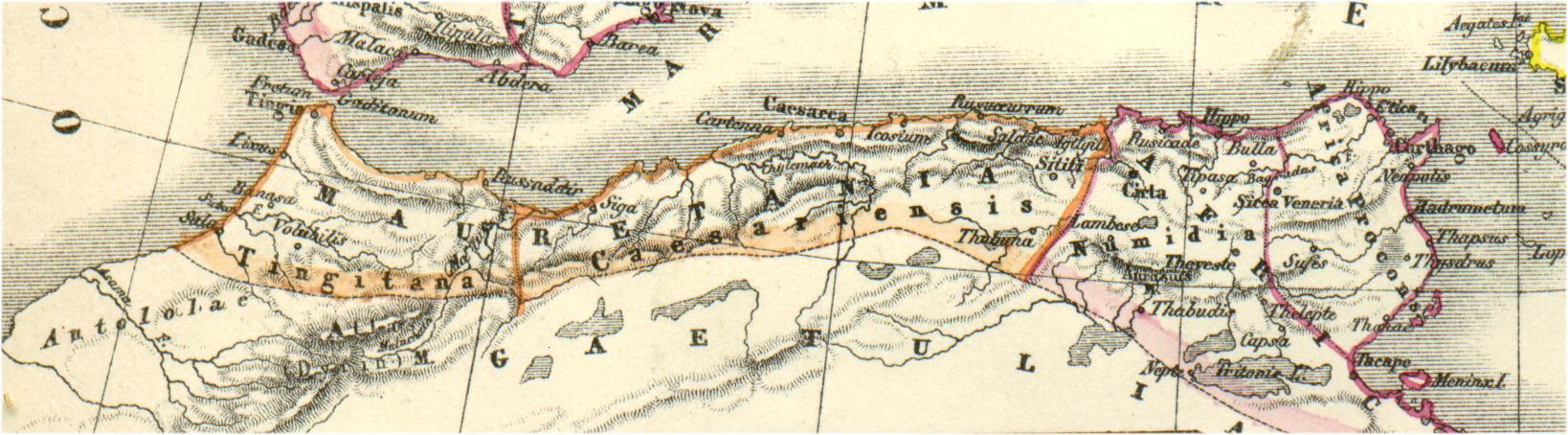
Bron: http://www.gottwein.de/latine/map/imp01_afr_nw.jpg
Autor: H.Kiepert, Atlas antiquus, Berlin (Reimer) o.J.
Liċenzja
|
This work is in the public domain in its country of origin and other countries and areas where the copyright term is the author's life plus 70 years or fewer.
| |
| This file has been identified as being free of known restrictions under copyright law, including all related and neighboring rights. | |
Kronoloġija tal-fajl
Agħfas fuq il-grupp data/ħin biex tara l-fajl biex tara kif jidher dak il-ħin.
| Data/Ħin | Minjatura | Qisien | Utent | Kumment | |
|---|---|---|---|---|---|
| kurrenti | 16:54, 3 Jannar 2011 | 3,509 × 1,383 (494 KB) | Profburp | Meilleure définition. Extrait de la carte: Hispania, Mauretania et Africa. (with) Carthago. (with) Provinciae Carthaginiensibus subditae. Auctore Henrico Kiepert Berolinensi. Geographische Verlagshandlung Dietrich Reimer (Ernst Vohsen) Berlin, Wilhemlstr | |
| 18:23, 13 Mejju 2006 | 1,638 × 454 (175 KB) | Rodriguillo | {{nl|Uit: H.Kiepert, Atlas antiquus, Berlin (Reimer) o.J. Bron: http://www.gottwein.de/latine/map/imp01_afr_nw.jpg Kaart met de ''provinciae'' Mauretania Tingitana, Mauretania Caesariensis en Numidia.}} {{es|Mapa de las provincias roman |
Użu tal-fajl
L-użu globali tal-fajl
Il-wikis segwenti jużaw dan il-fajl:
- Użu fuq am.wikipedia.org
- Użu fuq ar.wikipedia.org
- Użu fuq ary.wikipedia.org
- Użu fuq ast.wikipedia.org
- Użu fuq azb.wikipedia.org
- Użu fuq az.wikipedia.org
- Użu fuq be.wikipedia.org
- Użu fuq br.wikipedia.org
- Użu fuq ca.wikipedia.org
- Użu fuq ckb.wikipedia.org
- Użu fuq cs.wikipedia.org
- Użu fuq cy.wikipedia.org
- Użu fuq de.wikipedia.org
- Użu fuq en.wikipedia.org
- Użu fuq eo.wikipedia.org
- Użu fuq es.wikipedia.org
Ara l-użu globali ta' dan il-fajl.