Stampa:Map of Danish Settlements in India (1620 - 1845).svg

Size of this PNG preview of this SVG file: 512 × 446 pixels. Riżoluzzjonijiet oħra: 276 × 240 pixels | 551 × 480 pixels | 882 × 768 pixels | 1,176 × 1,024 pixels | 2,351 × 2,048 pixels
Fajl oriġinali (Fajl fil-format SVG, dimensjoni nominali 512 × 446 pixel, dimensjoni tal-fajl: 162 KB)
| Dan huwa fajl mill-Wikimedia Commons. Il-deskrizzjoni fuq il-paġna ta' diskussjoni oriġinali tidher hawn taħt.
|
.svg)
Taqsira
| Deskrizzjoni |
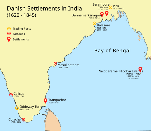
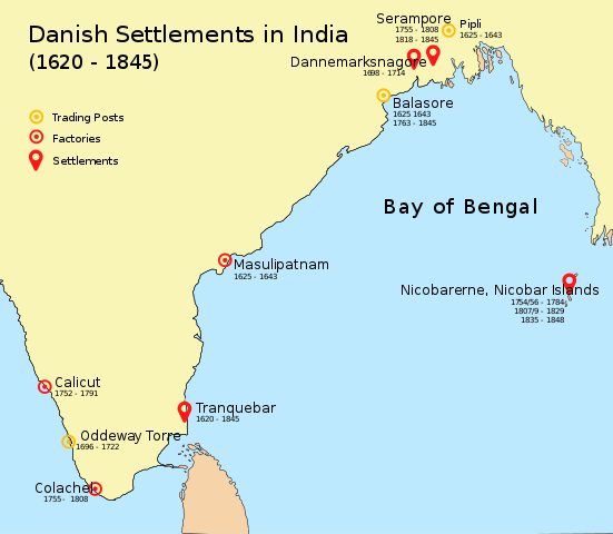
English: Map of Danish settlements and trading posts in India from 1620 - 1845 |
| Data | |
| Sors | Created using illustrator |
| Awtur | Adondai |
| Dan il-fajl huwa disponibbli taħt it-termini tal-liċenzja Creative Commons CC0 1.0 Universal | |
| The person who associated a work with this deed has dedicated the work to the public domain by waiving all of their rights to the work worldwide under copyright law, including all related and neighboring rights, to the extent allowed by law. You can copy, modify, distribute and perform the work, even for commercial purposes, all without asking permission.
|
Liċenzja
| I, the copyright holder of this work, release this work into the public domain. This applies worldwide. In some countries this may not be legally possible; if so: I grant anyone the right to use this work for any purpose, without any conditions, unless such conditions are required by law. |
Kronoloġija tal-fajl
Agħfas fuq il-grupp data/ħin biex tara l-fajl biex tara kif jidher dak il-ħin.
| Data/Ħin | Minjatura | Qisien | Utent | Kumment | |
|---|---|---|---|---|---|
| kurrenti | 09:07, 7 Mejju 2018 | | 512 × 446 (162 KB) | Adondai | {{subst:Upload marker added by en.wp UW}} {{Information |Description = {{en|Map of Danish settlements and trading posts in India from 1620 - 1845}} |Source = Created using illustrator |Date = 2018-05-07 |Author = Adondai }} {{cc-zero}} |
Użu tal-fajl
Il-4 paġni segwenti jwasslu għal din l-istampa:
L-użu globali tal-fajl
Il-wikis segwenti jużaw dan il-fajl:
- Użu fuq ar.wikipedia.org
- Użu fuq bn.wikipedia.org
- Użu fuq de.wikipedia.org
- Użu fuq en.wikipedia.org
- Użu fuq en.wikivoyage.org
- Użu fuq es.wikipedia.org
- Użu fuq fr.wikipedia.org
- Użu fuq he.wikipedia.org
- Użu fuq id.wikipedia.org
- Użu fuq it.wikipedia.org
- Użu fuq ja.wikipedia.org
- Użu fuq nl.wikipedia.org
- Użu fuq vi.wikipedia.org
- Użu fuq www.wikidata.org
- Użu fuq wuu.wikipedia.org
- Użu fuq zh.wikipedia.org
.svg)