Stampa:John Smith 1624 map of Bermuda with Forts 01.jpg

Daqs tad-dehra proviżorja: 766 × 600 pixels. Riżoluzzjonijiet oħra: 307 × 240 pixels | 613 × 480 pixels | 981 × 768 pixels | 1,280 × 1,003 pixels | 1,370 × 1,073 pixels
Fajl oriġinali (1,370 × 1,073 pixel, dimensjoni: 1.39 MB, tip ta' MIME: image/jpeg)
| Dan huwa fajl mill-Wikimedia Commons. Il-deskrizzjoni fuq il-paġna ta' diskussjoni oriġinali tidher hawn taħt.
|
Taqsira
| Deskrizzjoni |
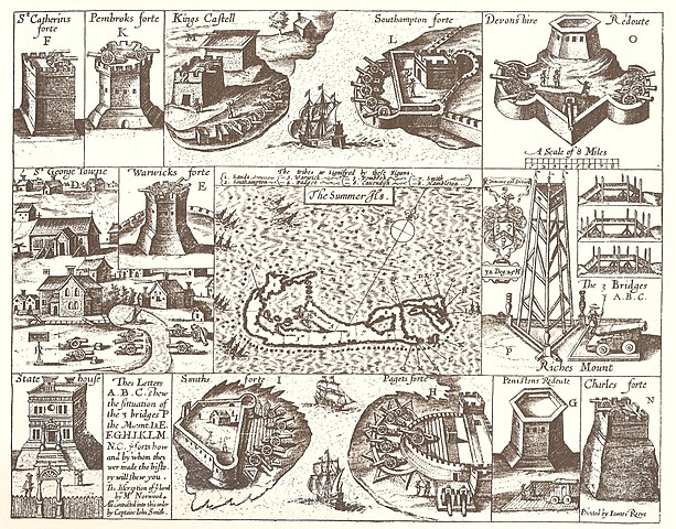
English: 1624 Map of Bermuda, with illustrations of fortifications and importand sites, including St. George's, Bermuda (the town), the State House, Bermuda, and the Castle Islands Fortifications, Bermuda |
| Data | |
| Sors | The Generall Historie of Virginia, New-England, and the Summer Isles, by Captain John Smith of Jamestown, printed by I.D and I. H. for Michael Sparkes, 1624. Other editions 1625, 1626, 1627, 1631, and 1632. |
| Awtur | Printed by James Reeve |
Liċenzja
|
This work is in the public domain in its country of origin and other countries and areas where the copyright term is the author's life plus 100 years or fewer. | |
| This file has been identified as being free of known restrictions under copyright law, including all related and neighboring rights. | |
| Annotations | This image is annotated: View the annotations at Commons |
Kronoloġija tal-fajl
Agħfas fuq il-grupp data/ħin biex tara l-fajl biex tara kif jidher dak il-ħin.
| Data/Ħin | Minjatura | Qisien | Utent | Kumment | |
|---|---|---|---|---|---|
| kurrenti | 17:39, 10 Frar 2008 | | 1,370 × 1,073 (1.39 MB) | Aodhdubh | {{Information |Description=1624 Map of Bermuda, with illustrations of fortifications and importand sites, including St. George's Town, the State House, and the [[Castle Islands Fortifications, Bermuda |
Użu tal-fajl
Il-2 paġni segwenti jwasslu għal din l-istampa:
L-użu globali tal-fajl
Il-wikis segwenti jużaw dan il-fajl:
- Użu fuq ar.wikipedia.org
- Użu fuq en.wikipedia.org
- Church of England
- Militia
- History of Bermuda
- Military of Bermuda
- John Smith (explorer)
- Fortification
- Robert Rich, 2nd Earl of Warwick
- Sea Venture
- Coastal artillery
- William Sayle
- County surveyor
- Bermuda Militia (1612–1815)
- Bermuda Militia (1612–1687)
- List of World Heritage Sites in the United Kingdom
- Architecture of Bermuda
- Castle Islands Fortifications, Bermuda
- State House, Bermuda
- Militia (England)
- English overseas possessions in the Wars of the Three Kingdoms
- St. Peter's Church, St. George's
- Coastal defence and fortification
- Bermuda Garrison
- User:DadrianT,Esq/County Surveyor draft page
- Fort St. Catherine
- Historic Town of St George and Related Fortifications, Bermuda
- Militia (British Empire)
- Fort George, Bermuda
- Użu fuq fi.wikipedia.org
- Użu fuq fr.wikipedia.org
- Użu fuq gl.wikipedia.org
- Użu fuq he.wikipedia.org
- Użu fuq hy.wikipedia.org
- Użu fuq id.wikipedia.org
- Użu fuq lv.wikipedia.org
- Użu fuq ms.wikipedia.org
- Użu fuq pl.wikipedia.org
- Użu fuq pt.wikipedia.org
- Użu fuq ru.wikipedia.org
- Użu fuq simple.wikipedia.org
- Użu fuq uk.wikipedia.org
- Użu fuq vi.wikipedia.org
- Użu fuq zh.wikipedia.org