Stampa:Jian'an Commanderies.png
Daqs tad-dehra proviżorja: 800 × 576 pixels. Riżoluzzjonijiet oħra: 320 × 230 pixels | 640 × 461 pixels | 1,024 × 737 pixels | 1,280 × 922 pixels | 2,500 × 1,800 pixels
Fajl oriġinali (2,500 × 1,800 pixel, dimensjoni: 5.28 MB, tip ta' MIME: image/png)
| Dan huwa fajl mill-Wikimedia Commons. Il-deskrizzjoni fuq il-paġna ta' diskussjoni oriġinali tidher hawn taħt.
|
Taqsira

|
File:Jian'an Commanderies.svg is a vector version of this file. It should be used in place of this PNG file when not inferior.
File:Jian'an Commanderies.png → File:Jian'an Commanderies.svg
For more information, see Help:SVG. |
 |
| Deskrizzjoni |
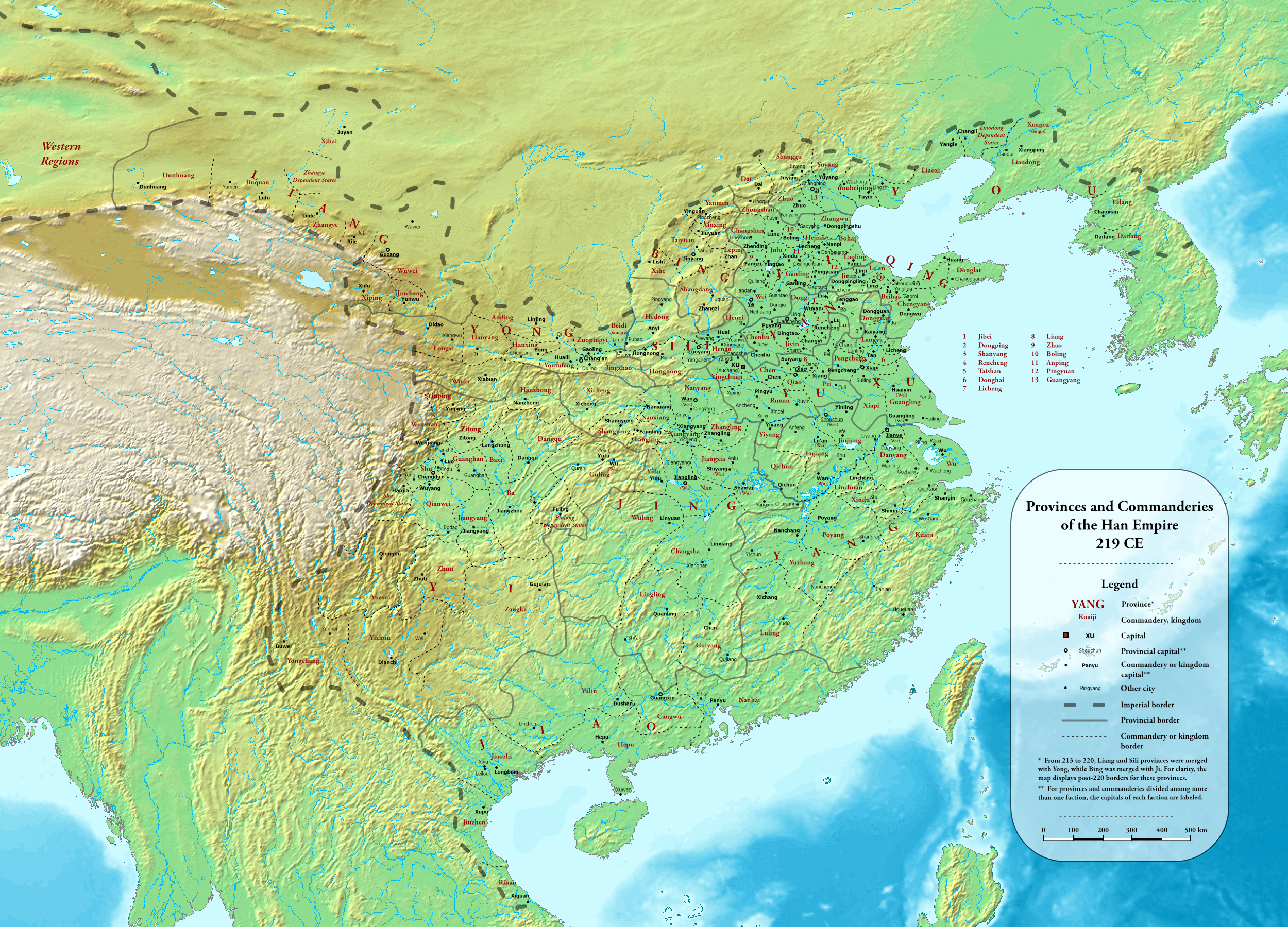
English: Provinces and commanderies of the Han Dynasty in 219 CE, during the Jian'an era
中文(简体):东汉建安时期州郡地图(建安二十四年,公元219年) |
| Data | |
| Sors |
Own work using:
|
| Awtur | Esiymbro |
Liċenzja
Jiena, id-detentur tal-copyright ta' dan ix-xogħol, niddikjara li se nippubblikah taħt il-liċenzja segwenti:
This file is licensed under the Creative Commons Attribution-Share Alike 4.0 International license.
- Inti ħieles:
- li taqsam – li tikkopja, tiddistribwixxi u tittrażmetti din l-opra
- li timmodifika – li tadatta l-biċċa xogħol
- Taħt il-kundizzjonijiet segwenti:
- attribuzzjoni – Għandek tattribwixxi x-xogħol bil-mod speċifikat mill-awtur jew minn min ta l-l-iċenzja (imma mhux b'xi mod li jissuġġerixxi ji jappoġjaw lilek jew l-użu tax-xogħol).
- Ixxerja bl-istess mod – Jekk tbiddel, tittrasforma jew tibni fuq dan il-materjal, inti għandek bżonn taqsam il-kontribuzzjonijiet tiegħek taħt l-istess liċenzja jew waħda li taqbel ma' dik oriġinali.
Kronoloġija tal-fajl
Agħfas fuq il-grupp data/ħin biex tara l-fajl biex tara kif jidher dak il-ħin.
| Data/Ħin | Minjatura | Qisien | Utent | Kumment | |
|---|---|---|---|---|---|
| kurrenti | 01:54, 20 Mejju 2022 | | 2,500 × 1,800 (5.28 MB) | Esiymbro | Corrections and more details |
| 16:22, 18 Mejju 2022 |  | 2,500 × 1,800 (5.28 MB) | Esiymbro | DS borders; other corrections | |
| 15:31, 21 Marzu 2022 |  | 2,500 × 1,800 (5.28 MB) | Esiymbro | Correcting a name; rewording legend notes | |
| 06:43, 14 Lulju 2020 |  | 2,500 × 1,800 (5.28 MB) | Esiymbro | Corrections and more details | |
| 03:22, 12 Lulju 2020 |  | 2,500 × 1,800 (5.28 MB) | Esiymbro | Corrections and more details | |
| 02:13, 10 Lulju 2020 |  | 2,500 × 1,800 (5.25 MB) | Esiymbro | {{Information |description ={{en|1=Provinces and commanderies of the Han Dynasty in 219 CE, during the Jian'an era}} {{zh|1=东汉建安时期州郡地图(建安二十四年,公元219年)}} |date =2020-07-10 |source ={{own}} |author =User:Esiymbro }} Category:Maps of the Han Dynasty Category:Maps of the Three Kingdoms |
Użu tal-fajl
Il-Paġna segwenti twassal għal din l-istampa:
L-użu globali tal-fajl
Il-wikis segwenti jużaw dan il-fajl:
- Użu fuq en.wikipedia.org
- Użu fuq es.wikipedia.org
- Użu fuq ko.wikipedia.org
- Użu fuq ms.wikipedia.org
- Użu fuq nn.wikipedia.org
- Użu fuq pl.wikipedia.org
- Użu fuq sl.wikipedia.org
- Użu fuq sq.wikipedia.org
- Użu fuq th.wikipedia.org
- Użu fuq uk.wikipedia.org
- Użu fuq vi.wikipedia.org