Stampa:Gulf of Izmit, Turkey.JPG

Daqs tad-dehra proviżorja: 800 × 532 pixels. Riżoluzzjonijiet oħra: 320 × 213 pixels | 640 × 425 pixels | 1,024 × 681 pixels | 1,280 × 851 pixels | 2,560 × 1,701 pixels | 4,288 × 2,850 pixels
Fajl oriġinali (4,288 × 2,850 pixel, dimensjoni: 2.6 MB, tip ta' MIME: image/jpeg)
| Dan huwa fajl mill-Wikimedia Commons. Il-deskrizzjoni fuq il-paġna ta' diskussjoni oriġinali tidher hawn taħt.
|
Taqsira
| Deskrizzjoni |
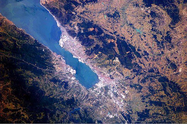
English: This astronaut photograph highlights the metropolitan area of Izmit along the northern and eastern shores of the Sea of Marmara, at the end of the Gulf of Izmit. Commercial and industrial centres—including petroleum refineries and automobile factories—are recognizable by large structures with white rooftops. The smaller city of Gölcük on the southern shoreline of the Gulf is the location of a Turkish naval facility and another automobile factory. Both urban areas are built primarily on flat lowlands adjacent to the Gulf, with green vegetation marking highland areas to the north of Izmit and south of Gölcük. |
| Data | |
| Sors | NASA Earth Observatory |
| Awtur | ISS Expedition 24 crew |
| Camera location | | View this and other nearby images on: OpenStreetMap |
|---|
This image or video was catalogued by Johnson Space Center of the United States National Aeronautics and Space Administration (NASA) under Photo ID: ISS024-E-10162. This tag does not indicate the copyright status of the attached work. A normal copyright tag is still required. See Commons:Licensing. Other languages:
|
Image acquired with a Nikon D2Xs digital camera using a 180 mm lens, and is provided by the ISS Crew Earth Observations experiment and Image Science & Analysis Laboratory, Johnson Space Center.
Liċenzja
| This file is in the public domain in the United States because it was solely created by NASA. NASA copyright policy states that "NASA material is not protected by copyright unless noted". (See Template:PD-USGov, NASA copyright policy page or JPL Image Use Policy.) | ||
 |
Warnings:
|
Kronoloġija tal-fajl
Agħfas fuq il-grupp data/ħin biex tara l-fajl biex tara kif jidher dak il-ħin.
| Data/Ħin | Minjatura | Qisien | Utent | Kumment | |
|---|---|---|---|---|---|
| kurrenti | 09:56, 23 Awwissu 2010 | | 4,288 × 2,850 (2.6 MB) | Originalwana | {{Information |Description={{en|1=This astronaut photograph highlights the metropolitan area of Izmit along the northern and eastern shores of the Sea of Marmara, at the end of the Gulf of Izmit. [[:Category:Commerc |
Użu tal-fajl
Il-Paġna segwenti twassal għal din l-istampa:
L-użu globali tal-fajl
Il-wikis segwenti jużaw dan il-fajl:
- Użu fuq ar.wikipedia.org
- Użu fuq az.wikipedia.org
- Użu fuq ba.wikipedia.org
- Użu fuq bg.wikipedia.org
- Użu fuq bn.wikipedia.org
- Użu fuq ca.wikipedia.org
- Użu fuq ceb.wikipedia.org
- Użu fuq cs.wikipedia.org
- Użu fuq en.wikipedia.org
- Użu fuq es.wikipedia.org
- Użu fuq eu.wikipedia.org
- Użu fuq fa.wikipedia.org
- Użu fuq fr.wikipedia.org
- Użu fuq he.wikipedia.org
- Użu fuq hr.wikipedia.org
- Użu fuq id.wikipedia.org
- Użu fuq ilo.wikipedia.org
- Użu fuq it.wikipedia.org
- Użu fuq ka.wikipedia.org
- Użu fuq nl.wikipedia.org
- Użu fuq nn.wikipedia.org
- Użu fuq ru.wikipedia.org
- Użu fuq tr.wikipedia.org
- Użu fuq tr.wikivoyage.org
- Użu fuq www.wikidata.org
- Użu fuq zh.wikipedia.org