Stampa:French Algeria evolution 1830-1962 map-fr.svg

Size of this PNG preview of this SVG file: 604 × 600 pixels. Riżoluzzjonijiet oħra: 242 × 240 pixels | 483 × 480 pixels | 773 × 768 pixels | 1,031 × 1,024 pixels | 2,062 × 2,048 pixels | 1,287 × 1,278 pixels
Fajl oriġinali (Fajl fil-format SVG, dimensjoni nominali 1,287 × 1,278 pixel, dimensjoni tal-fajl: 1.86 MB)
| Dan huwa fajl mill-Wikimedia Commons. Il-deskrizzjoni fuq il-paġna ta' diskussjoni oriġinali tidher hawn taħt.
|
Taqsira
| Deskrizzjoni |
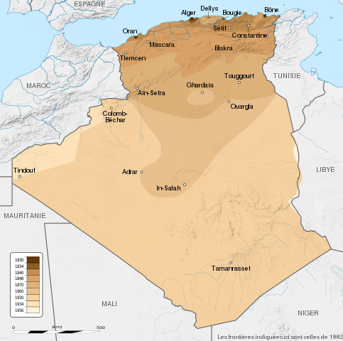
English: French Algeria evolution map, from 1830 to 1962.
Français : Carte montrant l'évolution territoriale de l'Algérie française, de 1830 à 1962.
|
| Data | (UTC) |
| Sors |
English:
Français :
|
| Awtur | Sémhur |
| Verżjonijiet oħra |
Derivative works of this file: French Algeria evolution 1830-1962 map-es.svg |
| Attribuzzjoni (required by the license) | © Sémhur / Wikimedia Commons / |
| SVG genesis |
| Camera location | | View this and other nearby images on: OpenStreetMap |
|---|
Liċenzja
Jiena, id-detentur tal-copyright ta' dan ix-xogħol, niddikjara li se nippubblikah taħt il-liċenzji segwenti:
| Copyleft: This work of art is free; you can redistribute it and/or modify it according to terms of the Free Art License. You will find a specimen of this license on the Copyleft Attitude site as well as on other sites. |
This file is licensed under the Creative Commons Attribution-Share Alike Attribution-Share Alike 4.0 International, 3.0 Unported, 2.5 Generic, 2.0 Generic and 1.0 Generic license.
- Inti ħieles:
- li taqsam – li tikkopja, tiddistribwixxi u tittrażmetti din l-opra
- li timmodifika – li tadatta l-biċċa xogħol
- Taħt il-kundizzjonijiet segwenti:
- attribuzzjoni – Għandek tattribwixxi x-xogħol bil-mod speċifikat mill-awtur jew minn min ta l-l-iċenzja (imma mhux b'xi mod li jissuġġerixxi ji jappoġjaw lilek jew l-użu tax-xogħol).
- Ixxerja bl-istess mod – Jekk tbiddel, tittrasforma jew tibni fuq dan il-materjal, inti għandek bżonn taqsam il-kontribuzzjonijiet tiegħek taħt l-istess liċenzja jew waħda li taqbel ma' dik oriġinali.
Tista' tagħżel il-liċenzja li tippreferi.
Original upload log
This image is a derivative work of the following images:
- File:Algeria_location_map.svg licensed with Cc-by-sa-3.0, GFDL
- 2009-11-17T12:51:26Z Sting 1287x1278 (372657 Bytes) == {{int:filedesc}} == {{Location|28|19|00|N|1|39|00|E|scale:8000000}} {{Information |Description={{en|Blank administrative map of [[:en:Algeria|Algeria]], for geo-location purposes.}} {{fr|Carte administrative vierge de l'[
Uploaded with derivativeFX
Kronoloġija tal-fajl
Agħfas fuq il-grupp data/ħin biex tara l-fajl biex tara kif jidher dak il-ħin.
| Data/Ħin | Minjatura | Qisien | Utent | Kumment | |
|---|---|---|---|---|---|
| kurrenti | 19:34, 22 Mejju 2014 | | 1,287 × 1,278 (1.86 MB) | Sémhur | Valid SVG |
| 18:57, 29 Settembru 2012 |  | 1,287 × 1,278 (1.86 MB) | Sémhur | == {{int:filedesc}} == {{Information |Description={{Multilingual description |en= en:French Algeria evolution map, from 1830 to 1962. |fr= Carte de l'fr:Algérie française, de 1830 à 1962. }} <br/> Scale: 1:6,800,000 (precision: 1,700 m)... |
Użu tal-fajl
Il-Paġna segwenti twassal għal din l-istampa:
L-użu globali tal-fajl
Il-wikis segwenti jużaw dan il-fajl:
- Użu fuq ast.wikipedia.org
- Użu fuq bg.wikipedia.org
- Użu fuq ca.wikipedia.org
- Użu fuq da.wikipedia.org
- Użu fuq de.wikipedia.org
- Użu fuq en.wikipedia.org
- Użu fuq eu.wikipedia.org
- Użu fuq fa.wikipedia.org
- Użu fuq fi.wikipedia.org
- Użu fuq fr.wikipedia.org
- Użu fuq ga.wikipedia.org
- Użu fuq hy.wikipedia.org
- Użu fuq id.wikipedia.org
- Użu fuq it.wikipedia.org
- Użu fuq ja.wikipedia.org
- Użu fuq ka.wikipedia.org
- Użu fuq ko.wikipedia.org
- Użu fuq lt.wikipedia.org
- Użu fuq lv.wikipedia.org
- Użu fuq mk.wikipedia.org
- Użu fuq ms.wikipedia.org
- Użu fuq nl.wikipedia.org
- Użu fuq pl.wikipedia.org
- Użu fuq pnb.wikipedia.org
- Użu fuq pt.wikipedia.org
- Użu fuq ro.wikipedia.org
- Użu fuq ru.wikipedia.org
Ara l-użu globali ta' dan il-fajl.