Stampa:CarthageMap.png
Mhux disponibli verżjonijiet b'risoluzzjoni akbar.
CarthageMap.png (770 × 447 pixel, dimensjoni: 106 KB, tip ta' MIME: image/png)
| Dan huwa fajl mill-Wikimedia Commons. Il-deskrizzjoni fuq il-paġna ta' diskussjoni oriġinali tidher hawn taħt.
|
Taqsira
| Deskrizzjoni |
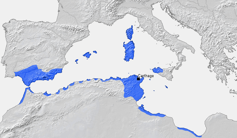
Location of Carthage and Carthaginian sphere of influence prior to the First Punic War (264 BC) Source: Self-made, based on Putzger Atlas und Chronik zur Weltgeschichte, Berlin, 2002 Template: [1] Author: BishkekRocks |
||
| Data | 18 Marzu 2006 (original upload date) | ||
| Sors | No machine-readable source provided. Own work assumed (based on copyright claims). | ||
| Awtur | No machine-readable author provided. BishkekRocks assumed (based on copyright claims). | ||
| Verżjonijiet oħra |
|

Liċenzja
| I, the copyright holder of this work, release this work into the public domain. This applies worldwide. In some countries this may not be legally possible; if so: I grant anyone the right to use this work for any purpose, without any conditions, unless such conditions are required by law. |
Kronoloġija tal-fajl
Agħfas fuq il-grupp data/ħin biex tara l-fajl biex tara kif jidher dak il-ħin.
| Data/Ħin | Minjatura | Qisien | Utent | Kumment | |
|---|---|---|---|---|---|
| kurrenti | 19:50, 6 April 2023 | | 770 × 447 (106 KB) | Titanjs | Reverted to version as of 15:31, 18 March 2006 (UTC) |
| 14:16, 23 Marzu 2016 |  | 770 × 447 (288 KB) | Michczu | drobna poprawka | |
| 16:52, 19 Settembru 2014 |  | 770 × 447 (128 KB) | Daygum | True areas occupied by chartaginians | |
| 15:31, 18 Marzu 2006 |  | 770 × 447 (106 KB) | BishkekRocks | Location of Carthage and Carthaginian influence sphere before the First Punic War (264 BC) Source: Self-made, based on Putzger Atlas und Chronik zur Weltgeschichte, Berlin, 2002 Template: [http://www.demis.nl/wms/mapclip.htm] Author: ~~~ [[Category:Ca |
Użu tal-fajl
L-użu globali tal-fajl
Il-wikis segwenti jużaw dan il-fajl:
- Użu fuq ar.wikipedia.org
- Użu fuq ast.wikipedia.org
- Użu fuq azb.wikipedia.org
- Użu fuq az.wikipedia.org
- Użu fuq ba.wikipedia.org
- Użu fuq be-tarask.wikipedia.org
- Użu fuq bg.wikipedia.org
- Użu fuq bm.wikipedia.org
- Użu fuq br.wikipedia.org
- Użu fuq bs.wikipedia.org
- Użu fuq ca.wikipedia.org
- Użu fuq cdo.wikipedia.org
- Użu fuq cs.wikipedia.org
- Użu fuq de.wikipedia.org
- Użu fuq el.wikipedia.org
- Użu fuq en.wikipedia.org
- Użu fuq eo.wikipedia.org
- Użu fuq es.wikipedia.org
Ara l-użu globali ta' dan il-fajl.