Stampa:Bermuda wv.jpg
Mhux disponibli verżjonijiet b'risoluzzjoni akbar.
Bermuda_wv.jpg (800 × 600 pixel, dimensjoni: 335 KB, tip ta' MIME: image/jpeg)
| Dan huwa fajl mill-Wikimedia Commons. Il-deskrizzjoni fuq il-paġna ta' diskussjoni oriġinali tidher hawn taħt.
|
Taqsira
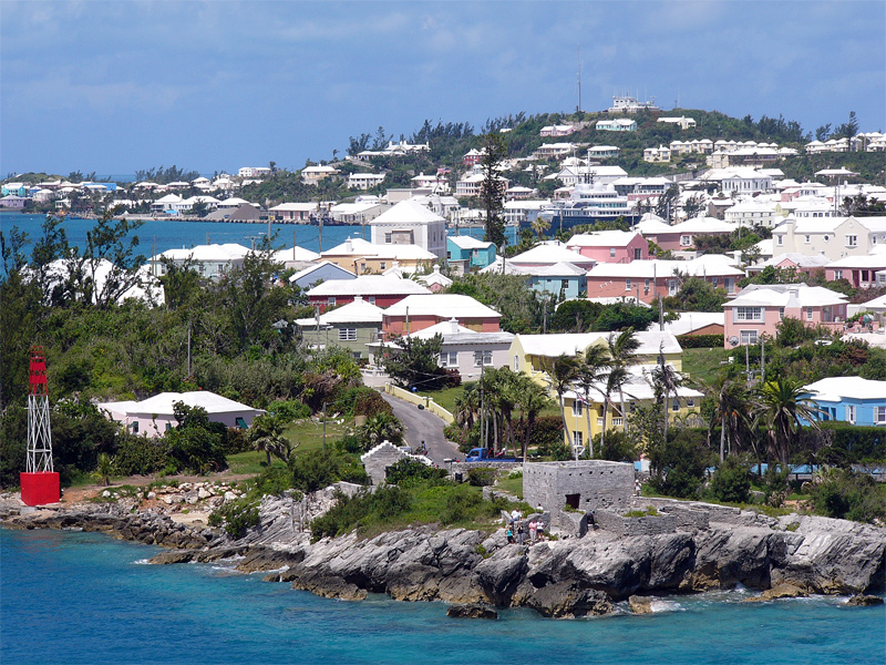
| Deskrizzjoni |
English: Residential suburb near the old St. George's Garrison, with "Town Cut Battery" or "Gate's Fort" in the foreground (with Cut Road behind it), on the northern side of the Town Cut shipping channel, and St. George's Town and harbour in the background, with Fort George on the peak of Mount Hill beyond, and a small ship is visible docked at Ordnance Island, off the town square]].
The Town Cut had been a minor channel, suitable only for small vessels to enter or exit the harbour, until dredged before the First World War. Before then, larger vessels had used the St. George's Channel between Paget Island and Governor's Island, which was watched over by Fort Paget (on Paget Island) and Smith's Fort (on Governor's Island). In the 19th Century, Fort Cunningham was erected on Paget Island, making all three of the earlier batteries redundant. Alexandra Battery (at Building Bay on St. George's Island, immediately to the north of Cut Battery) and St. David's Battery on St. David's Island were later added (there were also three other forts armed with coastal artillery batteries to the North-West of Building Bay: Fort St. Catherine's at St. Catherine's Point, and Fort Victoria and Fort Albert on Retreat Hill, to its rear). St. George's Town and the various forts and related military installations at the East End of Bermuda are together a United Nations Educational, Scientific and Cultural Organization's (UNESCO) World Heritage Site, the Historic Town of St George and Related Fortifications, Bermuda.[1][2] |
| Data | 24 Awwissu 2006 (original upload date) |
| Sors | Opra proprja |
| Awtur | (WT-en) Legrospaumé at Ingliż Wikivoyage |
| Camera location | | View this and other nearby images on: OpenStreetMap |
|---|
References
- ↑ Bermuda Forts 1612–1957, Dr. Edward C. Harris, The Bermuda Maritime Museum Press, The Bermuda Maritime Museum, P.O. Box MA 133, Mangrove Bay, Bermuda MA BX, ISBN 0-921560-11-7
- ↑ UNESCO World Heritage Centre: Historic Town of St George and Related Fortifications, Bermuda
Liċenzja
| This work has been released into the public domain by its author, (WT-en) Legrospaumé at Ingliż Wikivoyage. This applies worldwide. In some countries this may not be legally possible; if so: (WT-en) Legrospaumé at Ingliż Wikivoyage grants anyone the right to use this work for any purpose, without any conditions, unless such conditions are required by law.
|
Original upload log
| This file was imported from Wikivoyage en. |
The original description page was here. All following user names refer to en.wikivoyage-old.
- 2006-08-24 12:07 (WT-en) Legrospaumé 800×600 (343391 bytes) Bermuda (Import from wikitravel.org/en)
Kronoloġija tal-fajl
Agħfas fuq il-grupp data/ħin biex tara l-fajl biex tara kif jidher dak il-ħin.
| Data/Ħin | Minjatura | Qisien | Utent | Kumment | |
|---|---|---|---|---|---|
| kurrenti | 19:09, 8 Jannar 2013 | | 800 × 600 (335 KB) | MGA73bot2 | {{BotMoveToCommons|en.oldwikivoyage|year={{subst:CURRENTYEAR}}|month={{subst:CURRENTMONTHNAME}}|day={{subst:CURRENTDAY}}}} == {{int:filedesc}} == {{Information |description=Bermuda |date={{Date|2006|8|24}} (original upload date) |source={{Own}}<BR />{{... |
Użu tal-fajl
Il-Paġna segwenti twassal għal din l-istampa:
L-użu globali tal-fajl
Il-wikis segwenti jużaw dan il-fajl:
- Użu fuq el.wikipedia.org
- Użu fuq en.wikipedia.org
- Użu fuq en.wikivoyage.org
- Użu fuq es.wikivoyage.org
- Użu fuq fi.wikipedia.org
- Użu fuq gl.wikipedia.org
- Użu fuq id.wikipedia.org
- Użu fuq ja.wikipedia.org
- Użu fuq nl.wikipedia.org
- Użu fuq pt.wikipedia.org
- Użu fuq simple.wikipedia.org
- Użu fuq vi.wikipedia.org
- Użu fuq vi.wikivoyage.org