Stampa:Aldabra islands seychelles 76.jpg

Daqs tad-dehra proviżorja: 800 × 353 pixels. Riżoluzzjonijiet oħra: 320 × 141 pixels | 847 × 374 pixels
Fajl oriġinali (847 × 374 pixel, dimensjoni: 70 KB, tip ta' MIME: image/jpeg)
| Dan huwa fajl mill-Wikimedia Commons. Il-deskrizzjoni fuq il-paġna ta' diskussjoni oriġinali tidher hawn taħt.
|
Taqsira
| Deskrizzjoni |
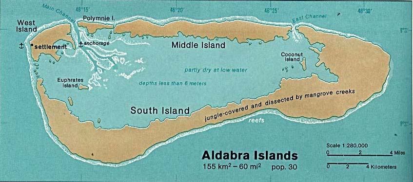
Deutsch: Karte des Aldabra-Atolls, Seychellen
English: Map of Aldabra Atoll, Outer Islands of Seychelles
Español: Mapa de Aldabra, Archipiélago de Seychelles |
| Data | |
| Sors | http://www.lib.utexas.edu/maps/islands_oceans_poles/aldabra_islands_76.jpg |
| Awtur | Taken from Perry-Castañeda Library (PCL), originally from CIA Indian Ocean Atlas |
Liċenzja
| This image is a work of a Central Intelligence Agency employee, taken or made as part of that person's official duties. As a Work of the United States Government, this image or media is in the public domain in the United States.
|

|
Kronoloġija tal-fajl
Agħfas fuq il-grupp data/ħin biex tara l-fajl biex tara kif jidher dak il-ħin.
| Data/Ħin | Minjatura | Qisien | Utent | Kumment | |
|---|---|---|---|---|---|
| kurrenti | 23:40, 30 Novembru 2005 | | 847 × 374 (70 KB) | Oxam Hartog | en : map(1976) by CIA of Aldabra atoll, Seychelles archipelago source : http://www.lib.utexas.edu/maps/islands_oceans_poles/aldabra_islands_76.jpg |
Użu tal-fajl
Il-Paġna segwenti twassal għal din l-istampa:
L-użu globali tal-fajl
Il-wikis segwenti jużaw dan il-fajl:
- Użu fuq af.wikipedia.org
- Użu fuq ast.wikipedia.org
- Użu fuq az.wikipedia.org
- Użu fuq ca.wikipedia.org
- Użu fuq da.wikipedia.org
- Użu fuq en.wikipedia.org
- Użu fuq eo.wikipedia.org
- Użu fuq es.wikipedia.org
- Użu fuq fr.wikipedia.org
- Użu fuq gl.wikipedia.org
- Użu fuq it.wikipedia.org
- Użu fuq ja.wikipedia.org
- Użu fuq ka.wikipedia.org
- Użu fuq ko.wikipedia.org
- Użu fuq lt.wikipedia.org
- Użu fuq nl.wikipedia.org
- Użu fuq no.wikipedia.org
- Użu fuq pl.wikipedia.org
- Użu fuq ru.wikipedia.org
- Użu fuq uk.wikipedia.org
- Użu fuq uz.wikipedia.org