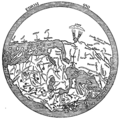
Stampa:Al-Idrisi's world map.JPG

Daqs tad-dehra proviżorja: 550 × 599 pixels. Riżoluzzjonijiet oħra: 220 × 240 pixels | 440 × 480 pixels | 705 × 768 pixels | 940 × 1,024 pixels | 1,424 × 1,552 pixels
Fajl oriġinali (1,424 × 1,552 pixel, dimensjoni: 917 KB, tip ta' MIME: image/jpeg)
Kronoloġija tal-fajl
Agħfas fuq il-grupp data/ħin biex tara l-fajl biex tara kif jidher dak il-ħin.
| Data/Ħin | Minjatura | Qisien | Utent | Kumment | |
|---|---|---|---|---|---|
| kurrenti | 03:53, 23 Awwissu 2006 |  | 1,424 × 1,552 (917 KB) | Leinad-Z~commonswiki | Losslessly rotaded and cropped from http://www.sindominio.net/labiblio/varios/IdrisiMap.jpg |
| 13:55, 8 April 2005 |  | 492 × 570 (72 KB) | EugeneZelenko | Al-Idrisi's world map from 1154. Note that south is at the top of the map. Originally uploaded to English Wikipedia by en:User: SimonP (06:19, 8 Dec 2004). {{PD}} |
Użu tal-fajl
Il-2 paġni segwenti jwasslu għal din l-istampa:
L-użu globali tal-fajl
Il-wikis segwenti jużaw dan il-fajl:
- Użu fuq als.wikipedia.org
- Użu fuq ar.wikipedia.org
- الإدريسي
- خرائطية
- الواق واق
- خريطة
- بوابة:علوم/صورة مختارة
- نزهة المشتاق في اختراق الآفاق
- بربرة (الصومال)
- مستخدم:Ibrahim.ID/سجل الأعمال
- ويكيبيديا:جائزة المنتج - النصف الأول لعام 2014/Ibrahim.ID
- ويكيبيديا:ترشيحات الصور المختارة/خريطة الإدريسي
- بوابة:جغرافيا/صورة مختارة/1
- بوابة:جغرافيا/صورة مختارة/أرشيف
- ويكيبيديا:صور مختارة/رسومات وجداول وخرائط/خرائط
- بوابة:التاريخ الإسلامي/صورة مختارة/أرشيف
- بوابة:التاريخ الإسلامي/صورة مختارة/7
- مستخدم:عبد المؤمن/مصور/تاريخ إسلامي
- ويكيبيديا:صورة اليوم المختارة/مايو 2016
- قالب:صورة اليوم المختارة/2016-05-10
- بوابة:علوم/صورة مختارة/11
- ويكيبيديا:صورة اليوم المختارة/يوليو 2017
- قالب:صورة اليوم المختارة/2017-07-26
- ويكيبيديا:صورة اليوم المختارة/يوليو 2019
- قالب:صورة اليوم المختارة/2019-07-05
- ويكيبيديا:صورة اليوم المختارة/مارس 2020
- قالب:صورة اليوم المختارة/2020-03-16
- مستخدم:Mounir Neddi
- ويكيبيديا:صورة اليوم المختارة/يناير 2023
- قالب:صورة اليوم المختارة/2023-01-15
- قالب:صورة اليوم المختارة/تخطيط/2023/يناير
- مستخدم:Mounir Neddi/الملف الشخصي/قسم إضافي علوي
- قالب:خبير في علم الخرائطية
- مستخدم:Bmt3s/ملعب/3
- Użu fuq ast.wikipedia.org
- Użu fuq be-tarask.wikipedia.org
- Użu fuq be.wikipedia.org
- Użu fuq bn.wikipedia.org
- Użu fuq br.wikipedia.org
- Użu fuq bs.wikipedia.org
- Użu fuq ca.wikipedia.org
- Użu fuq ckb.wikipedia.org
Ara l-użu globali ta' dan il-fajl.


