Stampa:Uruguay T2.png

Daqs tad-dehra proviżorja: 527 × 599 pixels. Riżoluzzjonijiet oħra: 211 × 240 pixels | 422 × 480 pixels | 691 × 786 pixels
Fajl oriġinali (691 × 786 pixel, dimensjoni: 1.18 MB, tip ta' MIME: image/png)
| Dan huwa fajl mill-Wikimedia Commons. Il-deskrizzjoni fuq il-paġna ta' diskussjoni oriġinali tidher hawn taħt.
|
Taqsira
| Deskrizzjoni |
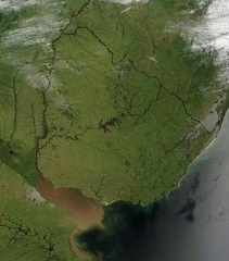
Español: Foto de Uruguay tomada desde satélite. Se aprecian claramente los límites con Brasil y Argentina, y el Río de la Plata al sur.
English: Photo of Uruguay taken from satellite, where the limits with Brazil and Argentina are clearly appreciated, as well as the Río de la Plata to the south. |
| Data | |
| Sors | http://visibleearth.nasa.gov/view_rec.php?id=4817 |
| Awtur | Jeff Schmaltz, MODIS Rapid Response Team, NASA/GSFC |
Liċenzja
| This file is in the public domain in the United States because it was solely created by NASA. NASA copyright policy states that "NASA material is not protected by copyright unless noted". (See Template:PD-USGov, NASA copyright policy page or JPL Image Use Policy.) | ||
 |
Warnings:
|
Kronoloġija tal-fajl
Agħfas fuq il-grupp data/ħin biex tara l-fajl biex tara kif jidher dak il-ħin.
| Data/Ħin | Minjatura | Qisien | Utent | Kumment | |
|---|---|---|---|---|---|
| kurrenti | 04:11, 29 Novembru 2004 | | 691 × 786 (1.18 MB) | Tano4595 | Uruguay_satelite |
Użu tal-fajl
Il-Paġna segwenti twassal għal din l-istampa:
L-użu globali tal-fajl
Il-wikis segwenti jużaw dan il-fajl:
- Użu fuq af.wikipedia.org
- Użu fuq als.wikipedia.org
- Użu fuq an.wikipedia.org
- Użu fuq ar.wikipedia.org
- Użu fuq ast.wikipedia.org
- Użu fuq azb.wikipedia.org
- Użu fuq ba.wikipedia.org
- Użu fuq bg.wikipedia.org
- Użu fuq ca.wikipedia.org
- Użu fuq cs.wikipedia.org
- Użu fuq da.wikipedia.org
- Użu fuq de.wikipedia.org
- Użu fuq el.wikipedia.org
- Użu fuq en.wikipedia.org
- Użu fuq en.wikibooks.org
- Użu fuq eo.wikipedia.org
- Użu fuq es.wikipedia.org
- Użu fuq eu.wikipedia.org
- Użu fuq fr.wikipedia.org
- Użu fuq gcr.wikipedia.org
- Użu fuq hi.wikipedia.org
- Użu fuq hr.wikipedia.org
- Użu fuq hu.wikipedia.org
- Użu fuq hy.wikipedia.org
- Użu fuq hyw.wikipedia.org
- Użu fuq is.wikipedia.org
- Użu fuq it.wikipedia.org
- Użu fuq ku.wikipedia.org
- Użu fuq la.wikipedia.org
- Użu fuq li.wikipedia.org
- Użu fuq lv.wikipedia.org
- Użu fuq ms.wikipedia.org
- Użu fuq oc.wikipedia.org
- Użu fuq os.wikipedia.org
- Użu fuq pcd.wikipedia.org
- Użu fuq pl.wikipedia.org
- Użu fuq pt.wikipedia.org
Ara l-użu globali ta' dan il-fajl.