Stampa:Union Pacific Railroad system map.svg

Size of this PNG preview of this SVG file: 800 × 457 pixels. Riżoluzzjonijiet oħra: 320 × 183 pixels | 640 × 366 pixels | 1,024 × 585 pixels | 1,280 × 731 pixels | 2,560 × 1,463 pixels | 1,400 × 800 pixels
Fajl oriġinali (Fajl fil-format SVG, dimensjoni nominali 1,400 × 800 pixel, dimensjoni tal-fajl: 1.56 MB)
| Dan huwa fajl mill-Wikimedia Commons. Il-deskrizzjoni fuq il-paġna ta' diskussjoni oriġinali tidher hawn taħt.
|
Taqsira
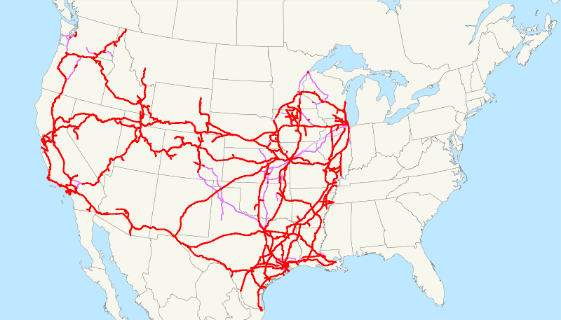
| Deskrizzjoni | This is a map of the Union Pacific Railroad as of 2008, with trackage rights in purple (the special Chicago-Kansas City intermodal trackage rights are lighter). Email me if you would like a copy of the GIS data I created (modified from Bureau of Transportation Statistics North American Transportation Atlas Data) or if you see any errors. |
| Data | 26 Awwissu 2008 (original upload date) |
| Sors | No machine-readable source provided. Own work assumed (based on copyright claims). |
| Awtur | No machine-readable author provided. NE2 assumed (based on copyright claims). |
Liċenzja
| I, the copyright holder of this work, release this work into the public domain. This applies worldwide. In some countries this may not be legally possible; if so: I grant anyone the right to use this work for any purpose, without any conditions, unless such conditions are required by law. |
Kronoloġija tal-fajl
Agħfas fuq il-grupp data/ħin biex tara l-fajl biex tara kif jidher dak il-ħin.
| Data/Ħin | Minjatura | Qisien | Utent | Kumment | |
|---|---|---|---|---|---|
| kurrenti | 04:52, 18 Marzu 2009 | | 1,400 × 800 (1.56 MB) | NE2 | Verifying that nothing has gotten screwed up. |
| 13:08, 23 Frar 2009 |  | 1,400 × 800 (1.54 MB) | NE2 | Changed the display of lines owned by the government for the purposes of passenger rail, so that if UP is the primary freight operator it is not shown as trackage rights. | |
| 11:03, 15 Jannar 2009 |  | 1,400 × 800 (1.51 MB) | NE2 | Just checking that I haven't lost any data over the months. | |
| 23:09, 26 Awwissu 2008 |  | 1,120 × 640 (1.47 MB) | NE2 | == Summary == This is a map of the Union Pacific Railroad as of 2008, with w:trackage rights in purple (the special Chicago-Kansas City intermodal trackage rights are lighter). Email me if you would like a copy of the GIS d |
Użu tal-fajl
Il-Paġna segwenti twassal għal din l-istampa:
L-użu globali tal-fajl
Il-wikis segwenti jużaw dan il-fajl:
- Użu fuq da.wikipedia.org
- Użu fuq de.wikipedia.org
- Użu fuq en.wikipedia.org
- Użu fuq eo.wikipedia.org
- Użu fuq es.wikipedia.org
- Użu fuq fa.wikipedia.org
- Użu fuq fi.wikipedia.org
- Użu fuq fr.wikipedia.org
- Użu fuq he.wikipedia.org
- Użu fuq hu.wikipedia.org
- Użu fuq id.wikipedia.org
- Użu fuq it.wikipedia.org
- Użu fuq ja.wikipedia.org
- Użu fuq ko.wikipedia.org
- Użu fuq ms.wikipedia.org
- Użu fuq nl.wikipedia.org
- Użu fuq no.wikipedia.org
- Użu fuq pl.wikipedia.org
- Użu fuq pt.wikipedia.org
- Użu fuq ro.wikipedia.org
- Użu fuq ru.wikipedia.org
- Użu fuq simple.wikipedia.org
- Użu fuq sk.wikipedia.org
- Użu fuq sv.wikipedia.org
- Użu fuq uk.wikipedia.org
- Użu fuq www.wikidata.org
- Użu fuq zh-min-nan.wikipedia.org
- Użu fuq zh.wikipedia.org