Stampa:RomanEmpire 117.svg

Size of this PNG preview of this SVG file: 512 × 376 pixels. Riżoluzzjonijiet oħra: 320 × 235 pixels | 640 × 470 pixels | 1,024 × 752 pixels | 1,280 × 940 pixels | 2,560 × 1,880 pixels
Fajl oriġinali (Fajl fil-format SVG, dimensjoni nominali 512 × 376 pixel, dimensjoni tal-fajl: 704 KB)
| Dan huwa fajl mill-Wikimedia Commons. Il-deskrizzjoni fuq il-paġna ta' diskussjoni oriġinali tidher hawn taħt.
|
Taqsira
| Deskrizzjoni |
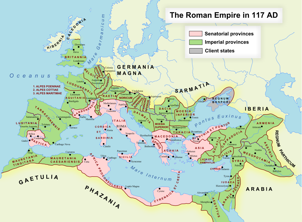
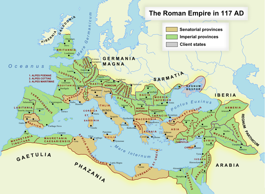
English: The maximum extent of the Roman Empire. Superimposed on a physical map. Senatorial Provinces Imperial Provinces Client States Español: Máxima extensión del Imperio Romano. Superpuesto en un mapa físico. Provincias Senatoriales Provincias Imperiales Estados satélite Deutsch: Das Römische Reich zur Zeit seiner maximalen Ausdehnung unter Trajan, 117 n. Chr. Senatorische Provinz Kaiserliche Provinz Klientelkönigtum Latina: Extentum maximum de Imperium Romanum. Provinciae senatus Provinciae Imperii Civitates Clientes 中文:公元117年图拉真在位时期罗马帝国的最大疆域。 元老院行省 元首行省 附庸国 日本語: ローマ帝国の最大版図。(西暦117年、皇帝トラヤヌス) 元老院属州 皇帝属州 従属国 |
| Data | 17 Ottubru 2005 (first version); 19 Diċembru 2007 (last version) |
| Sors | Transferred from en.wikipedia to Commons. |
| Awtur | ArdadN at Ingliż Wikipedija |
| Permess (Użu mill-ġdid tal-fajl) |
Public Domain |
| Verżjonijiet oħra |
[]
|
| SVG genesis |


SVG Support
This document is in the Scalable Vector Graphic format (SVG) and requires a supported browser (Firefox, Google Chrome, Opera) or a SVG plugin for Internet Explorer and other browsers. SVG is an open, text-based format, which means this map can be downloaded and modified/translated completely using a vector graphics editor like Adobe Illustrator or Inkscape (free) or a text editor such as Notepad.
| BLANK THUMBNAIL | View large PNG | View medium PNG | SVG Plugin for Internet Explorer and other browsers |
|---|---|---|---|
| Click here (purge cache) and then CTRL+F5 to reload. Help? | Try 1 Try 2 | Try 1 Try 2 | Adobe SVG plugin |
| Recommended browser | More Help | ||
| Firefox | List of SVG tools |
Liċenzja
ArdadN at Ingliż Wikipedija, id-detentur tal-copyright ta' dan ix-xogħol, jiddikjara li se jippubblikah taħt il-liċenzja segwenti:
| I, the copyright holder of this work, release this work into the public domain. This applies worldwide. In some countries this may not be legally possible; if so: I grant anyone the right to use this work for any purpose, without any conditions, unless such conditions are required by law. |
Kronoloġija tal-fajl
Agħfas fuq il-grupp data/ħin biex tara l-fajl biex tara kif jidher dak il-ħin.
| Data/Ħin | Minjatura | Qisien | Utent | Kumment | |
|---|---|---|---|---|---|
| kurrenti | 11:48, 24 Novembru 2022 | | 512 × 376 (704 KB) | Vikarna | alpes poeniae → alpes poeninae |
| 02:36, 2 Settembru 2021 |  | 512 × 376 (696 KB) | OgreBot | (BOT): Reverting to most recent version before archival | |
| 02:36, 2 Settembru 2021 |  | 2,180 × 1,600 (1.96 MB) | OgreBot | (BOT): Uploading old version of file from en.wikipedia; originally uploaded on 2008-12-10 00:59:00 by Andrein | |
| 02:36, 2 Settembru 2021 |  | 2,180 × 1,600 (1.96 MB) | OgreBot | (BOT): Uploading old version of file from en.wikipedia; originally uploaded on 2008-12-10 00:54:46 by Andrein | |
| 02:36, 2 Settembru 2021 |  | 2,180 × 1,600 (1.96 MB) | OgreBot | (BOT): Uploading old version of file from en.wikipedia; originally uploaded on 2008-12-10 00:22:12 by Andrein | |
| 02:36, 2 Settembru 2021 |  | 2,180 × 1,600 (1.94 MB) | OgreBot | (BOT): Uploading old version of file from en.wikipedia; originally uploaded on 2008-12-09 20:41:09 by Andrein | |
| 02:36, 2 Settembru 2021 |  | 2,180 × 1,600 (639 KB) | OgreBot | (BOT): Uploading old version of file from en.wikipedia; originally uploaded on 2008-09-18 15:26:52 by Andrein | |
| 02:35, 2 Settembru 2021 |  | 2,180 × 1,600 (639 KB) | OgreBot | (BOT): Uploading old version of file from en.wikipedia; originally uploaded on 2008-08-28 12:12:21 by Andrein | |
| 02:17, 2 Awwissu 2019 |  | 512 × 376 (696 KB) | Vikarna | there was a dot out of the map. | |
| 23:13, 30 Awwissu 2018 |  | 2,180 × 1,600 (1.11 MB) | Begoon | . |
Użu tal-fajl
Il-Paġna segwenti twassal għal din l-istampa:
L-użu globali tal-fajl
Il-wikis segwenti jużaw dan il-fajl:
- Użu fuq af.wikipedia.org
- Gallia Narbonensis
- Gallia Belgica
- Sjabloon:Romeinse provinsies 117 n.C.
- Gallia Aquitania
- Germania Inferior
- Germania Superior
- Thracië
- Kappadosië
- Lusitania (Romeinse provinsie)
- Koninkryk Iberië
- Epirus
- Osroene
- Wikipedia:Geselshoekie/Taalforum
- Britannia (provinsie)
- Dalmasië
- Numidië
- Achaea (Romeinse provinsie)
- Aegyptus (Romeinse provinsie)
- Africa (Romeinse provinsie)
- Alpes Cottiae
- Alpes Maritimae
- Alpes Poenninae
- Arabia Petraea
- Armenia Inferior
- Asia (Romeinse provinsie)
- Assyria (Romeinse provinsie)
- Bithynia (Romeinse provinsie)
- Cilicia
- Commagene
- Corsica et Sardinia
- Creta et Cyrenaica
- Dacia (Romeinse provinsie)
- Galatia (Romeinse provinsie)
- Gallia Lugdunensis
- Hispania Baetica
- Hispania Tarraconensis
- Italia (Romeinse Ryk)
- Iudaea (Romeinse provinsie)
- Lycaonia
- Lycia et Pamphylia
- Macedonia (Romeinse provinsie)
- Mauretania Caesariensis
- Mauretania Tingitana
- Moesia Superior
- Noricum
- Pannonia
- Pamphylia
- Pisidia
- Raetia
- Sicilia (Romeinse provinsie)
Ara l-użu globali ta' dan il-fajl.