Stampa:Pedro Teixeira Albernaz (1656) plano de Madrid.png

Daqs tad-dehra proviżorja: 800 × 508 pixels. Riżoluzzjonijiet oħra: 320 × 203 pixels | 640 × 406 pixels | 1,024 × 650 pixels | 1,280 × 813 pixels | 2,560 × 1,625 pixels | 3,823 × 2,427 pixels
Fajl oriġinali (3,823 × 2,427 pixel, dimensjoni: 19.29 MB, tip ta' MIME: image/png)
| Dan huwa fajl mill-Wikimedia Commons. Il-deskrizzjoni fuq il-paġna ta' diskussjoni oriġinali tidher hawn taħt.
|
_plano_de_Madrid.png)
Taqsira
| Deskrizzjoni |
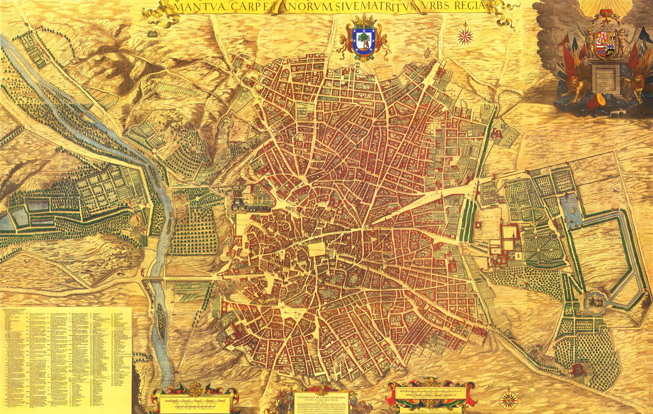
Español: Plano de la villa de Madrid dibujado por Pedro Teixeira Albernaz en 1656, por encargo de Felipe IV de España. Se identifican sus calles, plazas y edificios, muchos señalados con sus nombres. El plano está realizado en perspectiva caballera, de sur a norte. Está grabado en 20 planchas de 45x56 cm cada una, midiendo 2,85 x 1,80 metros, a una escala de 1:1.800. |
|||||||||||||||||||
| Data | ||||||||||||||||||||
| Sors | Mantua Carpetanorum sive Matritum Urbs Regia (Madrid Ciudad Regia) conocido como «el plano de Teixeira». | |||||||||||||||||||
| Awtur |
|
|||||||||||||||||||
| Permess (Użu mill-ġdid tal-fajl) |
PD-art/1656 | |||||||||||||||||||
| Verżjonijiet oħra |
 |
|||||||||||||||||||
| Camera location | | View this and other nearby images on: OpenStreetMap |
|---|
_plano_de_Madrid.png¶ms=040.415428_N_-003.707502_E_globe:Earth_type:camera__&language=mt)
Liċenzja
|
This is a faithful photographic reproduction of a two-dimensional, public domain work of art. The work of art itself is in the public domain for the following reason:
The official position taken by the Wikimedia Foundation is that "faithful reproductions of two-dimensional public domain works of art are public domain".
This photographic reproduction is therefore also considered to be in the public domain in the United States. In other jurisdictions, re-use of this content may be restricted; see Reuse of PD-Art photographs for details. | ||||
Kronoloġija tal-fajl
Agħfas fuq il-grupp data/ħin biex tara l-fajl biex tara kif jidher dak il-ħin.
| Data/Ħin | Minjatura | Qisien | Utent | Kumment | |
|---|---|---|---|---|---|
| kurrenti | 11:13, 25 Awwissu 2016 | | 3,823 × 2,427 (19.29 MB) | Alonso de Mendoza | Cropped 2 % horizontally and 4 % vertically using CropTool with precise mode. |
| 15:13, 11 Jannar 2015 |  | 3,911 × 2,535 (24.87 MB) | Raimundo Pastor | User created page with UploadWizard |
Użu tal-fajl
Il-Paġna segwenti twassal għal din l-istampa:
L-użu globali tal-fajl
Il-wikis segwenti jużaw dan il-fajl:
- Użu fuq avk.wikipedia.org
- Użu fuq azb.wikipedia.org
- Użu fuq ca.wikipedia.org
- Użu fuq en.wikipedia.org
- Użu fuq es.wikipedia.org
- Użu fuq eu.wikipedia.org
- Użu fuq fr.wikipedia.org
- Użu fuq gl.wikipedia.org
- Użu fuq pt.wikipedia.org
- Użu fuq sv.wikipedia.org
- Użu fuq tr.wikipedia.org
_plano_de_Madrid.png)