Stampa:Map PMNM 2016.jpg

Daqs tad-dehra proviżorja: 800 × 445 pixels. Riżoluzzjonijiet oħra: 320 × 178 pixels | 640 × 356 pixels | 1,200 × 667 pixels
Fajl oriġinali (1,200 × 667 pixel, dimensjoni: 249 KB, tip ta' MIME: image/jpeg)
| Dan huwa fajl mill-Wikimedia Commons. Il-deskrizzjoni fuq il-paġna ta' diskussjoni oriġinali tidher hawn taħt.
|

|
This map image could be re-created using vector graphics as an SVG file. This has several advantages; see Commons:Media for cleanup for more information. If an SVG form of this image is available, please upload it and afterwards replace this template with
{{vector version available|new image name}}.
It is recommended to name the SVG file “Map PMNM 2016.svg”—then the template Vector version available (or Vva) does not need the new image name parameter. |


Taqsira
| Deskrizzjoni |
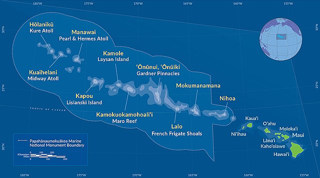
Deutsch: Karte des Papahānaumokuākea Marine National Monument (2016)
English: Map of Papahānaumokuākea Marine National Monument (2016) |
| Data | |
| Sors | http://www.papahanaumokuakea.gov/ |
| Awtur | NOAA |
Liċenzja
This image is in the public domain because it contains materials that originally came from the U.S. National Oceanic and Atmospheric Administration, taken or made as part of an employee's official duties.
|
Kronoloġija tal-fajl
Agħfas fuq il-grupp data/ħin biex tara l-fajl biex tara kif jidher dak il-ħin.
| Data/Ħin | Minjatura | Qisien | Utent | Kumment | |
|---|---|---|---|---|---|
| kurrenti | 09:29, 28 Awwissu 2016 | | 1,200 × 667 (249 KB) | NordNordWest | == {{int:filedesc}} == {{Information |Description={{de|Karte des Papahānaumokuākea Marine National Monument (2016)}} {{en|Map of [[:en:Papahānaumokuākea Marine National Monument|Papahānaumokuāk... |
Użu tal-fajl
Il-Paġna segwenti twassal għal din l-istampa:
L-użu globali tal-fajl
Il-wikis segwenti jużaw dan il-fajl:
- Użu fuq de.wikipedia.org
- Użu fuq en.wikipedia.org
- Użu fuq es.wikipedia.org
- Użu fuq fr.wikipedia.org
- Użu fuq hr.wikipedia.org
- Użu fuq id.wikipedia.org
- Użu fuq it.wikipedia.org
- Użu fuq ja.wikipedia.org
- Użu fuq la.wikipedia.org
- Użu fuq lt.wikipedia.org
- Użu fuq mr.wikipedia.org
- Użu fuq pl.wikipedia.org
- Użu fuq sr.wikipedia.org
- Użu fuq tr.wikipedia.org
- Użu fuq uk.wikipedia.org
- Użu fuq vi.wikipedia.org
- Użu fuq www.wikidata.org
- Użu fuq zh-yue.wikipedia.org
- Użu fuq zh.wikipedia.org