Stampa:Malaspina Glacier, Alaska (boundary).jpg

Fajl oriġinali (6,000 × 6,000 pixel, dimensjoni: 11.5 MB, tip ta' MIME: image/jpeg)

Dan huwa fajl mill-Wikimedia Commons. Il-deskrizzjoni fuq il-paġna ta' diskussjoni oriġinali tidher hawn taħt.
Commons huwa repożitorju ta' fajls multimedjali liċenzjati b'xejn. Int tista' tgħin.

Taqsira

Deskrizzjoni
English: ==Taqsira==
Deskrizzjoni

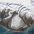
The ice of a piedmont glacier spills from a steep valley onto a relatively flat plain, where it spreads out unconstrained like pancake batter. Elephant Foot Glacier in northeastern Greenland is an excellent example; it is particularly noted for its symmetry. But the largest piedmont glacier in North America (and possibly the world) is Malaspina in southeastern Alaska.

On September 24, 2014, the Operational Land Imager (OLI) on Landsat 8 acquired this image of Malaspina Glacier. The main source of ice comes from Seward Glacier, located at the top-center of this image. The Agassiz and Libbey glaciers are visible on the left side, and the Hayden and Marvine glaciers are on the right.

The brown lines on the ice are moraines—areas where soil, rock, and other debris have been scraped up by the glacier and deposited at its sides. Where two glaciers flow together, the moraines merge to form a medial moraine. Glaciers that flow at a steady speed tend to have moraines that are relatively straight.

But what causes the dizzying pattern of curves, zigzags, and loops of Malaspina’s moraines? Glaciers in this area of Alaska periodically “surge,”meaning they lurch forward quickly for one to several years. As a result of this irregular flow, the moraines at the edges and between glaciers can become folded, compressed, and sheared to form the characteristic loops seen on Malaspina. For instance, a surge in 1986 displaced moraines on the east side of Malaspina by as much as 5 kilometers (3 miles).

NASA Earth Observatory image by Jesse Allen, using Landsat data from the U.S. Geological Survey. Caption by Kathryn Hansen.

Credit: NASA Earth Observatory

NASA image use policy.

NASA Goddard Space Flight Center enables NASA’s mission through four scientific endeavors: Earth Science, Heliophysics, Solar System Exploration, and Astrophysics. Goddard plays a leading role in NASA’s accomplishments by contributing compelling scientific knowledge to advance the Agency’s mission.

Follow us on Twitter

Like us on Facebook

Find us on Instagram
Data Taken on 24 Settembru 2014
Sors Malaspina Glacier, Alaska
Awtur NASA Goddard Space Flight Center from Greenbelt, MD, USA
Data
Sors Opra proprja
Awtur Nwbeeson

Liċenzja

Jiena, id-detentur tal-copyright ta' dan ix-xogħol, niddikjara li se nippubblikah taħt il-liċenzja segwenti:
w:mt:Creative Commons
attribuzzjoni
This file is licensed under the Creative Commons Attribution 4.0 International license.
Inti ħieles:
  • li taqsam – li tikkopja, tiddistribwixxi u tittrażmetti din l-opra
  • li timmodifika – li tadatta l-biċċa xogħol
Taħt il-kundizzjonijiet segwenti:
  • attribuzzjoni – Għandek tattribwixxi x-xogħol bil-mod speċifikat mill-awtur jew minn min ta l-l-iċenzja (imma mhux b'xi mod li jissuġġerixxi ji jappoġjaw lilek jew l-użu tax-xogħol).

Captions

Add a one-line explanation of what this file represents
Shows the boundary of the Malaspina Glacier which is in Alaska.

Items portrayed in this file

depicts Ingliż

copyrighted Ingliż

24 Settembru 2014

Kronoloġija tal-fajl

Agħfas fuq il-grupp data/ħin biex tara l-fajl biex tara kif jidher dak il-ħin.

Data/ĦinMinjaturaQisienUtentKumment
kurrenti21:44, 27 Frar 2024Minjatura tal-verżjoni ta' 21:44, 27 Frar 20246,000 × 6,000 (11.5 MB)NwbeesonUploaded own work with UploadWizard

Il-Paġna segwenti twassal għal din l-istampa:

L-użu globali tal-fajl

Il-wikis segwenti jużaw dan il-fajl:

Metadati