Stampa:MX-DF-clima.png

Daqs tad-dehra proviżorja: 463 × 599 pixels. Riżoluzzjonijiet oħra: 185 × 240 pixels | 371 × 480 pixels | 816 × 1,056 pixels
Fajl oriġinali (816 × 1,056 pixel, dimensjoni: 98 KB, tip ta' MIME: image/png)
| Dan huwa fajl mill-Wikimedia Commons. Il-deskrizzjoni fuq il-paġna ta' diskussjoni oriġinali tidher hawn taħt.
|
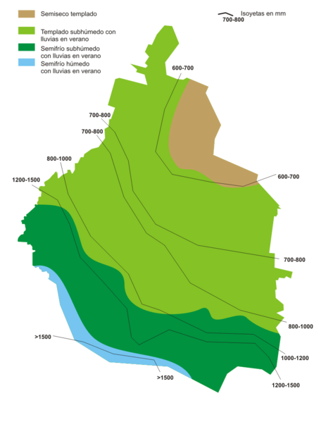
English: Climate pattern map of Mexico City
Español: Mapa climatológico del Distrito Federal de México
| I, the copyright holder of this work, release this work into the public domain. This applies worldwide. In some countries this may not be legally possible; if so: I grant anyone the right to use this work for any purpose, without any conditions, unless such conditions are required by law. |
vghjg
Kronoloġija tal-fajl
Agħfas fuq il-grupp data/ħin biex tara l-fajl biex tara kif jidher dak il-ħin.
| Data/Ħin | Minjatura | Qisien | Utent | Kumment | |
|---|---|---|---|---|---|
| kurrenti | 19:11, 14 Ġunju 2006 | | 816 × 1,056 (98 KB) | Yavidaxiu | Mapa climatológico del Distrito Federal de México Category:Maps of México {{PD-self}} |
Użu tal-fajl
Il-Paġna segwenti twassal għal din l-istampa:
L-użu globali tal-fajl
Il-wikis segwenti jużaw dan il-fajl:
- Użu fuq an.wikipedia.org
- Użu fuq bg.wikipedia.org
- Użu fuq ca.wikipedia.org
- Użu fuq de.wikipedia.org
- Użu fuq en.wikipedia.org
- Użu fuq es.wikipedia.org
- Użu fuq eu.wikipedia.org
- Użu fuq fr.wikipedia.org
- Użu fuq io.wikipedia.org
- Użu fuq it.wikipedia.org
- Użu fuq ka.wikipedia.org
- Użu fuq lad.wikipedia.org
- Użu fuq ms.wikipedia.org
- Użu fuq roa-tara.wikipedia.org
- Użu fuq sr.wikipedia.org
- Użu fuq ta.wikipedia.org
- Użu fuq tr.wikipedia.org