Stampa:Joppen1907India1805a.jpg
Fajl oriġinali (843 × 1,200 pixel, dimensjoni: 230 KB, tip ta' MIME: image/jpeg)
| Dan huwa fajl mill-Wikimedia Commons. Il-deskrizzjoni fuq il-paġna ta' diskussjoni oriġinali tidher hawn taħt.
|
Taqsira
| Deskrizzjoni |
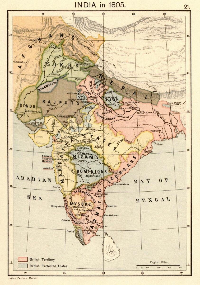
English: Map of India 1805 from: Joppen, Charles [SJ.] (1907) A Historical Atlas of India for the use of High-Schools, Colleges, and Private Students, London, New York, Bombay, and Calcutta: Longman Green and Co. Pp. 16, 26 maps. Scanned from personal copy, reduced, uploaded by Fowler&fowler«Talk» 23:51, 24 February 2009 (UTC) |
| Data | |
| Sors | Joppen, Charles [SJ.] (1907) A Historical Atlas of India for the use of High-Schools, Colleges, and Private Students, London, New York, Bombay, and Calcutta: Longman Green and Co. Pp. 16, 26 maps |
| Awtur | Justus Perthes, Gotha./Charles Joppen |
| Verżjonijiet oħra |
 |
Liċenzja
This image is in the public domain because it is a mere mechanical scan or photocopy of a public domain original, or – from the available evidence – is so similar to such a scan or photocopy that no copyright protection can be expected to arise. The original itself is in the public domain for the following reason:
This tag is designed for use where there may be a need to assert that any enhancements (eg brightness, contrast, colour-matching, sharpening) are in themselves insufficiently creative to generate a new copyright. It can be used where it is unknown whether any enhancements have been made, as well as when the enhancements are clear but insufficient. For known raw unenhanced scans you can use an appropriate {{PD-old}} tag instead. For usage, see Commons:When to use the PD-scan tag.  | ||||
Kronoloġija tal-fajl
Agħfas fuq il-grupp data/ħin biex tara l-fajl biex tara kif jidher dak il-ħin.
| Data/Ħin | Minjatura | Qisien | Utent | Kumment | |
|---|---|---|---|---|---|
| kurrenti | 16:16, 18 April 2010 | | 843 × 1,200 (230 KB) | Beao | Removed watermark. |
| 23:51, 24 Frar 2009 |  | 843 × 1,200 (209 KB) | Fowler&fowler | {{Information |Description=Map of India 1805 from: {{Harvard reference|last=Joppen|first=Charles [SJ.]|year=1907|title=A Historical Atlas of India for the use of High-Schools, Colleges, and Private Students|publisher=London, New York, Bombay, and Calcutta |
Użu tal-fajl
Il-Paġna segwenti twassal għal din l-istampa:
L-użu globali tal-fajl
Il-wikis segwenti jużaw dan il-fajl:
- Użu fuq azb.wikipedia.org
- Użu fuq es.wikipedia.org
- Użu fuq hi.wikipedia.org
- Użu fuq it.wikipedia.org
- Użu fuq ne.wikipedia.org
- Użu fuq pt.wikipedia.org
- Użu fuq vi.wikipedia.org