Stampa:Ireland (MODIS).jpg
Daqs tad-dehra proviżorja: 436 × 600 pixels. Riżoluzzjonijiet oħra: 174 × 240 pixels | 349 × 480 pixels | 558 × 768 pixels | 745 × 1,024 pixels | 1,600 × 2,200 pixels
Fajl oriġinali (1,600 × 2,200 pixel, dimensjoni: 2.69 MB, tip ta' MIME: image/jpeg)
| Dan huwa fajl mill-Wikimedia Commons. Il-deskrizzjoni fuq il-paġna ta' diskussjoni oriġinali tidher hawn taħt.
|
Taqsira
| Deskrizzjoni |
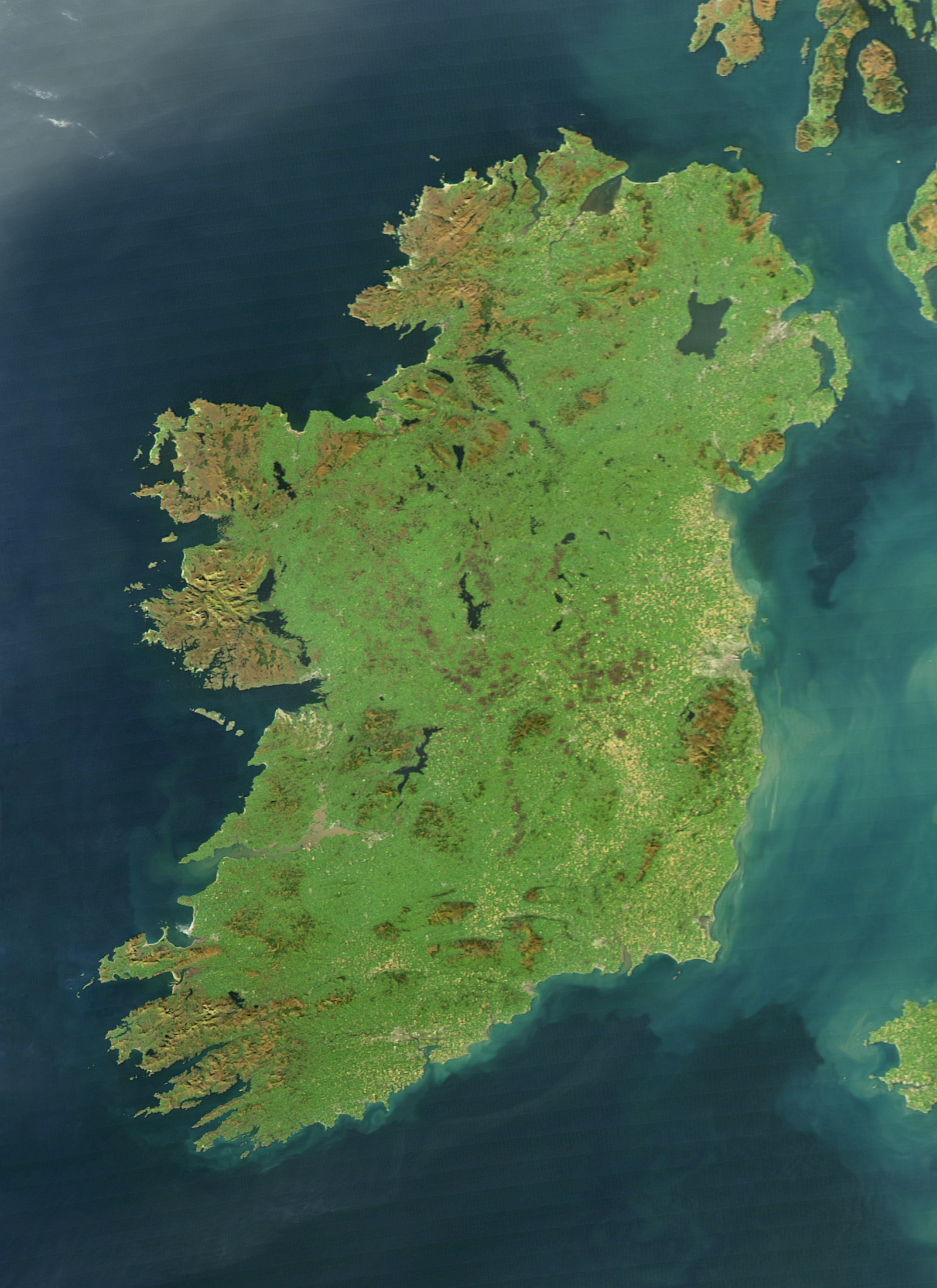
English: It is easy to see from this true-colour image why Ireland is called the Emerald Isle. Intense green vegetation, primarily grassland, covers most of the country except for the exposed rock on mountaintops. Ireland owes its greenness to moderate temperatures and moist air. The Atlantic Ocean, particularly the warm currents in the North Atlantic Drift, gives the country a more temperate climate than most others at the same latitude. |
| Data | |
| Sors | NASA Earth Observatory |
| Awtur | Jeff Schmaltz |
| Verżjonijiet oħra |
|
.jpg)
The cloud-free view shown here is extremely rare. The Moderate Resolution Imaging Spectroradiometer (MODIS) on NASA’s Aqua satellite captured the image on October 11, 2010, a time of year when Irish weather alternates between rainstorms from the west and cool, dry weather brought by high pressure systems known as anticyclones.
Liċenzja
| This file is in the public domain in the United States because it was solely created by NASA. NASA copyright policy states that "NASA material is not protected by copyright unless noted". (See Template:PD-USGov, NASA copyright policy page or JPL Image Use Policy.) | ||
 |
Warnings:
|
Kronoloġija tal-fajl
Agħfas fuq il-grupp data/ħin biex tara l-fajl biex tara kif jidher dak il-ħin.
| Data/Ħin | Minjatura | Qisien | Utent | Kumment | |
|---|---|---|---|---|---|
| kurrenti | 12:14, 4 Awwissu 2017 | | 1,600 × 2,200 (2.69 MB) | Blight55 | quality degraded from original, taken from original |
| 10:04, 21 April 2017 |  | 1,600 × 2,200 (1.16 MB) | Blight55 | No borders in space, removed clouds | |
| 20:18, 25 Diċembru 2011 |  | 1,600 × 2,200 (532 KB) | Tóraí | Less sever colour adjustments from original. | |
| 13:41, 13 Diċembru 2011 |  | 1,512 × 1,928 (800 KB) | Soerfm | Brightness, crop | |
| 10:22, 17 Marzu 2011 |  | 1,600 × 2,200 (409 KB) | Originalwana | {{Information |Description ={{en|1=It is easy to see from this true-colour image why Ireland is called the Emerald Isle. Intense green vegetation, primarily grassland, covers most of the country except for the exposed rock on mountaintops. Ireland |
Użu tal-fajl
Il-Paġna segwenti twassal għal din l-istampa:
L-użu globali tal-fajl
Il-wikis segwenti jużaw dan il-fajl:
- Użu fuq af.wikipedia.org
- Użu fuq ar.wikipedia.org
- Użu fuq arz.wikipedia.org
- Użu fuq ast.wikipedia.org
- Użu fuq az.wikipedia.org
- Użu fuq be-tarask.wikipedia.org
- Użu fuq br.wikipedia.org
- Użu fuq ca.wikipedia.org
- Użu fuq ceb.wikipedia.org
- Użu fuq cy.wikipedia.org
- Użu fuq da.wikipedia.org
- Użu fuq de.wikipedia.org
- Użu fuq el.wikipedia.org
- Użu fuq en.wikipedia.org
- Ireland
- Geography of Ireland
- Gaelic Athletic Association
- Irish Rugby Football Union
- Swim Ireland
- Sport in Ireland
- United Ireland
- Rugby League Ireland
- Irish Real Tennis Association
- Irish Sailing Association
- Hurlingham Polo Association
- List of fractals by Hausdorff dimension
- Cricket Ireland
- Australian Rules Football League of Ireland
- Baseball in Ireland
- Irish Ice Hockey Association
- Baseball Ireland
- Fencing Ireland
- Olympic Federation of Ireland
- Ladies' Gaelic Football Association
- Softball in Ireland
- Pitch and Putt Union of Ireland
- Cycling Ireland
- Horse Sport Ireland
- Basketball Ireland
- Tennis Ireland
- Boxing Union of Ireland
- Parachute Association of Ireland
- Football Association of Ireland
- Hockey Ireland
Ara l-użu globali ta' dan il-fajl.
.jpg)
.jpg)