Stampa:Illinois 1718.jpg

Daqs tad-dehra proviżorja: 479 × 599 pixels. Riżoluzzjonijiet oħra: 192 × 240 pixels | 589 × 737 pixels
Fajl oriġinali (589 × 737 pixel, dimensjoni: 232 KB, tip ta' MIME: image/jpeg)
| Dan huwa fajl mill-Wikimedia Commons. Il-deskrizzjoni fuq il-paġna ta' diskussjoni oriġinali tidher hawn taħt.
|
Taqsira
| Deskrizzjoni |
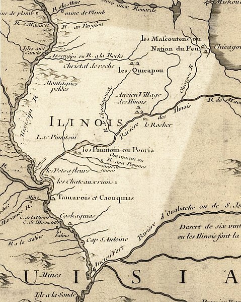
English: Illinois in 1718, approximate modern state area highlighted, from Carte de la Louisiane et du cours du Mississipi by Guillaume de L'Isle. This map shows Chicago as being the strategic point of connection between the Great Lakes and the Mississippi River Basin. |
|||||||||||||||||||||||
| Data | (rev. 2009) | |||||||||||||||||||||||
| Sors |
|
|||||||||||||||||||||||
| Awtur |
|
|||||||||||||||||||||||
| Permess (Użu mill-ġdid tal-fajl) |
US Govt Public Domain, also author +100 years | |||||||||||||||||||||||

Liċenzja
|
This work is in the public domain in its country of origin and other countries and areas where the copyright term is the author's life plus 100 years or fewer. | |
| This file has been identified as being free of known restrictions under copyright law, including all related and neighboring rights. | |
Original upload log
The original description page was here. All following user names refer to en.wikipedia.
- 2009-07-25 15:17 Billwhittaker 589×737× (237103 bytes) {{Information |Description = Illinois in 1718, approximate modern state area highlighted, from ''Carte de la Louisiane et du cours du Mississipi'' by [[Guillaume de L'Isle]]. |Source = Library of Congress Public Domain Site: http://hdl.loc.go
Kronoloġija tal-fajl
Agħfas fuq il-grupp data/ħin biex tara l-fajl biex tara kif jidher dak il-ħin.
| Data/Ħin | Minjatura | Qisien | Utent | Kumment | |
|---|---|---|---|---|---|
| kurrenti | 19:42, 21 Settembru 2009 | | 589 × 737 (232 KB) | Jeangagnon | {{Information |Description={{en|Illinois in 1718, approximate modern state area highlighted, from ''Carte de la Louisiane et du cours du Mississipi'' by en:Guillaume de L'Isle.}} |Source=Transferred from [http://en.wikipedia.org en.wikipedia]<br/> ( |
Użu tal-fajl
Il-Paġna segwenti twassal għal din l-istampa:
L-użu globali tal-fajl
Il-wikis segwenti jużaw dan il-fajl:
- Użu fuq ar.wikipedia.org
- Użu fuq arz.wikipedia.org
- Użu fuq bg.wikipedia.org
- Użu fuq en.wikipedia.org
- Użu fuq en.wikibooks.org
- Użu fuq es.wikipedia.org
- Użu fuq he.wikipedia.org
- Użu fuq ja.wikipedia.org
- Użu fuq pt.wikipedia.org
- Użu fuq ru.wikipedia.org
- Użu fuq uk.wikipedia.org