Stampa:Gambia Map.png

Daqs tad-dehra proviżorja: 500 × 599 pixels. Riżoluzzjonijiet oħra: 200 × 240 pixels | 400 × 480 pixels | 1,006 × 1,206 pixels
Fajl oriġinali (1,006 × 1,206 pixel, dimensjoni: 228 KB, tip ta' MIME: image/png)
| Dan huwa fajl mill-Wikimedia Commons. Il-deskrizzjoni fuq il-paġna ta' diskussjoni oriġinali tidher hawn taħt.
|
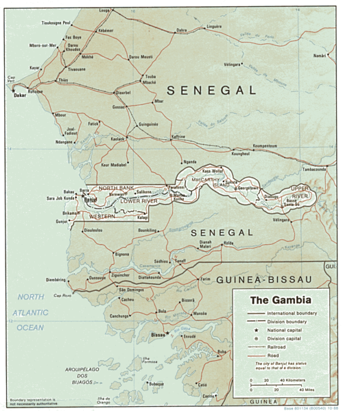
| Deskrizzjoni | Shaded relief map of The Gambia. | |||
| Data | ||||
| Sors | [1] from the Perry-Castañeda Library Map Collection. | |||
| Awtur | CIA | |||
| Permess (Użu mill-ġdid tal-fajl) |
|

![[1]](http://www.lib.utexas.edu/maps/africa/gambia.gif)
Kronoloġija tal-fajl
Agħfas fuq il-grupp data/ħin biex tara l-fajl biex tara kif jidher dak il-ħin.
| Data/Ħin | Minjatura | Qisien | Utent | Kumment | |
|---|---|---|---|---|---|
| kurrenti | 13:03, 22 Frar 2006 | | 1,006 × 1,206 (228 KB) | Lupo | Shaded relief map of The Gambia. Source: [http://www.lib.utexas.edu/maps/africa/gambia.gif] from the [http://www.lib.utexas.edu/maps/gambia.html Perry-Castañeda Library Map Collection]. {{PD-USGov-CIA}} Category:Maps of the Gambia |
Użu tal-fajl
Il-Paġna segwenti twassal għal din l-istampa:
L-użu globali tal-fajl
Il-wikis segwenti jużaw dan il-fajl:
- Użu fuq ast.wikipedia.org
- Użu fuq ca.wikipedia.org
- Użu fuq en.wikipedia.org
- Użu fuq es.wikipedia.org
- Użu fuq fr.wikipedia.org
- Użu fuq hr.wiktionary.org
- Użu fuq tl.wikipedia.org
- Użu fuq uk.wikipedia.org
- Użu fuq vi.wikipedia.org