Stampa:Gabon Topography.png

Daqs tad-dehra proviżorja: 617 × 599 pixels. Riżoluzzjonijiet oħra: 247 × 240 pixels | 494 × 480 pixels | 791 × 768 pixels | 1,054 × 1,024 pixels | 1,297 × 1,260 pixels
Fajl oriġinali (1,297 × 1,260 pixel, dimensjoni: 1.62 MB, tip ta' MIME: image/png)
| Dan huwa fajl mill-Wikimedia Commons. Il-deskrizzjoni fuq il-paġna ta' diskussjoni oriġinali tidher hawn taħt.
|
Taqsira
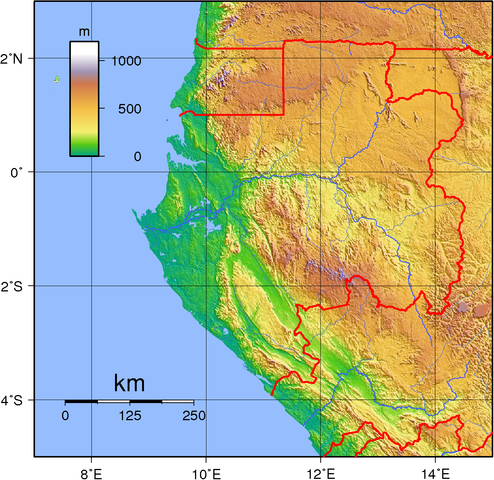
| Deskrizzjoni | Topographic map of Gabon. Created with GMT from SRTM data. |
| Data | |
| Sors | Opra proprja |
| Awtur | Sadalmelik |
Liċenzja
| This work has been released into the public domain by its author, I, Sadalmelik. This applies worldwide. In some countries this may not be legally possible; if so: I, Sadalmelik grants anyone the right to use this work for any purpose, without any conditions, unless such conditions are required by law. |
Kronoloġija tal-fajl
Agħfas fuq il-grupp data/ħin biex tara l-fajl biex tara kif jidher dak il-ħin.
| Data/Ħin | Minjatura | Qisien | Utent | Kumment | |
|---|---|---|---|---|---|
| kurrenti | 19:51, 29 Ġunju 2007 | | 1,297 × 1,260 (1.62 MB) | Sadalmelik | {{Information |Description=Topographic map of Gabon. Created with GMT from SRTM data. |Source=self-made |Date=June 29, 2007 |Author= Sadalmelik }} Category:Maps of Gabon Category:Topographic maps of Gabon |
Użu tal-fajl
Il-Paġna segwenti twassal għal din l-istampa:
L-użu globali tal-fajl
Il-wikis segwenti jużaw dan il-fajl:
- Użu fuq ar.wikipedia.org
- Użu fuq bg.wikipedia.org
- Użu fuq en.wikipedia.org
- Użu fuq es.wikipedia.org
- Użu fuq et.wikipedia.org
- Użu fuq fr.wikipedia.org
- Użu fuq gl.wikipedia.org
- Użu fuq ha.wikipedia.org
- Użu fuq hr.wikipedia.org
- Użu fuq hu.wikipedia.org
- Użu fuq ig.wikipedia.org
- Użu fuq ja.wikipedia.org
- Użu fuq ka.wikipedia.org
- Użu fuq lt.wikipedia.org
- Użu fuq mg.wikipedia.org
- Użu fuq nl.wikipedia.org
- Użu fuq pt.wikipedia.org
- Użu fuq tum.wikipedia.org
- Użu fuq uk.wikipedia.org
- Użu fuq vep.wikipedia.org