Stampa:French Empire on World 1812.png
Daqs tad-dehra proviżorja: 800 × 370 pixels. Riżoluzzjonijiet oħra: 320 × 148 pixels | 640 × 296 pixels | 1,357 × 628 pixels
Fajl oriġinali (1,357 × 628 pixel, dimensjoni: 15 KB, tip ta' MIME: image/png)
| Dan huwa fajl mill-Wikimedia Commons. Il-deskrizzjoni fuq il-paġna ta' diskussjoni oriġinali tidher hawn taħt.
|
Taqsira
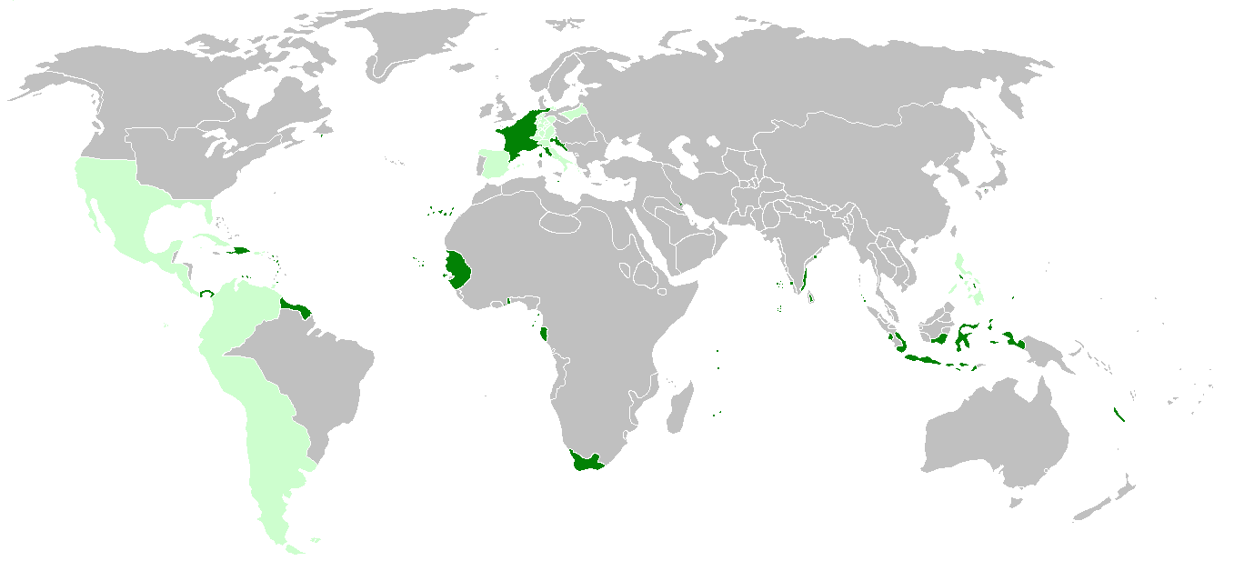
| Deskrizzjoni | First French Empire before the french invasion of Russia on World 1812, with annexed or occupied colonies, satellite states, allied states and dependent colonies. | ||
| Data | |||
| Sors | http://de.wikipedia.org/wiki/Erstes_Kaiserreich, napoleonská Francie a Evropa 1812 | ||
| Awtur | Hruska | ||
| Verżjonijiet oħra |
|

Liċenzja
Jiena, id-detentur tal-copyright ta' dan ix-xogħol, niddikjara li se nippubblikah taħt il-liċenzja segwenti:
Dan il-fajl huwa liċenzjat taħt it-termini tal-liċenzja Creative Commons Attribuzzjoni-Aqsam bl-istess mod 3.0 Unported
- Inti ħieles:
- li taqsam – li tikkopja, tiddistribwixxi u tittrażmetti din l-opra
- li timmodifika – li tadatta l-biċċa xogħol
- Taħt il-kundizzjonijiet segwenti:
- attribuzzjoni – Għandek tattribwixxi x-xogħol bil-mod speċifikat mill-awtur jew minn min ta l-l-iċenzja (imma mhux b'xi mod li jissuġġerixxi ji jappoġjaw lilek jew l-użu tax-xogħol).
- Ixxerja bl-istess mod – Jekk tbiddel, tittrasforma jew tibni fuq dan il-materjal, inti għandek bżonn taqsam il-kontribuzzjonijiet tiegħek taħt l-istess liċenzja jew waħda li taqbel ma' dik oriġinali.
Kronoloġija tal-fajl
Agħfas fuq il-grupp data/ħin biex tara l-fajl biex tara kif jidher dak il-ħin.
| Data/Ħin | Minjatura | Qisien | Utent | Kumment | |
|---|---|---|---|---|---|
| kurrenti | 23:51, 17 Marzu 2022 | | 1,357 × 628 (15 KB) | M.Bitton | per [https://commons.wikimedia.org/w/index.php?title=Commons:Graphic_Lab/Map_workshop&oldid=640501111#Wrong_borders] |
| 21:08, 25 April 2021 |  | 1,357 × 628 (33 KB) | M.Bitton | Reverted to version as of 15:19, 6 December 2014 (UTC): If you don't want to be reported to the admins, I suggest you stop edit warring and read COM:OVERWRITE | |
| 14:58, 25 April 2021 |  | 1,357 × 628 (30 KB) | محمد٢ | Morocco wasn't a Spanish satellite state | |
| 22:04, 15 April 2021 |  | 1,357 × 628 (33 KB) | M.Bitton | Reverted to version as of 15:19, 6 December 2014 (UTC): per COM:OVERWRITE | |
| 21:37, 14 April 2021 |  | 1,357 × 628 (30 KB) | محمد٢ | Reverted to version as of 20:17, 14 April 2021 (UTC) | |
| 20:23, 14 April 2021 |  | 1,357 × 628 (30 KB) | محمد٢ | Reverted to version as of 18:02, 14 April 2021 (UTC) | |
| 20:17, 14 April 2021 |  | 1,357 × 628 (30 KB) | محمد٢ | border | |
| 18:02, 14 April 2021 |  | 1,357 × 628 (30 KB) | محمد٢ | border | |
| 15:19, 6 Diċembru 2014 |  | 1,357 × 628 (33 KB) | Hruska~commonswiki | broder | |
| 09:58, 6 Diċembru 2014 |  | 1,357 × 628 (33 KB) | Hruska~commonswiki | island |
Użu tal-fajl
Il-Paġna segwenti twassal għal din l-istampa:
L-użu globali tal-fajl
Il-wikis segwenti jużaw dan il-fajl:
- Użu fuq ar.wikipedia.org
- Użu fuq ast.wikipedia.org
- Użu fuq be.wikipedia.org
- Użu fuq br.wikipedia.org
- Użu fuq de.wikipedia.org
- Użu fuq el.wikipedia.org
- Użu fuq en.wikipedia.org
- Użu fuq es.wikipedia.org
- Użu fuq eu.wikipedia.org
- Użu fuq fa.wikipedia.org
- Użu fuq fr.wikipedia.org
- Użu fuq hr.wikipedia.org
- Użu fuq id.wikipedia.org
- Użu fuq it.wikipedia.org
- Użu fuq ja.wikipedia.org
- Użu fuq kk.wikipedia.org
- Użu fuq lt.wikipedia.org
- Użu fuq mn.wikipedia.org
- Użu fuq ms.wikipedia.org
- Użu fuq rm.wikipedia.org
- Użu fuq th.wikipedia.org
- Użu fuq uk.wikipedia.org
- Użu fuq vi.wikipedia.org
- Użu fuq www.wikidata.org
- Użu fuq zh.wikipedia.org