Stampa:EthniesSénégal.jpg

Daqs tad-dehra proviżorja: 800 × 470 pixels. Riżoluzzjonijiet oħra: 320 × 188 pixels | 640 × 376 pixels | 1,024 × 602 pixels | 1,280 × 752 pixels | 2,420 × 1,422 pixels
Fajl oriġinali (2,420 × 1,422 pixel, dimensjoni: 438 KB, tip ta' MIME: image/jpeg)
| Dan huwa fajl mill-Wikimedia Commons. Il-deskrizzjoni fuq il-paġna ta' diskussjoni oriġinali tidher hawn taħt.
|
Taqsira
| Deskrizzjoni |
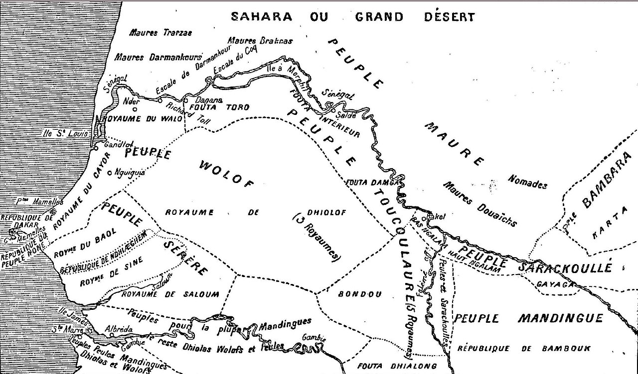
Français : Carte des peuplades du Sénégal de l'abbé David Boilat (1853). |
||
| Data | |||
| Sors |
|
||
| Awtur | Abbé Boilat |
Liċenzja
|
This work is in the public domain in its country of origin and other countries and areas where the copyright term is the author's life plus 100 years or fewer. This work is in the public domain in the United States because it was published (or registered with the U.S. Copyright Office) before January 1, 1929. | |
| This file has been identified as being free of known restrictions under copyright law, including all related and neighboring rights. | |
Kronoloġija tal-fajl
Agħfas fuq il-grupp data/ħin biex tara l-fajl biex tara kif jidher dak il-ħin.
| Data/Ħin | Minjatura | Qisien | Utent | Kumment | |
|---|---|---|---|---|---|
| kurrenti | 19:21, 22 April 2007 | | 2,420 × 1,422 (438 KB) | Ji-Elle | {{Information |Description=Carte des peuplades du Sénégal de l'abbé Boilat (1853) |Source=G. G. Beslier, ''Le Sénégal'' (1935), p. 30 |Date=1853 |Author=Abbé Boilat }} Category:Old maps of Senegal |
Użu tal-fajl
Il-Paġna segwenti twassal għal din l-istampa:
L-użu globali tal-fajl
Il-wikis segwenti jużaw dan il-fajl:
- Użu fuq af.wikipedia.org
- Użu fuq ar.wikipedia.org
- Użu fuq ast.wikipedia.org
- Użu fuq bn.wikipedia.org
- Użu fuq ca.wikipedia.org
- Użu fuq en.wikipedia.org
- Użu fuq eo.wikipedia.org
- Użu fuq es.wikipedia.org
- Użu fuq eu.wikipedia.org
- Użu fuq fi.wikipedia.org
- Użu fuq fr.wikipedia.org
- Użu fuq ha.wikipedia.org
Ara l-użu globali ta' dan il-fajl.