Stampa:Djerba Island.jpeg

Daqs tad-dehra proviżorja: 600 × 600 pixels. Riżoluzzjonijiet oħra: 240 × 240 pixels | 480 × 480 pixels | 768 × 768 pixels | 1,024 × 1,024 pixels | 2,333 × 2,333 pixels
Fajl oriġinali (2,333 × 2,333 pixel, dimensjoni: 3.86 MB, tip ta' MIME: image/jpeg)
| Dan huwa fajl mill-Wikimedia Commons. Il-deskrizzjoni fuq il-paġna ta' diskussjoni oriġinali tidher hawn taħt.
|
Taqsira
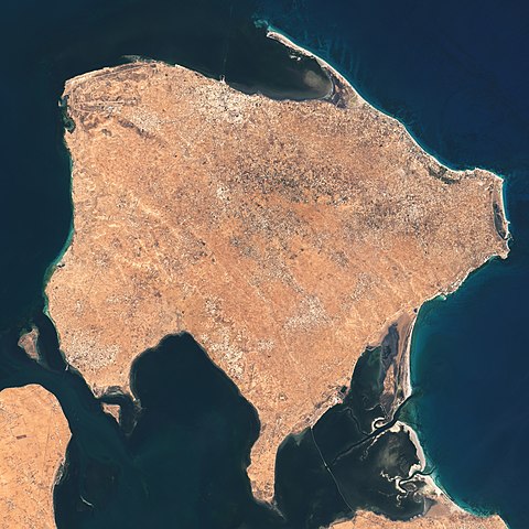
| Deskrizzjoni | The Operational Land Imager (OLI) on Landsat 8 acquired these natural-color images of Ajim on May 4, 2020. |
| Data | |
| Sors | https://earthobservatory.nasa.gov/images/146772/a-falcon-over-ajim |
| Awtur | NASA Earth Observatory images by Lauren Dauphin, using Landsat data from the U.S. Geological Survey. Story by Adam Voiland. |
Liċenzja
| This file is in the public domain in the United States because it was solely created by NASA. NASA copyright policy states that "NASA material is not protected by copyright unless noted". (See Template:PD-USGov, NASA copyright policy page or JPL Image Use Policy.) | ||
 |
Warnings:
|
Kronoloġija tal-fajl
Agħfas fuq il-grupp data/ħin biex tara l-fajl biex tara kif jidher dak il-ħin.
| Data/Ħin | Minjatura | Qisien | Utent | Kumment | |
|---|---|---|---|---|---|
| kurrenti | 02:39, 26 Mejju 2021 | | 2,333 × 2,333 (3.86 MB) | StellarHalo | {{Information |Description=The Operational Land Imager (OLI) on Landsat 8 acquired these natural-color images of Ajim on May 4, 2020. |Source=https://earthobservatory.nasa.gov/images/146772/a-falcon-over-ajim |Date=4 May 2020 |Author=NASA Earth Observatory images by Lauren Dauphin, using Landsat data from the U.S. Geological Survey. Story by Adam Voiland. |Permission= |other_versions= }} Category:Satellite pictures by Landsat 8 Category:Satellite pictures of Tunisia Category:Djerba |
Użu tal-fajl
Il-Paġna segwenti twassal għal din l-istampa:
L-użu globali tal-fajl
Il-wikis segwenti jużaw dan il-fajl:
- Użu fuq en.wikipedia.org
- Użu fuq fr.wikipedia.org
- Użu fuq pl.wikipedia.org