Stampa:Departements of French Empire South 1811-fr.svg

Size of this PNG preview of this SVG file: 697 × 600 pixels. Riżoluzzjonijiet oħra: 279 × 240 pixels | 558 × 480 pixels | 892 × 768 pixels | 1,190 × 1,024 pixels | 2,379 × 2,048 pixels | 1,020 × 878 pixels
Fajl oriġinali (Fajl fil-format SVG, dimensjoni nominali 1,020 × 878 pixel, dimensjoni tal-fajl: 235 KB)
| Dan huwa fajl mill-Wikimedia Commons. Il-deskrizzjoni fuq il-paġna ta' diskussjoni oriġinali tidher hawn taħt.
|
Taqsira
| Deskrizzjoni |
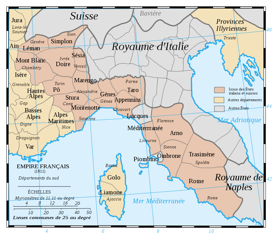
Français : Les départements du Sud du 1er Empire français (1811).
Attention: Cette carte est une carte historique. La qualité de sa précision ne permet pas une utilisation dans un contexte moderne.
English: French Departements of the South of the first Empire (1811)
Be careful: The map is an historical map. The precision is not sufficient for a modern use. |
| Data | |
| Sors | Tiré d'une carte établie en 1811 par Messieurs Drioux et Leroy. |
| Awtur | Ewan ar Born |
| Verżjonijiet oħra |
|
| SVG genesis |


|
This SVG file contains embedded text that can be translated into your language, using any capable SVG editor, text editor or the SVG Translate tool. For more information see: About translating SVG files. |
Liċenzja
| I, the copyright holder of this work, release this work into the public domain. This applies worldwide. In some countries this may not be legally possible; if so: I grant anyone the right to use this work for any purpose, without any conditions, unless such conditions are required by law. |
Kronoloġija tal-fajl
Agħfas fuq il-grupp data/ħin biex tara l-fajl biex tara kif jidher dak il-ħin.
| Data/Ħin | Minjatura | Qisien | Utent | Kumment | |
|---|---|---|---|---|---|
| kurrenti | 09:52, 28 Lulju 2019 | | 1,020 × 878 (235 KB) | Augusta 89 | Demande à l'atelier cartographique (fr) : meilleur contraste entre les couleurs et correction de la couleur pour la Corse. |
| 08:47, 30 Awwissu 2017 |  | 1,020 × 878 (236 KB) | Ras67 | cropped | |
| 12:59, 29 Settembru 2008 |  | 1,020 × 880 (287 KB) | Ewan ar Born | == Description == {{Information |Description={{fr|1=Les départements du Sud du 1er Empire français (1811). Attention: Cette carte est une carte historique. La qualité de sa précision ne permet pas une utilisation dans un contexte moderne.}} {{en|1=Fre |
Użu tal-fajl
Il-Paġna segwenti twassal għal din l-istampa:
L-użu globali tal-fajl
Il-wikis segwenti jużaw dan il-fajl:
- Użu fuq ar.wikipedia.org
- Użu fuq bg.wikipedia.org
- Użu fuq br.wikipedia.org
- Użu fuq ca.wikipedia.org
- Użu fuq de.wikipedia.org
- Użu fuq en.wikipedia.org
- Mont-Blanc (department)
- Apennins
- Arno (department)
- Doire
- Gênes
- Montenotte (department)
- Marengo (department)
- Stura
- Pô (department)
- Méditerranée
- Rome (department)
- Simplon (department)
- Taro (department)
- Trasimène
- Liamone
- Sésia
- Ombrone (department)
- Golo (department)
- Tanaro (department)
- Antoine-Marie Roederer
- History of Valais
- Użu fuq eo.wikipedia.org
- Użu fuq fr.wikipedia.org
Ara l-użu globali ta' dan il-fajl.