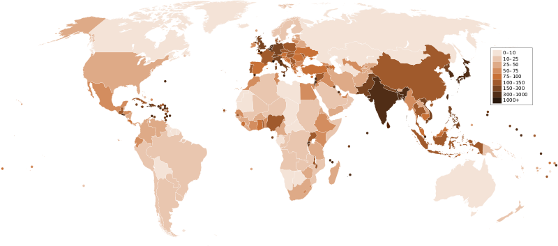
Stampa:Countries by population density.svg

Size of this PNG preview of this SVG file: 800 × 353 pixels. Riżoluzzjonijiet oħra: 320 × 141 pixels | 640 × 282 pixels | 1,024 × 452 pixels | 1,280 × 565 pixels | 2,560 × 1,129 pixels | 6,000 × 2,647 pixels
Fajl oriġinali (Fajl fil-format SVG, dimensjoni nominali 6,000 × 2,647 pixel, dimensjoni tal-fajl: 1.62 MB)
Kronoloġija tal-fajl
Agħfas fuq il-grupp data/ħin biex tara l-fajl biex tara kif jidher dak il-ħin.
| Data/Ħin | Minjatura | Qisien | Utent | Kumment | |
|---|---|---|---|---|---|
| kurrenti | 23:33, 21 Diċembru 2011 |  | 6,000 × 2,647 (1.62 MB) | Quibik | added transparency |
| 13:43, 20 Frar 2011 |  | 6,000 × 2,647 (1.62 MB) | Erik del Toro Streb | typographically corrected | |
| 02:22, 7 Jannar 2008 |  | 6,000 × 2,647 (1.62 MB) | Briefplan~commonswiki | {{Information |Description=A map of the world, with colours to highlight the population density of each country or territory. Numbers on the legend are in people per km<sup>2</sup>, and all countries smaller than 20,000 km<sup>2</sup> are represented by a |
Użu tal-fajl
Il-Paġna segwenti twassal għal din l-istampa:
L-użu globali tal-fajl
Il-wikis segwenti jużaw dan il-fajl:
- Użu fuq af.wikipedia.org
- Użu fuq ar.wikipedia.org
- Użu fuq arz.wikipedia.org
- Użu fuq ast.wikipedia.org
- Użu fuq av.wikipedia.org
- Użu fuq awa.wikipedia.org
- Użu fuq azb.wikipedia.org
- Użu fuq az.wikipedia.org
- Użu fuq ba.wikipedia.org
- Użu fuq be.wikipedia.org
- Użu fuq bg.wikipedia.org
- Użu fuq bs.wikipedia.org
- Użu fuq ca.wikipedia.org
- Użu fuq ckb.wikipedia.org
- Użu fuq cs.wikipedia.org
- Użu fuq cy.wikipedia.org
- Użu fuq de.wikipedia.org
- Użu fuq de.wikiversity.org
- Użu fuq diq.wikipedia.org
- Użu fuq dsb.wikipedia.org
- Użu fuq en.wikipedia.org
- Użu fuq eo.wikipedia.org
- Użu fuq es.wikipedia.org
- Użu fuq eu.wikipedia.org
- Użu fuq fi.wikipedia.org
- Użu fuq fr.wikipedia.org
Ara l-użu globali ta' dan il-fajl.