Stampa:Cook Islands (New Zealand) map.png
Mhux disponibli verżjonijiet b'risoluzzjoni akbar.
Cook_Islands_(New_Zealand)_map.png (324 × 348 pixel, dimensjoni: 15 KB, tip ta' MIME: image/png)
| Dan huwa fajl mill-Wikimedia Commons. Il-deskrizzjoni fuq il-paġna ta' diskussjoni oriġinali tidher hawn taħt.
|
_map.png)
Taqsira
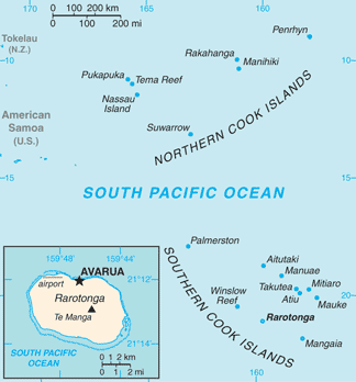
| Deskrizzjoni |
English: Map of Cook Islands (New Zealand)
Italiano: Mappa delle Isole Cook (Nuova Zelanda) |
|||
| Data | ||||
| Sors | https://www.cia.gov/library/publications/the-world-factbook/geos/cw.html | |||
| Awtur | Directorate of Intelligence, CIA | |||
| Permess (Użu mill-ġdid tal-fajl) |
|
Liċenzja
This image is in the public domain because it contains materials that originally came from the United States Central Intelligence Agency's World Factbook.
|
 |
Original upload log
| Data/Ħin | Qisien | Utent | Kumment |
|---|---|---|---|
| 16 Marzu 2013, 18:45:06 | 328 × 353 (19796 bytes) | Edoardo Cavaleri (diskussjoni · kontributi) | {{Information |Description ={{en|1=Map of Cook Islands (New Zealand)}} {{it|1=Mappa delle Isole Cook (Nuova Zelanda)}} |Source =https://www.cia.gov/library/publications/the-world-factbook/geos/cw.html |Author =Directorate of Intellig... |
Kronoloġija tal-fajl
Agħfas fuq il-grupp data/ħin biex tara l-fajl biex tara kif jidher dak il-ħin.
| Data/Ħin | Minjatura | Qisien | Utent | Kumment | |
|---|---|---|---|---|---|
| kurrenti | 05:16, 13 Frar 2022 | | 324 × 348 (15 KB) | Lojwe | Cropped 1 % horizontally, 1 % vertically using CropTool with precise mode. |
| 11:38, 25 Novembru 2014 |  | 328 × 353 (19 KB) | GifTagger | Bot: Converting file to superior PNG file. (Source: Cook_Islands_(New_Zealand)_map.gif). This GIF was problematic due to non-greyscale color table. |
_map.gif)
Użu tal-fajl
Il-Paġna segwenti twassal għal din l-istampa:
L-użu globali tal-fajl
Il-wikis segwenti jużaw dan il-fajl:
- Użu fuq ar.wikipedia.org
- Użu fuq ast.wikipedia.org
- Użu fuq ca.wikipedia.org
- Użu fuq co.wikipedia.org
- Użu fuq de.wikipedia.org
- Użu fuq el.wikipedia.org
- Użu fuq en.wikipedia.org
- Użu fuq es.wikipedia.org
- Użu fuq fr.wikipedia.org
- Użu fuq gl.wikipedia.org
- Użu fuq hif.wikipedia.org
- Użu fuq incubator.wikimedia.org
- Użu fuq io.wikipedia.org
- Użu fuq it.wikipedia.org
- Użu fuq ja.wikipedia.org
- Użu fuq pt.wikipedia.org
- Użu fuq ro.wikipedia.org
- Użu fuq ru.wikipedia.org
- Użu fuq sr.wikipedia.org
- Użu fuq test.wikidata.org
- Użu fuq tg.wikipedia.org
- Użu fuq th.wikipedia.org
- Użu fuq tl.wikipedia.org
- Użu fuq uk.wikipedia.org
- Użu fuq www.wikidata.org
- Użu fuq zh.wikipedia.org
_map.png)