Stampa:Congo regions named.png
Mhux disponibli verżjonijiet b'risoluzzjoni akbar.
Congo_regions_named.png (300 × 337 pixel, dimensjoni: 14 KB, tip ta' MIME: image/png)
| Dan huwa fajl mill-Wikimedia Commons. Il-deskrizzjoni fuq il-paġna ta' diskussjoni oriġinali tidher hawn taħt.
|
| Deskrizzjoni |
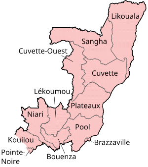
Map of the regions of the Republic of the Congo, named in French (local language), mostly compatible with English. The individual maps are: |
| Data | |
| Sors | Self-made, traced from public domain UN or CIA maps. |
| Awtur | User:Golbez |
| Permess (Użu mill-ġdid tal-fajl) |
Provide attribution, please. See below. |
Jiena, id-detentur tal-copyright ta' dan ix-xogħol, niddikjara li se nippubblikah taħt il-liċenzji segwenti:
Dan il-fajl huwa liċenzjat taħt it-termini tal-liċenzja Creative Commons Attribuzzjoni-Aqsam bl-istess mod 2.5 Ġeneriku, 2.0 Ġeneriku and 1.0 Ġeneriku
- Inti ħieles:
- li taqsam – li tikkopja, tiddistribwixxi u tittrażmetti din l-opra
- li timmodifika – li tadatta l-biċċa xogħol
- Taħt il-kundizzjonijiet segwenti:
- attribuzzjoni – Għandek tattribwixxi x-xogħol bil-mod speċifikat mill-awtur jew minn min ta l-l-iċenzja (imma mhux b'xi mod li jissuġġerixxi ji jappoġjaw lilek jew l-użu tax-xogħol).
- Ixxerja bl-istess mod – Jekk tbiddel, tittrasforma jew tibni fuq dan il-materjal, inti għandek bżonn taqsam il-kontribuzzjonijiet tiegħek taħt l-istess liċenzja jew waħda li taqbel ma' dik oriġinali.

|
Huwa permess li tikkopja, tiddistribwixxi u/jew timmodifika dan id-dokument abbażi tat-termini tal-Liċenzja ta' Dokumentazzjoni Ħielsa tal-GNU, Verżjoni 1.2 jew kwalunkwe verżjoni oħra pubblikata mill-Free Software Foundation; mingħajr ebda sezzjoni non-modifikabbli, mingħajr test tal-faċċata u mingħajr test tal-qoxra. Kopja tal-liċenzja hi inkluża fis-sezzjoni intitolata Test tal-Liċenzja ta' Dokumentazzjoni Ħielsa tal-GNU". |
| Dan il-fajl huwa liċenzjat taħt it-termini tal-liċenzja Creative Commons Attribuzzjoni-Aqsam bl-istess mod 3.0 Unported | ||
| ||
| This licensing tag was added to this file as part of the GFDL licensing update. |
Tista' tagħżel il-liċenzja li tippreferi.
Kronoloġija tal-fajl
Agħfas fuq il-grupp data/ħin biex tara l-fajl biex tara kif jidher dak il-ħin.
| Data/Ħin | Minjatura | Qisien | Utent | Kumment | |
|---|---|---|---|---|---|
| kurrenti | 17:29, 1 Ottubru 2023 | | 300 × 337 (14 KB) | Yunan973 | fix all boundaries according to last offical maps (2023) |
| 16:53, 28 Diċembru 2004 |  | 300 × 370 (13 KB) | Golbez | Map of the regions of the Republic of the Congo. Made by User:Golbez. {{cc-by-sa-2.0}} |
Użu tal-fajl
Il-Paġna segwenti twassal għal din l-istampa:
L-użu globali tal-fajl
Il-wikis segwenti jużaw dan il-fajl:
- Użu fuq ast.wikipedia.org
- Użu fuq avk.wikipedia.org
- Użu fuq be-tarask.wikipedia.org
- Użu fuq bg.wikipedia.org
- Użu fuq bn.wikipedia.org
- Użu fuq br.wikipedia.org
- Użu fuq ca.wikipedia.org
- Użu fuq de.wikipedia.org
- Użu fuq el.wikipedia.org
- Użu fuq en.wikipedia.org
- Departments of the Republic of the Congo
- Pointe-Noire
- Districts of the Republic of the Congo
- User:Jonny-mt/Gallery of current first-level administrative country subdivisions maps
- Kimongo District
- Mayoko District
- Divénié District
- Louvakou District
- Template:Districts of the Republic of the Congo
- User talk:Markussep/Archive 4
- Kibangou District
- Moutamba District
- Boko-Songho District
- Loudima District
- Madingou District
- Mfouati District
- Mouyondzi District
- Kayes District
- Boundji District
- Loukela District
- Makoua District
- Mossaka District
- Okoyo District
- Oyo District
- Ewo District
- Kelle District
- Mbomo District
- Kakamoeka District
- Madingo-Kayes District
- Mvouti District
- Bambama District
- Komono District
- Sibiti District
- Zanaga District
- Dongou District
- Epena District
- Impfondo District
Ara l-użu globali ta' dan il-fajl.