Stampa:City of London skyline from London City Hall - Oct 2008.jpg

Daqs tad-dehra proviżorja: 800 × 420 pixels. Riżoluzzjonijiet oħra: 320 × 168 pixels | 640 × 336 pixels | 1,024 × 537 pixels | 1,280 × 671 pixels | 2,560 × 1,343 pixels | 8,441 × 4,427 pixels
Fajl oriġinali (8,441 × 4,427 pixel, dimensjoni: 10.81 MB, tip ta' MIME: image/jpeg)
| Dan huwa fajl mill-Wikimedia Commons. Il-deskrizzjoni fuq il-paġna ta' diskussjoni oriġinali tidher hawn taħt.
|
Taqsira
| Deskrizzjoni |
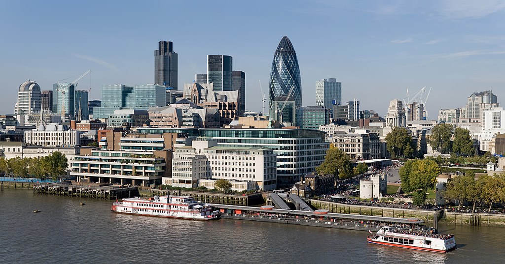
English: The City of London skyline as viewed toward the north-west from the top floor viewing platform of London City Hall on the southern side of the Thames. In the foreground: Dixie Queen and Millennium Time at Tower Millennium Pier. This is a 5 segment panoramic image taken by myself with a Canon 5D and 24-105mm f/4L IS lens. |
| Data | |
| Sors | Opra proprja |
| Awtur | Diliff |
| Permess (Użu mill-ġdid tal-fajl) |
Summary:In using this image or any subsequent derivatives of it, you are required to release the image under the same license. As such, any reproduction of this image, in any medium, must appear with a copy of, or full URL of the license.Attribution of this image to the author (DAVID ILIFF) is also required, preferably in a prominent location near the image.No other conditions may be added to, or removed from this license without the permission of the author and copyright holder.Suggested attribution: "Photo by DAVID ILIFF. License: CC BY-SA 3.0"Please review the full license requirements carefully before using this image. If you would like to clarify the terms of the license or negotiate less restrictive commercial licensing outside of the bounds of GFDL/CC-BY-SA, please contact me by email, or if you don't have a Wikipedia account you can either leave a message on my talk page with your contact details and your request, or you can contact me on Facebook. Please also send a 'friend request' to ensure that I am aware of your message. |
| Verżjonijiet oħra |
  |
| Camera location | | View this and other nearby images on: OpenStreetMap |
|---|
Liċenzja
Jiena, id-detentur tal-copyright ta' dan ix-xogħol, niddikjara li se nippubblikah taħt il-liċenzji segwenti:
Dan il-fajl huwa liċenzjat taħt it-termini tal-liċenzja Creative Commons Attribuzzjoni-Aqsam bl-istess mod 3.0 Unported
- Inti ħieles:
- li taqsam – li tikkopja, tiddistribwixxi u tittrażmetti din l-opra
- li timmodifika – li tadatta l-biċċa xogħol
- Taħt il-kundizzjonijiet segwenti:
- attribuzzjoni – Għandek tattribwixxi x-xogħol bil-mod speċifikat mill-awtur jew minn min ta l-l-iċenzja (imma mhux b'xi mod li jissuġġerixxi ji jappoġjaw lilek jew l-użu tax-xogħol).
- Ixxerja bl-istess mod – Jekk tbiddel, tittrasforma jew tibni fuq dan il-materjal, inti għandek bżonn taqsam il-kontribuzzjonijiet tiegħek taħt l-istess liċenzja jew waħda li taqbel ma' dik oriġinali.

|
Huwa permess li tikkopja, tiddistribwixxi u/jew timmodifika dan id-dokument abbażi tat-termini tal-Liċenzja ta' Dokumentazzjoni Ħielsa tal-GNU, Verżjoni 1.2 jew kwalunkwe verżjoni oħra pubblikata mill-Free Software Foundation; mingħajr ebda sezzjoni non-modifikabbli, mingħajr test tal-faċċata u mingħajr test tal-qoxra. Kopja tal-liċenzja hi inkluża fis-sezzjoni intitolata Test tal-Liċenzja ta' Dokumentazzjoni Ħielsa tal-GNU". |
Tista' tagħżel il-liċenzja li tippreferi.
Assessment
|
This image has been assessed using the Quality image guidelines and is considered a Quality image.
|
| Annotations | This image is annotated: View the annotations at Commons |
Kronoloġija tal-fajl
Agħfas fuq il-grupp data/ħin biex tara l-fajl biex tara kif jidher dak il-ħin.
| Data/Ħin | Minjatura | Qisien | Utent | Kumment | |
|---|---|---|---|---|---|
| kurrenti | 07:41, 24 Ġunju 2012 | | 8,441 × 4,427 (10.81 MB) | Tim! | Reverted to version as of 12:54, 12 October 2008 |
| 12:54, 12 Ottubru 2008 |  | 8,441 × 4,427 (10.81 MB) | Diliff | {{Information |Description={{en|1=The City of London skyline as viewed toward the north-west from the top floor viewing platform of London City Hall on the southern side of the Thames. This is a 5 segment panoramic image taken by myself with a Canon 5D an |
Użu tal-fajl
L-ebda paġna fuq il-Wikipedija Maltija torbot lejn dan il-fajl.
L-użu globali tal-fajl
Il-wikis segwenti jużaw dan il-fajl:
- Użu fuq af.wikipedia.org
- Użu fuq ar.wikipedia.org
- Użu fuq az.wikipedia.org
- Użu fuq az.wiktionary.org
- Użu fuq be-tarask.wikipedia.org
- Użu fuq be.wikipedia.org
- Użu fuq bg.wikipedia.org
- Użu fuq bs.wikipedia.org
- Użu fuq ca.wikipedia.org
- Użu fuq cy.wikipedia.org
- Użu fuq de.wikipedia.org
- Użu fuq en.wikipedia.org
- Tower Millennium Pier
- Wikipedia:WikiProject UK geography
- Wikipedia talk:WikiProject UK geography
- User:Diliff
- Portal:London/Pictures/Wikipedia featured pictures
- Wikipedia:Featured pictures/Places/Panorama
- Portal:United Kingdom/Featured picture
- Wikipedia:WikiProject UK geography/Announcements
- Wikipedia:Featured pictures thumbs/13
- Metropolis
- Wikipedia:Featured picture candidates/October-2008
- Wikipedia:Featured picture candidates/City of London skyline
- Wikipedia:Wikipedia Signpost/2008-11-08/Features and admins
- Wikipedia:Wikipedia Signpost/2008-11-08/SPV
- Wikipedia:Picture of the day/June 2009
- Template:POTD/2009-06-08
- User talk:Diliff/Archive6
- List of central business districts
- Wake Up to Money
- User:Quibik/Montage
- Portal:London/Featured picture
- Portal:London/Featured picture/12
- User talk:Sabrebd/Autoarchive 4
- Talk:United Kingdom/Archive 27
- User talk:Ottoniel B
- Portal:United Kingdom/Featured picture/47
- Talk:London/Archive 11
- Template:User Part Time Resident-London
- User:DexDor/Categorization
Ara l-użu globali ta' dan il-fajl.