Stampa:Caucasus 1245 AD map de.png
Daqs tad-dehra proviżorja: 771 × 600 pixels. Riżoluzzjonijiet oħra: 309 × 240 pixels | 617 × 480 pixels | 988 × 768 pixels | 1,280 × 995 pixels | 2,560 × 1,991 pixels | 2,995 × 2,329 pixels
Fajl oriġinali (2,995 × 2,329 pixel, dimensjoni: 3.48 MB, tip ta' MIME: image/png)
| Dan huwa fajl mill-Wikimedia Commons. Il-deskrizzjoni fuq il-paġna ta' diskussjoni oriġinali tidher hawn taħt.
|
Taqsira
| Deskrizzjoni |
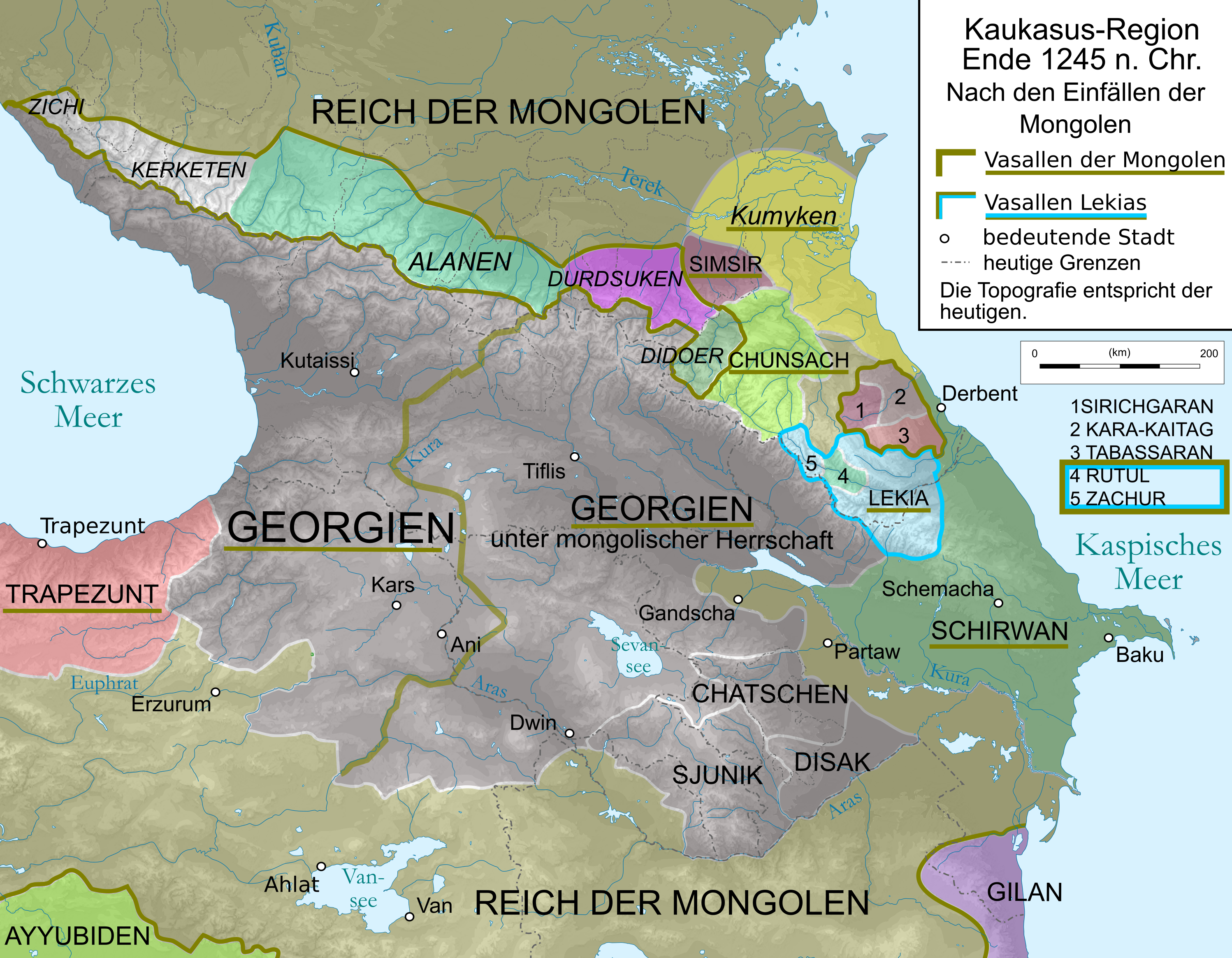
English: Map of Caucasus Region around 1380 in German.
Deutsch: Kaukasus-Region um 1311 n. Chr. Quellen sind: * Michael Kemper: Herrschaft, Recht und Islam in Daghestan. Von den Khanaten und Gemeindebünden zum ǧihād-Staat. Wiesbaden 2005. S. 30–111.
|
| Data | |
| Sors | Own work by uploader, derivate of File:Caucasus_topographic_map-fr.svg |
| Awtur | Don-kun and WajWohu |
| Verżjonijiet oħra |
 |
Liċenzja
Jiena, id-detentur tal-copyright ta' dan ix-xogħol, niddikjara li se nippubblikah taħt il-liċenzji segwenti:

|
Huwa permess li tikkopja, tiddistribwixxi u/jew timmodifika dan id-dokument abbażi tat-termini tal-Liċenzja ta' Dokumentazzjoni Ħielsa tal-GNU, Verżjoni 1.2 jew kwalunkwe verżjoni oħra pubblikata mill-Free Software Foundation; mingħajr ebda sezzjoni non-modifikabbli, mingħajr test tal-faċċata u mingħajr test tal-qoxra. Kopja tal-liċenzja hi inkluża fis-sezzjoni intitolata Test tal-Liċenzja ta' Dokumentazzjoni Ħielsa tal-GNU". |
Dan il-fajl huwa liċenzjat taħt it-termini tal-liċenzja Creative Commons Attribuzzjoni-Aqsam bl-istess mod 3.0 Unported, 2.5 Ġeneriku, 2.0 Ġeneriku u 1.0 Ġeneriku
- Inti ħieles:
- li taqsam – li tikkopja, tiddistribwixxi u tittrażmetti din l-opra
- li timmodifika – li tadatta l-biċċa xogħol
- Taħt il-kundizzjonijiet segwenti:
- attribuzzjoni – Għandek tattribwixxi x-xogħol bil-mod speċifikat mill-awtur jew minn min ta l-l-iċenzja (imma mhux b'xi mod li jissuġġerixxi ji jappoġjaw lilek jew l-użu tax-xogħol).
- Ixxerja bl-istess mod – Jekk tbiddel, tittrasforma jew tibni fuq dan il-materjal, inti għandek bżonn taqsam il-kontribuzzjonijiet tiegħek taħt l-istess liċenzja jew waħda li taqbel ma' dik oriġinali.
Tista' tagħżel il-liċenzja li tippreferi.
Kronoloġija tal-fajl
Agħfas fuq il-grupp data/ħin biex tara l-fajl biex tara kif jidher dak il-ħin.
| Data/Ħin | Minjatura | Qisien | Utent | Kumment | |
|---|---|---|---|---|---|
| kurrenti | 19:52, 22 Ġunju 2020 | | 2,995 × 2,329 (3.48 MB) | Don-kun | corrections according to discussions, sources will follow |
| 15:20, 6 Ottubru 2010 |  | 3,000 × 2,332 (3.53 MB) | Don-kun | {{Information |Description={{en|1=Map of Caucasus Region around 1245 AD in German.}} {{de|1=Kaukasus-Region um 1213 n. Chr. Westlicher Teil Georgiens unter direkter Herrschaft des georgischen Königs als Vasall der Mongolen, östlicher Teil unter mongolis |
Użu tal-fajl
Il-Paġna segwenti twassal għal din l-istampa:
L-użu globali tal-fajl
Il-wikis segwenti jużaw dan il-fajl:
- Użu fuq als.wikipedia.org
- Użu fuq az.wikipedia.org
- Użu fuq de.wikipedia.org
- Użu fuq en.wikipedia.org
- Użu fuq hu.wikipedia.org
- Użu fuq ka.wikipedia.org
- Użu fuq lv.wikipedia.org
- Użu fuq sr.wikipedia.org
- Użu fuq tr.wikipedia.org
- Użu fuq uk.wikipedia.org