Stampa:Caspian Forests (207720547).jpeg

Daqs tad-dehra proviżorja: 800 × 554 pixels. Riżoluzzjonijiet oħra: 320 × 221 pixels | 640 × 443 pixels | 1,024 × 709 pixels | 1,280 × 886 pixels | 2,048 × 1,417 pixels
Fajl oriġinali (2,048 × 1,417 pixel, dimensjoni: 1.5 MB, tip ta' MIME: image/jpeg)
| Dan huwa fajl mill-Wikimedia Commons. Il-deskrizzjoni fuq il-paġna ta' diskussjoni oriġinali tidher hawn taħt.
|
.jpeg)
Taqsira
| Caspian Forests | |
|---|---|
| Fotografu | |
| Titlu |
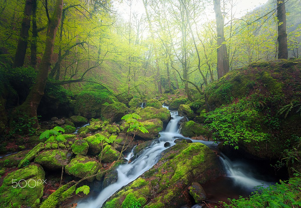
Caspian Forests |
| Deskrizzjoni |
500px provided description: "Hyrcanian forests " ' Hyrcanian Forest ' contains remnants (refugia) of the broad leaf forests that once covered most of the North Temperate Zone 25 - 50 million years ago, in the early Cenozoic Era. As the climate and land forms changed, this forest disappeared from most of its former range, being replaced by shrublands, grasslands, and woodlands. During the Pleistocene ("Ice Ages"), glaciations had minimal impact on Hyrcanian Forest. North of Iran as along band has diverse natural, economic and social conditions. Hyrcanian forest contain the most important and significant natural habitats for in-situ conservation of biological diversity, including those containing threatened species of outstanding universal value from the point of view of science or conservation." The Caspian forest "(North of Iran) areas are among the most unique and splendid biomes of the world. The Caspian forests have high moisture content, so forest trees are host to many epiphytes such as mosses, ferns, lichens, mistletoes and some flowering plants. Soils are productive and rich in minerals and organic matter [#landscape ,#fog ,#forest ,#spring ,#nature ,#river ,#tree ,#long exposure ,#fine art ,#iran] |
| Data | 7 April 2017, 17:09:06 |
| Sors | Imported from 500px (archived version) by the Archive Team. (detail page) |
| Permess (Użu mill-ġdid tal-fajl) |
Dan il-fajl huwa liċenzjat taħt it-termini tal-liċenzja Creative Commons Attribuzzjoni-Aqsam bl-istess mod 3.0 Unported
|
| Camera location | | View this and other nearby images on: OpenStreetMap |
|---|
.jpeg¶ms=037.280946_N_0049.592413_E_globe:Earth_type:camera__&language=mt)
Kronoloġija tal-fajl
Agħfas fuq il-grupp data/ħin biex tara l-fajl biex tara kif jidher dak il-ħin.
| Data/Ħin | Minjatura | Qisien | Utent | Kumment | |
|---|---|---|---|---|---|
| kurrenti | 12:00, 1 Novembru 2019 | | 2,048 × 1,417 (1.5 MB) | Rodrigo.Argenton | Photo Caspian Forests imported from 500px with import-500px |
Użu tal-fajl
Il-Paġna segwenti twassal għal din l-istampa:
L-użu globali tal-fajl
Il-wikis segwenti jużaw dan il-fajl:
- Użu fuq az.wikipedia.org
- Użu fuq bn.wikipedia.org
- Użu fuq en.wikipedia.org
- Użu fuq fa.wikipedia.org
- Użu fuq ml.wikipedia.org
- Użu fuq pt.wikipedia.org
- Użu fuq sh.wikipedia.org
- Użu fuq sl.wikipedia.org
.jpeg)