Stampa:British Guiana - 1908 - WDL.png

Daqs tad-dehra proviżorja: 376 × 600 pixels. Riżoluzzjonijiet oħra: 150 × 240 pixels | 301 × 480 pixels | 481 × 768 pixels | 642 × 1,024 pixels | 1,283 × 2,048 pixels | 4,080 × 6,510 pixels
Fajl oriġinali (4,080 × 6,510 pixel, dimensjoni: 32.48 MB, tip ta' MIME: image/png)
| Dan huwa fajl mill-Wikimedia Commons. Il-deskrizzjoni fuq il-paġna ta' diskussjoni oriġinali tidher hawn taħt.
|
Taqsira
| Deskrizzjoni |
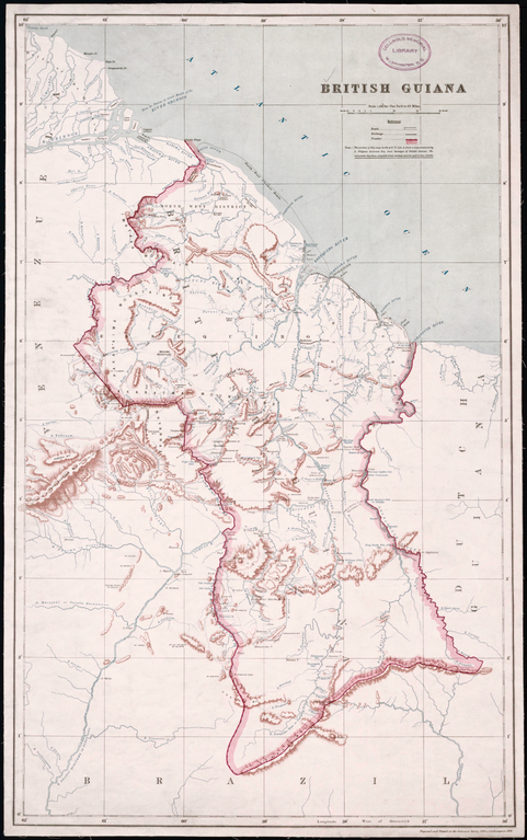
English: British Guiana, 1908
Creator: Great Britain. Ordnance Survey Surveyor: Anderson, Charles Wilgress "This map, prepared and printed in 1908 at the office of the Ordnance Survey, Southampton, United Kingdom, provides a relatively detailed view of the geography of British Guiana (present-day Guyana), one of only two British colonies on the mainland of South and Central America (the other being British Honduras). A note indicates that the portion of the map north of 5° North latitude is from a map prepared by the government surveyor of British Guiana, while the remainder of the map “has been compiled from various sources and is less reliable.” Much of the territory in the south of the country was as yet unexplored. Bordered to the west by Venezuela, to the south by Brazil, and to the east by Dutch Guiana (present-day Suriname), British Guiana was the subject of a longstanding border dispute with Venezuela, in which the United States became involved and that was settled by arbitration in 1899. The map reflects the settlement, which awarded Britain most of the disputed territory but gave Venezuela undisputed control over the Orinoco River. The map shows international borders, cities and towns, railroads, posts and forts, and physical features such as rivers, cataracts, and hills and mountains." |
| Data | |
| Sors | http://www.wdl.org/en/item/11328/ |
| Awtur | Great Britain. Ordnance Survey |
Liċenzja
Dan il-fajl jinsab fid-dominju pubbliku ġewwa l-Istati Uniti. Dan japplika għall-opri Statunitensi li l-copyright tagħhom skada, ħafna drabi minħabba li l-ewwel pubblikazzjoni tagħhom saret qabel l-1 ta' Jannar 1929. Ara din il-paġna għal aktar informazzjoni.
|
 | |
 |
Din l-istampa tista' ma tkunx fid-dominju pubbliku barra mill-Istati Uniti (partikularment fil-Kanada, iċ-Ċina (mhux Ħong Kong, il-Makaw jew it-Tajwan), il-Ġermanja, il-Messiku u l-Iżvizzera). L-awtur u s-sena tal-pubblikazzjoni huma informazzjoni essenzjali u jridu jiġu forniti. Ara Wikipedia:Public domain u Wikipedia:Copyrights għal aktar dettalji.
|
Kronoloġija tal-fajl
Agħfas fuq il-grupp data/ħin biex tara l-fajl biex tara kif jidher dak il-ħin.
| Data/Ħin | Minjatura | Qisien | Utent | Kumment | |
|---|---|---|---|---|---|
| kurrenti | 08:58, 18 Jannar 2020 | | 4,080 × 6,510 (32.48 MB) | ZiaLater | More detailed version |
| 20:39, 23 Ottubru 2013 |  | 1,024 × 1,631 (2.71 MB) | SarahStierch | User created page with UploadWizard |
Użu tal-fajl
Il-Paġna segwenti twassal għal din l-istampa:
L-użu globali tal-fajl
Il-wikis segwenti jużaw dan il-fajl:
- Użu fuq en.wikipedia.org
- Użu fuq eo.wikipedia.org
- Użu fuq es.wikipedia.org
- Użu fuq fa.wikipedia.org
- Użu fuq fr.wikipedia.org
- Użu fuq he.wikipedia.org
- Użu fuq hr.wikipedia.org
- Użu fuq is.wikipedia.org
- Użu fuq it.wikipedia.org
- Użu fuq ms.wikipedia.org
- Użu fuq pt.wikipedia.org
- Użu fuq ru.wikipedia.org
- Użu fuq zh.wikipedia.org