Stampa:Balkans 6th century.svg

Size of this PNG preview of this SVG file: 800 × 431 pixels. Riżoluzzjonijiet oħra: 320 × 173 pixels | 640 × 345 pixels | 1,024 × 552 pixels | 1,280 × 690 pixels | 2,560 × 1,381 pixels | 1,400 × 755 pixels
Fajl oriġinali (Fajl fil-format SVG, dimensjoni nominali 1,400 × 755 pixel, dimensjoni tal-fajl: 1.83 MB)
| Dan huwa fajl mill-Wikimedia Commons. Il-deskrizzjoni fuq il-paġna ta' diskussjoni oriġinali tidher hawn taħt.
|
Taqsira
| Deskrizzjoni |
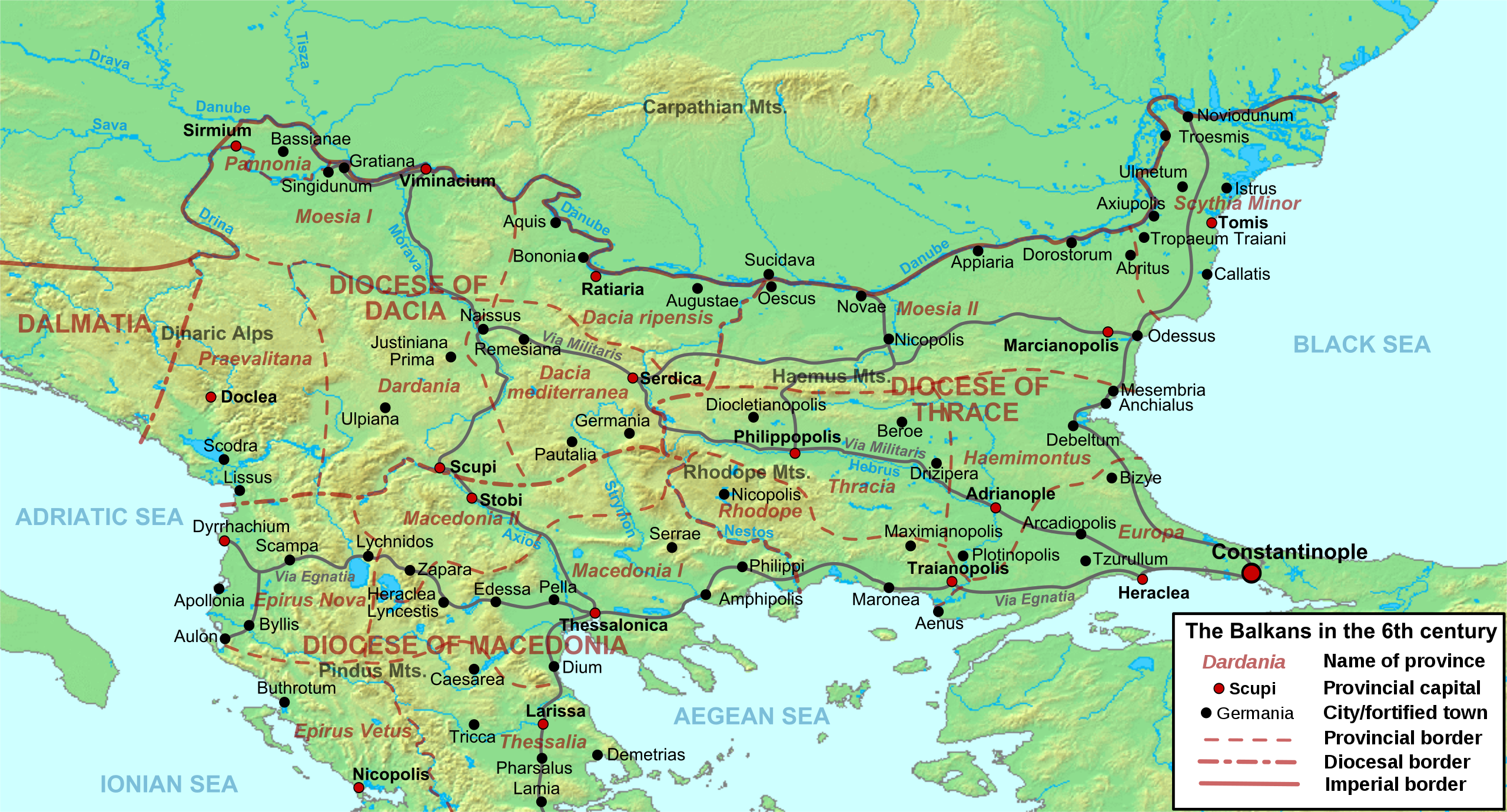
Deutsch: Die nördliche Balkanhalbinsel in der Spätantike (6. Jahrhundert), mit den spätrömischen Provinzen, Hauptsiedlungen und Straẞen.
English: Map of the northern Balkans in the 6th century AD, with the Roman provinces, major settlements and roads.
Français : Carte des Balkans septentrionaux au VIe siècle, à la veille de l'arrivée des Slaves, avec les provinces romains, les villes et les routes les plus importantes. |
| Data | |
| Sors |
Opra proprja based on:
|
| Awtur | Cplakidas |
| Verżjonijiet oħra |
[]
|


Liċenzja
Jiena, id-detentur tal-copyright ta' dan ix-xogħol, niddikjara li se nippubblikah taħt il-liċenzji segwenti:
Dan il-fajl huwa liċenzjat taħt it-termini tal-liċenzja Creative Commons Attribuzzjoni-Aqsam bl-istess mod 3.0 Unported
- Inti ħieles:
- li taqsam – li tikkopja, tiddistribwixxi u tittrażmetti din l-opra
- li timmodifika – li tadatta l-biċċa xogħol
- Taħt il-kundizzjonijiet segwenti:
- attribuzzjoni – Għandek tattribwixxi x-xogħol bil-mod speċifikat mill-awtur jew minn min ta l-l-iċenzja (imma mhux b'xi mod li jissuġġerixxi ji jappoġjaw lilek jew l-użu tax-xogħol).
- Ixxerja bl-istess mod – Jekk tbiddel, tittrasforma jew tibni fuq dan il-materjal, inti għandek bżonn taqsam il-kontribuzzjonijiet tiegħek taħt l-istess liċenzja jew waħda li taqbel ma' dik oriġinali.

|
Huwa permess li tikkopja, tiddistribwixxi u/jew timmodifika dan id-dokument abbażi tat-termini tal-Liċenzja ta' Dokumentazzjoni Ħielsa tal-GNU, Verżjoni 1.2 jew kwalunkwe verżjoni oħra pubblikata mill-Free Software Foundation; mingħajr ebda sezzjoni non-modifikabbli, mingħajr test tal-faċċata u mingħajr test tal-qoxra. Kopja tal-liċenzja hi inkluża fis-sezzjoni intitolata Test tal-Liċenzja ta' Dokumentazzjoni Ħielsa tal-GNU". |
Tista' tagħżel il-liċenzja li tippreferi.
Kronoloġija tal-fajl
Agħfas fuq il-grupp data/ħin biex tara l-fajl biex tara kif jidher dak il-ħin.
| Data/Ħin | Minjatura | Qisien | Utent | Kumment | |
|---|---|---|---|---|---|
| kurrenti | 09:52, 11 Mejju 2012 | | 1,400 × 755 (1.83 MB) | Cplakidas | corrected locations of Thracia and Haemimontus, minor tweaks elsewhere |
| 20:27, 7 Jannar 2012 |  | 1,400 × 755 (1.91 MB) | Cplakidas | Left-over names to paths | |
| 20:29, 1 Marzu 2010 |  | 1,400 × 755 (2.1 MB) | Cplakidas | names to paths | |
| 20:20, 1 Marzu 2010 |  | 1,400 × 755 (1.08 MB) | Cplakidas | {{Information |Description={{en|1=Map of the northern Balkans in the 6th century AD. Geophysical map taken from from [http://www2.demis.nl/mapserver/mapper.asp DEMIS Mapserver], which are public domain, other wise self-made. Sources: [http://soltdm.com/so |
Użu tal-fajl
Il-Paġna segwenti twassal għal din l-istampa:
L-użu globali tal-fajl
Il-wikis segwenti jużaw dan il-fajl:
- Użu fuq ar.wikipedia.org
- Użu fuq azb.wikipedia.org
- Użu fuq be.wikipedia.org
- Użu fuq bg.wikipedia.org
- Użu fuq bs.wikipedia.org
- Użu fuq cs.wikipedia.org
- Użu fuq de.wikipedia.org
- Użu fuq el.wikipedia.org
- Użu fuq en.wikipedia.org
- History of Albania
- 593
- Maurice (emperor)
- Moesia
- Dardani
- Serbia in the Middle Ages
- Pannonia (Byzantine province)
- Dacia Ripensis
- Dacia Mediterranea
- Dacia Aureliana
- Diocese of Dacia
- Praevalitana
- Peter (curopalates)
- Maurice's Balkan campaigns
- Dardania (Roman province)
- Ratiaria
- Via Militaris
- Comentiolus
- Albania under the Byzantine Empire
Ara l-użu globali ta' dan il-fajl.