Stampa:Arabia Armistice Mudros.png

Fajl oriġinali (3,242 × 3,572 pixel, dimensjoni: 1.12 MB, tip ta' MIME: image/png)
| Dan huwa fajl mill-Wikimedia Commons. Il-deskrizzjoni fuq il-paġna ta' diskussjoni oriġinali tidher hawn taħt.
|
Taqsira
| Deskrizzjoni |
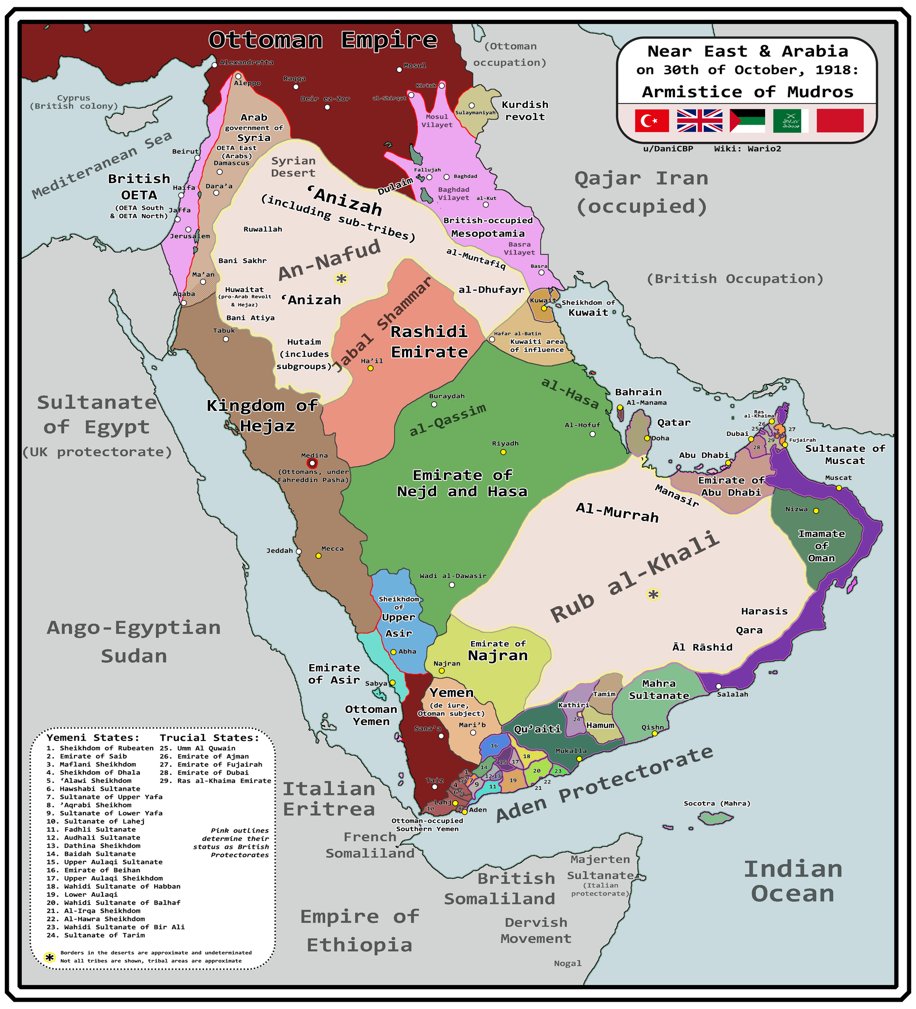
English: Map of Arabia and the Near East at the end of World War I, in October 30th, 1918, day of the Armistice of Mudros. |
| Data | |
| Sors |
Opra proprja + Ashkenazi, T. (1948). The ’Anazah Tribes. Southwestern Journal of Anthropology, 4(2), 222–239. http://www.jstor.org/stable/3628713 H. St. J. B. Philby. (1920). Southern Najd. The Geographical Journal, 55(3), 161–185. https://doi.org/10.2307/1781600 Haines, S. B. (1839). Memoir, to Accompany a Chart of the South Coast of Arabia from the Entrance of the Red Sea to Misenát, in 50° 43′ 25″ E. The Journal of the Royal Geographical Society of London, 9, 125–156. https://doi.org/10.2307/1797718 Helfritz, H. (1935). The First Crossing of Southwestern Arabia. Geographical Review, 25(3), 395–407. https://doi.org/10.2307/209308 Thomas, B. (1929). Among Some Unknown Tribes of South Arabia. The Journal of the Royal Anthropological Institute of Great Britain and Ireland, 59, 97–111. https://doi.org/10.2307/2843560 Anderson, S. (2014). Lawrence in Arabia: War, Deceit, Imperial Folly and the Making of the Modern Middle East. Atlantic Books Ltd. Boxberger, L. (2012). On the Edge of Empire: Hadhramawt, Emigration, and the Indian Ocean, 1880s–1930s. SUNY Press. J. E. Peterson. (1976) "The Revival of the Ibadi Imamate in Oman and the Threat to Muscat, 1913–20," Arabian Studies 3 Al-Maghafi, Fadhl (2012). "MORE THAN JUST A BOUNDARY DISPUTE: THE REGIONAL GEOPOLITICS OF SAUDI-YEMENI RELATIONS" (PDF). eprints.soas.ac.uk Bang, Anne (1997). The Idrisi State in Asir 1906–1934. Hurst Publishers. pp. 111–114. ISBN 9781850653066. Eskander, S. "Britain's Policy Towards The Kurdish Question, 1915-1923" (PDF). etheses.lse.ac.uk. |
| Awtur | Wario2 |
Liċenzja
- Inti ħieles:
- li taqsam – li tikkopja, tiddistribwixxi u tittrażmetti din l-opra
- li timmodifika – li tadatta l-biċċa xogħol
- Taħt il-kundizzjonijiet segwenti:
- attribuzzjoni – Għandek tattribwixxi x-xogħol bil-mod speċifikat mill-awtur jew minn min ta l-l-iċenzja (imma mhux b'xi mod li jissuġġerixxi ji jappoġjaw lilek jew l-użu tax-xogħol).
Kronoloġija tal-fajl
Agħfas fuq il-grupp data/ħin biex tara l-fajl biex tara kif jidher dak il-ħin.
| Data/Ħin | Minjatura | Qisien | Utent | Kumment | |
|---|---|---|---|---|---|
| kurrenti | 10:18, 13 Marzu 2024 | | 3,242 × 3,572 (1.12 MB) | Wario2 | Uploaded own work with UploadWizard |
Użu tal-fajl
Il-Paġna segwenti twassal għal din l-istampa:
L-użu globali tal-fajl
Il-wikis segwenti jużaw dan il-fajl:
- Użu fuq ar.wikipedia.org
- Użu fuq en.wikipedia.org
- Użu fuq es.wikipedia.org