Stampa:A new map of Virginia, Maryland, and the improved parts of Pennsylvania & New Jersey. LOC 2005630923.jpg

Daqs tad-dehra proviżorja: 675 × 600 pixels. Riżoluzzjonijiet oħra: 270 × 240 pixels | 540 × 480 pixels | 865 × 768 pixels | 1,153 × 1,024 pixels | 2,306 × 2,048 pixels | 6,920 × 6,147 pixels
Fajl oriġinali (6,920 × 6,147 pixel, dimensjoni: 7.25 MB, tip ta' MIME: image/jpeg)
| Dan huwa fajl mill-Wikimedia Commons. Il-deskrizzjoni fuq il-paġna ta' diskussjoni oriġinali tidher hawn taħt.
|
Taqsira
| Deskrizzjoni |
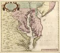
English: Relief shown pictorially. Depths shown by soundings. Date and attribution from On the Map, 1983 (Figure 24). First state of map published originally in 1685 by Christopher Browne with the imprint in the cartouche under the title. No longitude lines are given. Available also through the Library of Congress Web site as a raster image. LC copy annotated with pencil in bottom margin. Stamped and annotated in blue ink on verso: 24. LC copy imperfect: Loose binding along bottom margin. |
||
| Title | A new map of Virginia, Maryland, and the improved parts of Pennsylvania & New Jersey. | ||
| Shelf ID | G3790 1685 .B7 | ||
| Data | |||
| Sors | https://www.loc.gov/item/2005630923/ | ||
| Awtur | Browne, Christopher | ||
| Permess (Użu mill-ġdid tal-fajl) |
|
||
| Verżjonijiet oħra |
|
||
| Location | Pennsylvania · Virginia · United States · New Jersey · Middle Atlantic States · Maryland | ||
| Part of | American Memory · General Maps · Catalog · Geography And Map Division | ||
| Subject | Pennsylvania · Virginia · New Jersey · United States · Maps · Early Works To 1800 · Middle Atlantic States · Maryland |

.jpg)
Liċenzja
|
This is a faithful photographic reproduction of a two-dimensional, public domain work of art. The work of art itself is in the public domain for the following reason:
The official position taken by the Wikimedia Foundation is that "faithful reproductions of two-dimensional public domain works of art are public domain".
This photographic reproduction is therefore also considered to be in the public domain in the United States. In other jurisdictions, re-use of this content may be restricted; see Reuse of PD-Art photographs for details. | ||||
Kronoloġija tal-fajl
Agħfas fuq il-grupp data/ħin biex tara l-fajl biex tara kif jidher dak il-ħin.
| Data/Ħin | Minjatura | Qisien | Utent | Kumment | |
|---|---|---|---|---|---|
| kurrenti | 10:19, 22 Lulju 2018 | | 6,920 × 6,147 (7.25 MB) | Fæ | LOC Maps https://www.loc.gov/item/2005630923/ #8007 |
Użu tal-fajl
L-ebda paġna fuq il-Wikipedija Maltija torbot lejn dan il-fajl.