Stampa:Wfm firth of forth.jpg

Daqs tad-dehra proviżorja: 800 × 593 pixels. Riżoluzzjonijiet oħra: 320 × 237 pixels | 640 × 474 pixels | 1,024 × 758 pixels | 1,280 × 948 pixels
Fajl oriġinali (1,280 × 948 pixel, dimensjoni: 289 KB, tip ta' MIME: image/jpeg)
| Dan huwa fajl mill-Wikimedia Commons. Il-deskrizzjoni fuq il-paġna ta' diskussjoni oriġinali tidher hawn taħt.
|
Taqsira
| Deskrizzjoni |
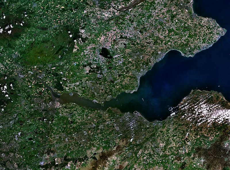
English: The Firth of the river Forth, on the east coast of Scotland. The two forth bridges are visible near the centre of the frame. Stirling is at the extreme left side. |
| Data | 3 Awwissu 2005 (upload date) |
| Sors | Satellite imagery taken by screenshot from NASA World Wind software |
| Awtur | NASA |
Liċenzja
| This image is in the public domain because it is a screenshot from NASA’s globe software World Wind using a public domain layer, such as Blue Marble, MODIS, Landsat, SRTM, USGS or GLOBE.
|
 |
Kronoloġija tal-fajl
Agħfas fuq il-grupp data/ħin biex tara l-fajl biex tara kif jidher dak il-ħin.
| Data/Ħin | Minjatura | Qisien | Utent | Kumment | |
|---|---|---|---|---|---|
| kurrenti | 09:38, 3 Awwissu 2005 | | 1,280 × 948 (289 KB) | Finlay McWalter | The Firth of the river Forth, on the east coast of Scotland. The two forth bridges are visible near the centre of the frame. Stirling is at the extreme left side. Image made with NASA World Wind. {{PD-USGov-NASA}} category:satellite photos |
Użu tal-fajl
Il-Paġna segwenti twassal għal din l-istampa:
L-użu globali tal-fajl
Il-wikis segwenti jużaw dan il-fajl:
- Użu fuq ar.wikipedia.org
- Użu fuq be.wikipedia.org
- Użu fuq bg.wikipedia.org
- Użu fuq br.wikipedia.org
- Użu fuq ca.wikipedia.org
- Użu fuq ceb.wikipedia.org
- Użu fuq cs.wikipedia.org
- Użu fuq cy.wikipedia.org
- Użu fuq de.wikipedia.org
- Użu fuq el.wikipedia.org
- Użu fuq en.wikipedia.org
- Użu fuq en.wikivoyage.org
- Użu fuq eo.wikipedia.org
- Użu fuq es.wikipedia.org
- Użu fuq et.wikipedia.org
- Użu fuq eu.wikipedia.org
- Użu fuq fa.wikipedia.org
- Użu fuq fr.wikipedia.org
- Użu fuq ga.wikipedia.org
- Użu fuq gd.wikipedia.org
- Użu fuq ha.wikipedia.org
- Użu fuq he.wikipedia.org
- Użu fuq hi.wikipedia.org
- Użu fuq ia.wikipedia.org
- Użu fuq is.wikipedia.org
- Użu fuq it.wikipedia.org
- Użu fuq it.wikivoyage.org
- Użu fuq ja.wikipedia.org
- Użu fuq kbd.wikipedia.org
- Użu fuq lt.wikipedia.org
- Użu fuq nl.wikipedia.org
- Użu fuq nn.wikipedia.org
- Użu fuq no.wikipedia.org
- Użu fuq pl.wikipedia.org
- Użu fuq pt.wikipedia.org
- Użu fuq ro.wikipedia.org
- Użu fuq ru.wikipedia.org
- Użu fuq sco.wikipedia.org
Ara l-użu globali ta' dan il-fajl.