Stampa:The States of Austria Numbered.svg

Size of this PNG preview of this SVG file: 512 × 280 pixels. Riżoluzzjonijiet oħra: 320 × 175 pixels | 640 × 350 pixels | 1,024 × 560 pixels | 1,280 × 700 pixels | 2,560 × 1,400 pixels
Fajl oriġinali (Fajl fil-format SVG, dimensjoni nominali 512 × 280 pixel, dimensjoni tal-fajl: 68 KB)
| Dan huwa fajl mill-Wikimedia Commons. Il-deskrizzjoni fuq il-paġna ta' diskussjoni oriġinali tidher hawn taħt.
|
Taqsira
| Deskrizzjoni |
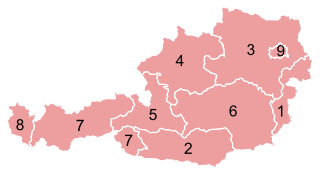
Deutsch: Karte der Bundesländer Österreichs.
English: Map of the States of Austria.
Français : Carte des Länder autrichiens.
Svenska: Karta över Österrikes förbundsländer. |
|||
| Data | ||||
| Sors |
This file was derived from: Karte A Wien.svg |
|||
| Awtur |
Original: Vector: . |
|||
| Permess (Użu mill-ġdid tal-fajl) |
|
|||
| SVG genesis | This vector image was created with unknown tool.
|


Kronoloġija tal-fajl
Agħfas fuq il-grupp data/ħin biex tara l-fajl biex tara kif jidher dak il-ħin.
| Data/Ħin | Minjatura | Qisien | Utent | Kumment | |
|---|---|---|---|---|---|
| kurrenti | 00:41, 25 Diċembru 2012 | | 512 × 280 (68 KB) | GeMet | {{Information |Description = {{de|Karte der Bundesländer Österreichs.}} {{en|Map of the States of Austria.}} {{fr|Carte des Länder autrichiens.}} {{sv|Karta öve... |
Użu tal-fajl
Il-Paġna segwenti twassal għal din l-istampa:
L-użu globali tal-fajl
Il-wikis segwenti jużaw dan il-fajl:
- Użu fuq ami.wikipedia.org
- Użu fuq an.wikipedia.org
- Użu fuq ar.wikipedia.org
- Użu fuq azb.wikipedia.org
- Użu fuq az.wikipedia.org
- Użu fuq ba.wikipedia.org
- Użu fuq be-tarask.wikipedia.org
- Użu fuq be.wikipedia.org
- Użu fuq bs.wikipedia.org
- Użu fuq ca.wikipedia.org
- Użu fuq cs.wikipedia.org
- Użu fuq de.wikipedia.org
- Użu fuq de.wikinews.org
- Użu fuq el.wikipedia.org
- Użu fuq eml.wikipedia.org
- Użu fuq en.wikipedia.org
- Użu fuq eo.wikipedia.org
- Użu fuq es.wikipedia.org
- Użu fuq et.wikipedia.org
- Użu fuq eu.wikipedia.org
- Użu fuq fa.wikipedia.org
- Użu fuq frr.wikipedia.org
- Użu fuq fr.wikipedia.org
- Użu fuq gag.wikipedia.org
- Użu fuq gd.wikipedia.org
- Użu fuq gl.wikipedia.org
- Użu fuq he.wikipedia.org
Ara l-użu globali ta' dan il-fajl.