Stampa:ROC vs PRC.svg

Size of this PNG preview of this SVG file: 800 × 548 pixels. Riżoluzzjonijiet oħra: 320 × 219 pixels | 640 × 439 pixels | 1,024 × 702 pixels | 1,280 × 878 pixels | 2,560 × 1,755 pixels | 1,339 × 918 pixels
Fajl oriġinali (Fajl fil-format SVG, dimensjoni nominali 1,339 × 918 pixel, dimensjoni tal-fajl: 1.71 MB)
| Dan huwa fajl mill-Wikimedia Commons. Il-deskrizzjoni fuq il-paġna ta' diskussjoni oriġinali tidher hawn taħt.
|
Taqsira
| Deskrizzjoni |
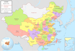
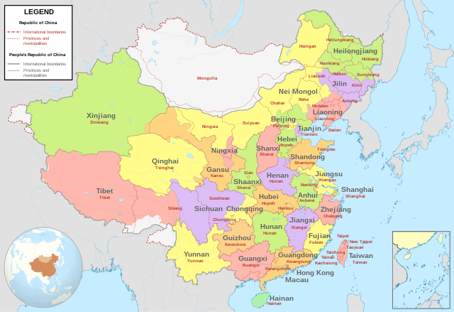
English: Comparison between Republic of China (1953-2002 in Taiwan) and People's Republic of China administrative divisions.
Adapted from File:ROC PRC comparison eng.jpg. The original ROC map included more cities, but the adaptation removed non-central municipalities to clean up the image. Therefore, this image contains: Republic of China
People's Republic of China
|
| Data | |
| Sors |
Own work based on: China (+claims, +Hainan), administrative divisions - Blank - colored.svg |
| Awtur | Milenioscuro |
,_administrative_divisions_-_Blank_-_colored.svg)
Liċenzja
Jiena, id-detentur tal-copyright ta' dan ix-xogħol, niddikjara li se nippubblikah taħt il-liċenzja segwenti:
This file is licensed under the Creative Commons Attribution-Share Alike 4.0 International license.
- Inti ħieles:
- li taqsam – li tikkopja, tiddistribwixxi u tittrażmetti din l-opra
- li timmodifika – li tadatta l-biċċa xogħol
- Taħt il-kundizzjonijiet segwenti:
- attribuzzjoni – Għandek tattribwixxi x-xogħol bil-mod speċifikat mill-awtur jew minn min ta l-l-iċenzja (imma mhux b'xi mod li jissuġġerixxi ji jappoġjaw lilek jew l-użu tax-xogħol).
- Ixxerja bl-istess mod – Jekk tbiddel, tittrasforma jew tibni fuq dan il-materjal, inti għandek bżonn taqsam il-kontribuzzjonijiet tiegħek taħt l-istess liċenzja jew waħda li taqbel ma' dik oriġinali.
- ↑ “Taiwan Veto Likely; Taipei Regime May Again Bar Outer Mongolia From U.N.”, in The New York Times[1], 22 April 1961
- ↑ 中華民國年鑑. Archived from the original on April 19, 2003. Retrieved on January 21, 2017.
Kronoloġija tal-fajl
Agħfas fuq il-grupp data/ħin biex tara l-fajl biex tara kif jidher dak il-ħin.
| Data/Ħin | Minjatura | Qisien | Utent | Kumment | |
|---|---|---|---|---|---|
| kurrenti | 05:04, 15 Lulju 2022 | | 1,339 × 918 (1.71 MB) | Tjs2012 | Adjust borders |
| 19:25, 11 April 2021 |  | 1,339 × 918 (1.71 MB) | Milenioscuro | the color reflects the political divisions of PRC, so Taiwan must be ONE color, disputed territories in white like original file | |
| 05:36, 15 Ġunju 2020 |  | 512 × 401 (1.43 MB) | Jrthsr700tmax | Add New Taipei, Taoyuan, Tainan | |
| 19:13, 15 Frar 2020 |  | 1,156 × 904 (2.18 MB) | Milenioscuro | colors of provinces | |
| 16:53, 1 Frar 2020 |  | 1,156 × 904 (2.18 MB) | Milenioscuro | User created page with UploadWizard |
Użu tal-fajl
Il-Paġna segwenti twassal għal din l-istampa:
L-użu globali tal-fajl
Il-wikis segwenti jużaw dan il-fajl:
- Użu fuq en.wikipedia.org
- Użu fuq es.wikipedia.org
- Użu fuq ja.wikipedia.org