Stampa:Dumbarton Castle - geograph.org.uk - 501609.jpg
Mhux disponibli verżjonijiet b'risoluzzjoni akbar.
Dumbarton_Castle_-_geograph.org.uk_-_501609.jpg (640 × 480 pixel, dimensjoni: 84 KB, tip ta' MIME: image/jpeg)
| Dan huwa fajl mill-Wikimedia Commons. Il-deskrizzjoni fuq il-paġna ta' diskussjoni oriġinali tidher hawn taħt.
|
Taqsira
| Deskrizzjoni |
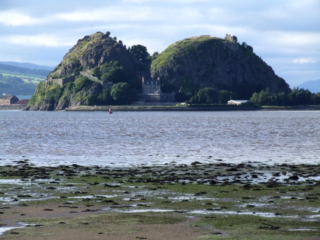
English: Dumbarton Castle A long shot from across the River Clyde,taken near the start of the M8.
South of the centre of Dumbarton rises the 240ft high twin peaked volcanic plug of Dumbarton Rock, with the River Clyde on one side and the River Leven on two more. The castle is in the care of Historic Scotland. |
| Data | |
| Sors | From geograph.org.uk |
| Awtur | Dave Hitchborne |
| Attribuzzjoni (required by the license) | Dave Hitchborne / Dumbarton Castle / |
| Camera location | | View this and other nearby images on: OpenStreetMap |
|---|
_heading:337.00&language=mt)
| Object location | | View this and other nearby images on: OpenStreetMap |
|---|
_heading:337.00&language=mt)
Liċenzja

|
This image was taken from the Geograph project collection. See this photograph's page on the Geograph website for the photographer's contact details. The copyright on this image is owned by Dave Hitchborne and is licensed for reuse under the Creative Commons Attribution-ShareAlike 2.0 license.
|
Dan il-fajl huwa liċenzjat taħt it-termini tal-liċenzja Creative Commons Attribuzzjoni-Aqsam bl-istess mod 2.0 Ġeneriku
Attribuzzjoni: Dave Hitchborne
- Inti ħieles:
- li taqsam – li tikkopja, tiddistribwixxi u tittrażmetti din l-opra
- li timmodifika – li tadatta l-biċċa xogħol
- Taħt il-kundizzjonijiet segwenti:
- attribuzzjoni – Għandek tattribwixxi x-xogħol bil-mod speċifikat mill-awtur jew minn min ta l-l-iċenzja (imma mhux b'xi mod li jissuġġerixxi ji jappoġjaw lilek jew l-użu tax-xogħol).
- Ixxerja bl-istess mod – Jekk tbiddel, tittrasforma jew tibni fuq dan il-materjal, inti għandek bżonn taqsam il-kontribuzzjonijiet tiegħek taħt l-istess liċenzja jew waħda li taqbel ma' dik oriġinali.
Kronoloġija tal-fajl
Agħfas fuq il-grupp data/ħin biex tara l-fajl biex tara kif jidher dak il-ħin.
| Data/Ħin | Minjatura | Qisien | Utent | Kumment | |
|---|---|---|---|---|---|
| kurrenti | 18:03, 19 Ottubru 2015 | | 640 × 480 (84 KB) | Rodhullandemu | Full-sized image |
| 08:18, 5 Frar 2011 |  | 60 × 60 (2 KB) | GeographBot | == {{int:filedesc}} == {{Information |description={{en|1=Dumbarton Castle A long shot from across the River Clyde,taken near the start of the M8. South of the centre of Dumbarton rises the 240ft high twin peaked volcanic plug of Dumbarton Rock, with t |
Użu tal-fajl
Il-Paġna segwenti twassal għal din l-istampa:
L-użu globali tal-fajl
Il-wikis segwenti jużaw dan il-fajl:
- Użu fuq el.wikipedia.org
- Użu fuq en.wikipedia.org
- Użu fuq es.wikipedia.org
- Użu fuq eu.wikipedia.org
- Użu fuq it.wikipedia.org
- Użu fuq kk.wikipedia.org
- Użu fuq nl.wikipedia.org
- Użu fuq ru.wikipedia.org
- Użu fuq uz.wikipedia.org
- Użu fuq vi.wikipedia.org