Stampa:Ambae island 3D pic.jpg
Fajl oriġinali (1,234 × 899 pixel, dimensjoni: 123 KB, tip ta' MIME: image/jpeg)
| Dan huwa fajl mill-Wikimedia Commons. Il-deskrizzjoni fuq il-paġna ta' diskussjoni oriġinali tidher hawn taħt.
|
Taqsira
| Deskrizzjoni |
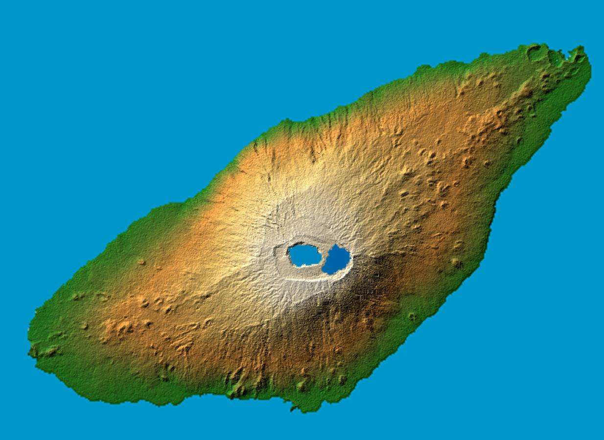
en : Ambae Island, Vanuatu. False-color, computed shadows. Colored according to elevation. Elevation data acquired by the Shuttle Radar Topography Mission on 2000-02-11 aboard Endeavour shuttle. fr: L'ile de Ambae dans l'archipel de Vanuatu. Image en relief obtenue d'apres des relevés pris par la navette Endeavour en février 2000 Location: 15.4 degree south latitude, 167.9 degrees east longitude Orientation: North toward the top, Mercator projection Size: 36.8 by 27.8 kilometers (22.9 by 17.3 miles) Image Data: shaded and colored SRTM elevation model Date Acquired: February 2000 original name : PIA06675.jpg |
| Data | |
| Sors | http://photojournal.jpl.nasa.gov/catalog/PIA06675 |
| Awtur | NASA/JPL/NGA |
This image or video was catalogued by Jet Propulsion Laboratory of the United States National Aeronautics and Space Administration (NASA) under Photo ID: PIA06675. This tag does not indicate the copyright status of the attached work. A normal copyright tag is still required. See Commons:Licensing. Other languages:
|
Liċenzja
| This file is in the public domain in the United States because it was solely created by NASA. NASA copyright policy states that "NASA material is not protected by copyright unless noted". (See Template:PD-USGov, NASA copyright policy page or JPL Image Use Policy.) | ||
 |
Warnings:
|
This image uses high-resolution digital topography data from NASA's Shuttle Radar Topography Mission (SRTM) at JPL-Caltech [4]. It is in the public domain in the United States.
|
 | |
Kronoloġija tal-fajl
Agħfas fuq il-grupp data/ħin biex tara l-fajl biex tara kif jidher dak il-ħin.
| Data/Ħin | Minjatura | Qisien | Utent | Kumment | |
|---|---|---|---|---|---|
| kurrenti | 00:28, 8 Jannar 2006 | | 1,234 × 899 (123 KB) | Oxam Hartog | en : Ambae island, Vanuatu, image acquired by the Shuttle Radar Topography Mission on 2000-02-11 aboard endeavour shuttle fr: L'ile de Ambae dans l'archipel de Vanuatu. Image en relief obtenue d'apres des relevés pris par la navette Endeavour en févrie |
Użu tal-fajl
Il-Paġna segwenti twassal għal din l-istampa:
L-użu globali tal-fajl
Il-wikis segwenti jużaw dan il-fajl:
- Użu fuq arz.wikipedia.org
- Użu fuq ast.wikipedia.org
- Użu fuq bg.wikipedia.org
- Użu fuq bi.wikipedia.org
- Użu fuq ceb.wikipedia.org
- Użu fuq cs.wikipedia.org
- Użu fuq de.wikipedia.org
- Użu fuq en.wikipedia.org
- Użu fuq en.wikiversity.org
- Użu fuq eo.wikipedia.org
- Użu fuq es.wikipedia.org
- Użu fuq et.wikipedia.org
- Użu fuq fr.wikipedia.org
- Użu fuq fr.wikivoyage.org
- Użu fuq gl.wikipedia.org
- Użu fuq he.wikipedia.org
- Użu fuq it.wikipedia.org
- Użu fuq ja.wikipedia.org
- Użu fuq ka.wikipedia.org
- Użu fuq ko.wikipedia.org
- Użu fuq lld.wikipedia.org
- Użu fuq mk.wikipedia.org
- Użu fuq mrj.wikipedia.org
- Użu fuq nl.wikipedia.org
- Użu fuq no.wikipedia.org
- Użu fuq pl.wikipedia.org
- Użu fuq pt.wikipedia.org
- Użu fuq ru.wikipedia.org
- Użu fuq uk.wikipedia.org
- Użu fuq www.wikidata.org