Stampa:Wake Island.png

Daqs tad-dehra proviżorja: 597 × 600 pixels. Riżoluzzjonijiet oħra: 239 × 240 pixels | 631 × 634 pixels
Fajl oriġinali (631 × 634 pixel, dimensjoni: 307 KB, tip ta' MIME: image/png)
| Dan huwa fajl mill-Wikimedia Commons. Il-deskrizzjoni fuq il-paġna ta' diskussjoni oriġinali tidher hawn taħt.
|
|
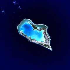
This is an image of a place or building that is listed on the National Register of Historic Places in the United States of America. Its reference number is 85002726. |
Wake Island - NASA NLT Landsat 7 (Visible Color) Satellite Image
| This file is in the public domain in the United States because it was solely created by NASA. NASA copyright policy states that "NASA material is not protected by copyright unless noted". (See Template:PD-USGov, NASA copyright policy page or JPL Image Use Policy.) | ||
 |
Warnings:
|
| Object location | | View this and other nearby images on: OpenStreetMap |
|---|
Kronoloġija tal-fajl
Agħfas fuq il-grupp data/ħin biex tara l-fajl biex tara kif jidher dak il-ħin.
| Data/Ħin | Minjatura | Qisien | Utent | Kumment | |
|---|---|---|---|---|---|
| kurrenti | 15:05, 10 April 2005 | | 631 × 634 (307 KB) | Bollar | Wake Island - NASA NLT Landsat 7 (Visible Color) Satellite Image {{PD-USGov-NASA}} |
Użu tal-fajl
Il-Paġna segwenti twassal għal din l-istampa:
L-użu globali tal-fajl
Il-wikis segwenti jużaw dan il-fajl:
- Użu fuq af.wikipedia.org
- Użu fuq als.wikipedia.org
- Użu fuq ast.wikipedia.org
- Użu fuq cr.wikipedia.org
- Użu fuq da.wikipedia.org
- Użu fuq de.wikipedia.org
- Użu fuq en.wikipedia.org
- Użu fuq es.wikipedia.org
- Użu fuq et.wikipedia.org
- Użu fuq eu.wikipedia.org
- Użu fuq fi.wikipedia.org
- Użu fuq frp.wikipedia.org
- Użu fuq frr.wikipedia.org
- Użu fuq fr.wikipedia.org
- Użu fuq gl.wikipedia.org
- Użu fuq hi.wikipedia.org
- Użu fuq id.wikipedia.org
- Użu fuq is.wikipedia.org
- Użu fuq it.wikipedia.org
- Użu fuq ja.wikinews.org
- Użu fuq jv.wikipedia.org
- Użu fuq ko.wikipedia.org
- Użu fuq la.wikipedia.org
- Użu fuq lv.wikipedia.org
- Użu fuq ms.wikipedia.org
- Użu fuq no.wikipedia.org
- Użu fuq pap.wikipedia.org
- Użu fuq pl.wiktionary.org
- Użu fuq pt.wikipedia.org
- Użu fuq ro.wikipedia.org
Ara l-użu globali ta' dan il-fajl.