Stampa:Tahaa and Raiatea topographic map - with communes et communes associées.svg

Size of this PNG preview of this SVG file: 374 × 599 pixels. Riżoluzzjonijiet oħra: 150 × 240 pixels | 300 × 480 pixels | 480 × 768 pixels | 639 × 1,024 pixels | 1,279 × 2,048 pixels | 714 × 1,143 pixels
Fajl oriġinali (Fajl fil-format SVG, dimensjoni nominali 714 × 1,143 pixel, dimensjoni tal-fajl: 333 KB)
| Dan huwa fajl mill-Wikimedia Commons. Il-deskrizzjoni fuq il-paġna ta' diskussjoni oriġinali tidher hawn taħt.
|
Taqsira
| Deskrizzjoni | |
| Data | |
| Sors |
Œuvre personnelle.
Données :
Logiciels utilisés :
Autres informations :
|
| Awtur | Sardon, derivative work of the original work by Maximilian Dörrbecker (Chumwa) |
| Verżjonijiet oħra | Macedonian |
Liċenzja
| I, the copyright holder of this work, release this work into the public domain. This applies worldwide. In some countries this may not be legally possible; if so: I grant anyone the right to use this work for any purpose, without any conditions, unless such conditions are required by law. |
Kronoloġija tal-fajl
Agħfas fuq il-grupp data/ħin biex tara l-fajl biex tara kif jidher dak il-ħin.
| Data/Ħin | Minjatura | Qisien | Utent | Kumment | |
|---|---|---|---|---|---|
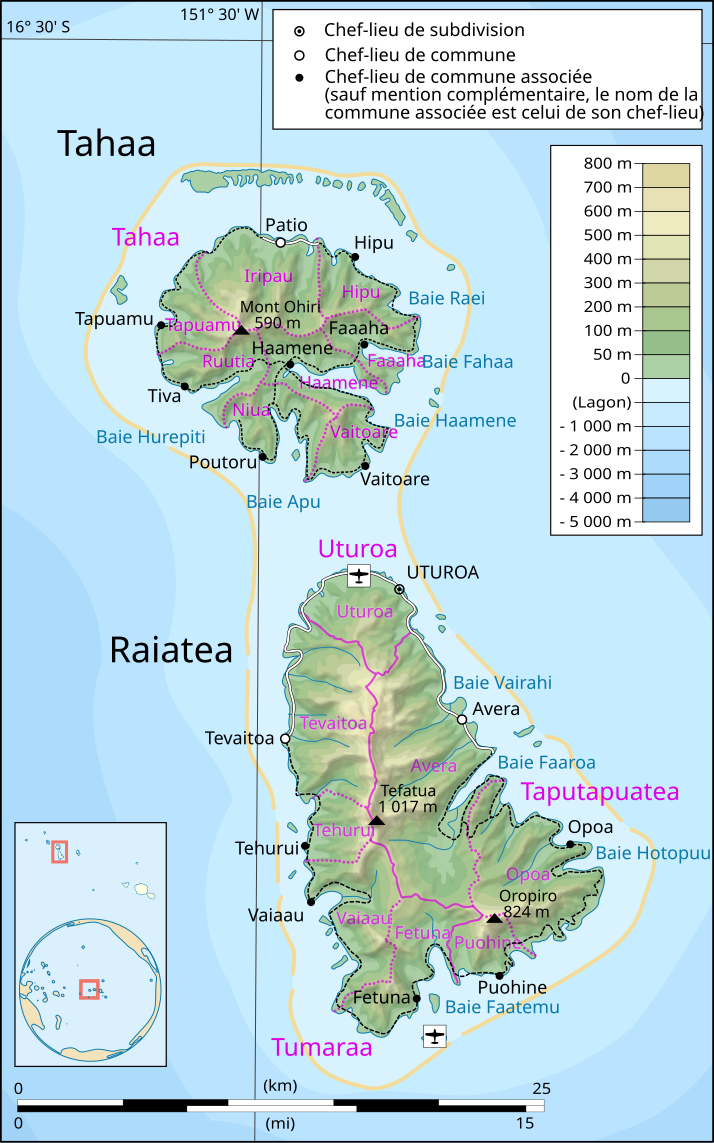
| kurrenti | 06:20, 12 Mejju 2015 | | 714 × 1,143 (333 KB) | Chumwa | == {{int:filedesc}} == {{Information |Description={{en|1=Topographic map in French of the islands of Tahaa and Raiatea, Society Islands, French Polynesia.}} {{fr|1=Carte topographique en français des îles de [[:fr:Tahaa|... |
Użu tal-fajl
Il-Paġna segwenti twassal għal din l-istampa:
L-użu globali tal-fajl
Il-wikis segwenti jużaw dan il-fajl:
- Użu fuq de.wikipedia.org
- Użu fuq eo.wikipedia.org
- Użu fuq es.wikipedia.org
- Użu fuq fr.wikipedia.org
- Użu fuq it.wikipedia.org
- Użu fuq ja.wikipedia.org
- Użu fuq lt.wikipedia.org
- Użu fuq nl.wikipedia.org
- Użu fuq no.wikipedia.org
- Użu fuq oc.wikipedia.org
- Użu fuq pl.wikipedia.org
- Użu fuq pt.wikipedia.org
- Użu fuq ru.wikipedia.org
- Użu fuq zh.wikipedia.org