Stampa:Tabula hungariae.jpg

Daqs tad-dehra proviżorja: 421 × 600 pixels. Riżoluzzjonijiet oħra: 168 × 240 pixels | 337 × 480 pixels | 539 × 768 pixels | 719 × 1,024 pixels | 1,438 × 2,048 pixels | 3,236 × 4,609 pixels
Fajl oriġinali (3,236 × 4,609 pixel, dimensjoni: 3.27 MB, tip ta' MIME: image/jpeg)
| Dan huwa fajl mill-Wikimedia Commons. Il-deskrizzjoni fuq il-paġna ta' diskussjoni oriġinali tidher hawn taħt.
|
Taqsira
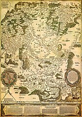
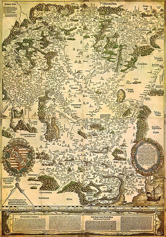
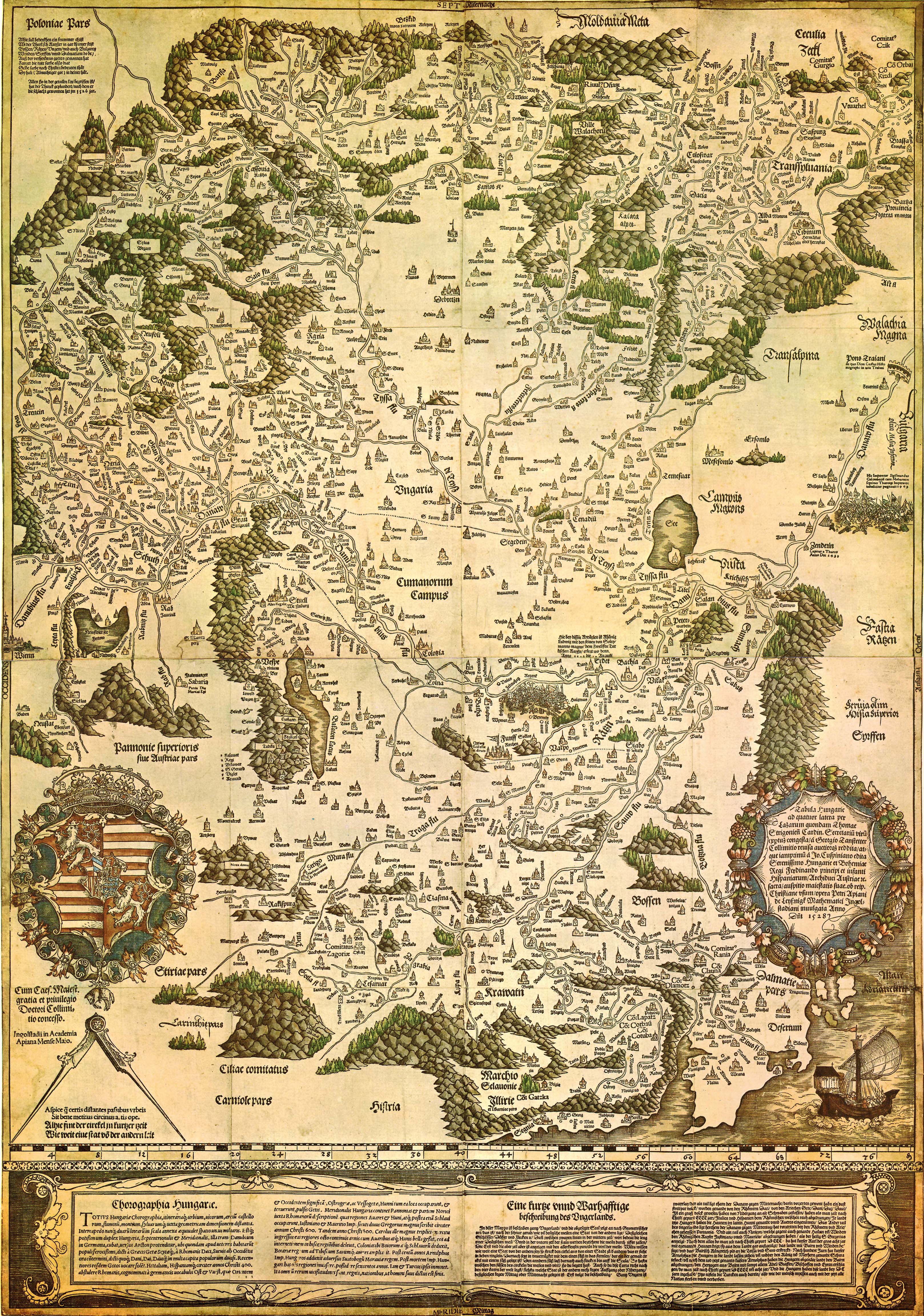
| Tabula Hungariae
|
||
|---|---|---|
| Awtur |
Lázár deák (Lazarus secretarius) |
 |
| Titlu |
Latin: Tabula Hungarie ad quatuor latera Tabula Hungariae |
|
| Stampatur | ||
| Object type |
antique map |
|
| Deskrizzjoni |
Magyar: A Tabula Hungariae vagy Lázár térképe Magyarország első nyomtatott térképe, amelyet a feltehetően a magyar Lázár deák készített Српски / srpski: Lazarusova karta Ugarske iz 1528. godine na kojoj je na mestu današnjeg Novog Sada ubeleženo naselje Bistritz (Bistrica) |
|
| Data | 1526 - 1528 | |
| Data tal-pubblikazzjoni |
1528 |
|
| Collection | ||
| Referenzi | ||
| Authority file | ||
| Sors/Fotografu | http://lazarus.elte.hu/hun/maps/lazar150.jpg | |
| Verżjonijiet oħra |
|
|


Liċenzja
|
This work is in the public domain in its country of origin and other countries and areas where the copyright term is the author's life plus 100 years or fewer. This work is in the public domain in the United States because it was published (or registered with the U.S. Copyright Office) before January 1, 1929. | |
| This file has been identified as being free of known restrictions under copyright law, including all related and neighboring rights. | |
Kronoloġija tal-fajl
Agħfas fuq il-grupp data/ħin biex tara l-fajl biex tara kif jidher dak il-ħin.
| Data/Ħin | Minjatura | Qisien | Utent | Kumment | |
|---|---|---|---|---|---|
| kurrenti | 23:02, 29 Awwissu 2009 | | 3,236 × 4,609 (3.27 MB) | Qorilla | {{Information |Description={{en|1=Tabula Hungariae, first printed map of Hungary}} |Source=Hungarian Wikipedia |Author=Lázár deák (Lazarus secretarius) |Date=somewhere between 1526-1528 |Permission= |other_versions= }} Category:Old maps of Hungary |
Użu tal-fajl
Il-Paġna segwenti twassal għal din l-istampa:
L-użu globali tal-fajl
Il-wikis segwenti jużaw dan il-fajl:
- Użu fuq ar.wikipedia.org
- Użu fuq bn.wikipedia.org
- Użu fuq bs.wikipedia.org
- Użu fuq ca.wikipedia.org
- Użu fuq de.wikipedia.org
- Użu fuq el.wikipedia.org
- Użu fuq en.wikipedia.org
- Pannonia
- Treaty of Trianon
- Hungarian Revolution of 1956
- Austro-Hungarian Compromise of 1867
- Military Frontier
- Hungarian nobility
- History of Hungary before the Hungarian conquest
- Hungarian prehistory
- Kingdom of Hungary (1526–1867)
- History of geography
- Georg Tannstetter
- Upper Hungary
- History of the Jews in Hungary
- Music history of Hungary
- Bistrica, Novi Sad
- Lands of the Crown of Saint Stephen
- History of Transylvania
- Template:History of Hungary
- Hungarian People's Republic
- Principality of Transylvania (1570–1711)
- Military history of Hungary
- First Hungarian Republic
- Ottoman Hungary
- Hungary between the World Wars
- Principality of Hungary
- Hungarian Revolution of 1848
- Rákóczi's War of Independence
- Eastern Hungarian Kingdom
- Kingdom of Hungary (1920–1946)
- Hungary in World War I
- Second Hungarian Republic
Ara l-użu globali ta' dan il-fajl.