Stampa:Partitions of Moldavia.jpg

Daqs tad-dehra proviżorja: 215 × 597 pixels. Riżoluzzjonijiet oħra: 86 × 240 pixels | 172 × 480 pixels | 665 × 1,848 pixels
Fajl oriġinali (665 × 1,848 pixel, dimensjoni: 635 KB, tip ta' MIME: image/jpeg)
| Dan huwa fajl mill-Wikimedia Commons. Il-deskrizzjoni fuq il-paġna ta' diskussjoni oriġinali tidher hawn taħt.
|

|
This historical map image could be re-created using vector graphics as an SVG file. This has several advantages; see Commons:Media for cleanup for more information. If an SVG form of this image is available, please upload it and afterwards replace this template with
{{vector version available|new image name}}.
It is recommended to name the SVG file “Partitions of Moldavia.svg”—then the template Vector version available (or Vva) does not need the new image name parameter. |


Taqsira
| Deskrizzjoni |
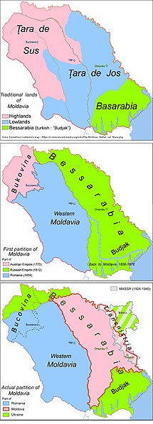
English: Historic map: partitions of Moldavia |
| Data | |
| Sors | Opra proprja |
| Awtur | Aoleuvaidenoi |
Liċenzja
| I, the copyright holder of this work, release this work into the public domain. This applies worldwide. In some countries this may not be legally possible; if so: I grant anyone the right to use this work for any purpose, without any conditions, unless such conditions are required by law. |
Kronoloġija tal-fajl
Agħfas fuq il-grupp data/ħin biex tara l-fajl biex tara kif jidher dak il-ħin.
| Data/Ħin | Minjatura | Qisien | Utent | Kumment | |
|---|---|---|---|---|---|
| kurrenti | 09:53, 9 April 2019 | 665 × 1,848 (635 KB) | Julieta39 | Correct Iași (Яссы) County since the same map. | |
| 11:06, 5 Ottubru 2018 | 665 × 1,848 (634 KB) | Julieta39 | Correct Highlands & Lowlands since Demetrius Cantemir's map restituted by Vladimir Mironescu: see [https://commons.wikimedia.org/wiki/File:Moldova_Stefan_cel_Mare.png] | ||
| 18:35, 8 Mejju 2015 | 665 × 1,848 (605 KB) | Spiridon Ion Cepleanu | Colours | ||
| 17:40, 30 Diċembru 2010 | 665 × 1,848 (582 KB) | Aoleuvaidenoi | {{Information |Description={{en|1=Historic map: partitions of Moldavia}} |Source={{own}} |Author=Aoleuvaidenoi |Date=December 30, 2010 |Permission= |other_versions= }} Category:Maps of Moldova |
Użu tal-fajl
L-użu globali tal-fajl
Il-wikis segwenti jużaw dan il-fajl:
- Użu fuq ar.wikipedia.org
- Użu fuq azb.wikipedia.org
- Użu fuq ba.wikipedia.org
- Użu fuq br.wikipedia.org
- Użu fuq bs.wikipedia.org
- Użu fuq de.wikipedia.org
- Użu fuq el.wikipedia.org
- Użu fuq en.wikipedia.org
- Użu fuq es.wikipedia.org
- Użu fuq et.wikipedia.org
- Użu fuq fr.wikipedia.org
- Użu fuq hu.wikipedia.org
- Użu fuq io.wikipedia.org
- Użu fuq it.wikipedia.org
- Użu fuq lt.wikipedia.org
- Użu fuq lv.wikipedia.org
- Użu fuq mk.wikipedia.org
- Użu fuq ms.wikipedia.org
- Użu fuq pl.wikipedia.org
- Użu fuq pnb.wikipedia.org
- Użu fuq pt.wikipedia.org
- Użu fuq rm.wikipedia.org
- Użu fuq ro.wikipedia.org
Ara l-użu globali ta' dan il-fajl.