Stampa:Mtcook.nz.750pix.jpg
Daqs tad-dehra proviżorja: 650 × 600 pixels. Riżoluzzjonijiet oħra: 260 × 240 pixels | 520 × 480 pixels | 832 × 768 pixels | 1,110 × 1,024 pixels | 2,219 × 2,048 pixels | 6,108 × 5,637 pixels
Fajl oriġinali (6,108 × 5,637 pixel, dimensjoni: 4.66 MB, tip ta' MIME: image/jpeg)
| Dan huwa fajl mill-Wikimedia Commons. Il-deskrizzjoni fuq il-paġna ta' diskussjoni oriġinali tidher hawn taħt.
|
Taqsira
| Deskrizzjoni |
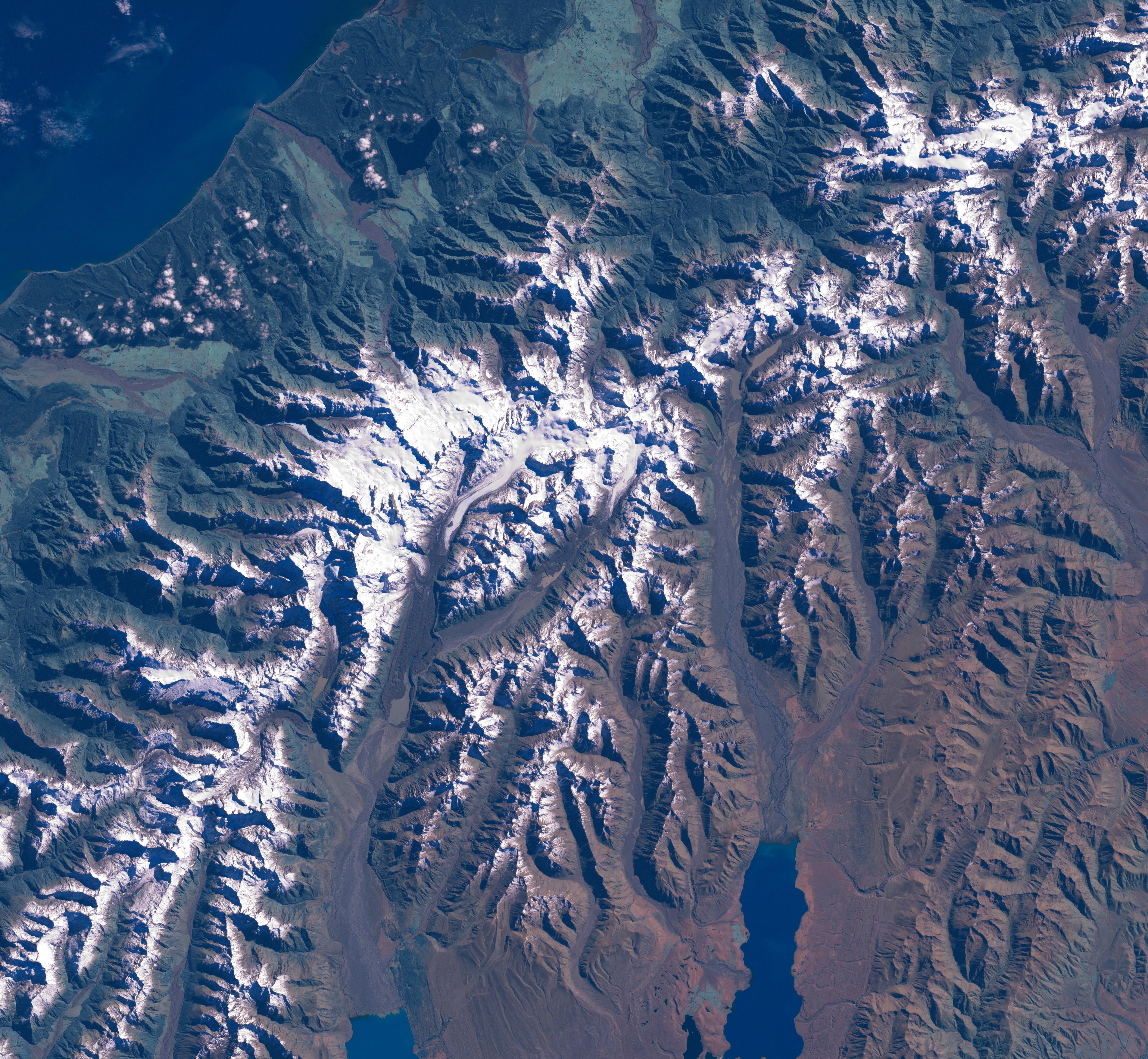
The Aoraki/Mount Cook area from LandSat. This image was acquired by Landsat 7's Enhanced Thematic Mapper plus (ETM ) sensor on March 31, 2001. This is a true-color image made using red, green, and blue wavelengths (ETM bands 3, 2, and 1). The image has also been pan-sharpened to heighten the details and resolution. |
| Sors |
SOURCE:
http://earthobservatory.nasa.gov/Newsroom/NewImages/images.php3?img_id=15331
This image was acquired by Landsat 7's Enhanced Thematic Mapper plus (ETM ) sensor on March 31, 2001. This is a true-color image made using red, green, and blue wavelengths (ETM bands 3, 2, and 1). The image has also been pan-sharpened to heighten the details and resolution. ”The purpose of NASA's Earth Observatory is to provide a freely-accessible publication on the Internet where the public can obtain new satellite imagery and scientific information about our home planet. The focus is on Earth's climate and environmental change. In particular, we hope our site is useful to public media and educators. Any and all materials published on the Earth Observatory are freely available for re-publication or re-use, except where copyright is indicated. We ask that NASA's Earth Observatory be given credit for its original materials.” |
| Awtur | Picture prepared for Wikipedia by Adrian Pingstone in November 2003. |
| Permess (Użu mill-ġdid tal-fajl) |
PD |
Original authors
- Source: en.wikipedia.org
- Upload Tool Operator: Flominator (Flominator)
- Image contributor(s): Arpingstone
- 17:49, 7 November 2003 Arpingstone 750×750 (116,804 bytes) (Mount Cook from LandSat)
Liċenzja
| This file is in the public domain in the United States because it was solely created by NASA. NASA copyright policy states that "NASA material is not protected by copyright unless noted". (See Template:PD-USGov, NASA copyright policy page or JPL Image Use Policy.) | ||
 |
Warnings:
|
Kronoloġija tal-fajl
Agħfas fuq il-grupp data/ħin biex tara l-fajl biex tara kif jidher dak il-ħin.
| Data/Ħin | Minjatura | Qisien | Utent | Kumment | |
|---|---|---|---|---|---|
| kurrenti | 16:20, 24 Frar 2007 | | 6,108 × 5,637 (4.66 MB) | Tom | higher res and w/o english words |
| 08:32, 29 Awwissu 2006 |  | 750 × 750 (114 KB) | CommonismNow | {{Information| |Description=This image was acquired by Landsat 7's Enhanced Thematic Mapper plus (ETM ) sensor on March 31, 2001. This is a true-color image made using red, green, and blue wavelengths (ETM bands 3, 2, and 1). The image has also been pan- |
Użu tal-fajl
Il-Paġna segwenti twassal għal din l-istampa:
L-użu globali tal-fajl
Il-wikis segwenti jużaw dan il-fajl:
- Użu fuq ar.wikipedia.org
- Użu fuq bg.wikipedia.org
- Użu fuq bn.wikipedia.org
- Użu fuq ca.wikipedia.org
- Użu fuq cy.wikipedia.org
- Użu fuq da.wikipedia.org
- Użu fuq de.wikipedia.org
- Użu fuq en.wikipedia.org
- Użu fuq es.wikipedia.org
- Użu fuq eu.wikipedia.org
- Użu fuq hr.wikipedia.org
- Użu fuq ja.wikipedia.org
- Użu fuq nn.wikipedia.org
- Użu fuq pt.wikipedia.org
- Użu fuq sh.wikipedia.org
- Użu fuq sl.wikipedia.org